|
|
Title | Date | Type | Setname |
| 951 |
 |
Aerial view of Salt Lake City [4] | 1930; 1931; 1932; 1933; 1934; 1935; 1936; 1937; 1938; 1939; 1940; 1941; 1942; 1943; 1944; 1945; 1946; 1947; 1948; 1949; 1950; 1951; 1952; 1953; 1954; 1955; 1956; 1957; 1958; 1959; 1960; 1961; 1962; 1963; 1964; 1965; 1966; 1967; 1968; 1969; 1970; 1971; 1972; 1973; 1974; 1975; 1976; 1977; 1978; 1979 | Image | uum_map |
| 952 |
 |
Aerial view of Salt Lake City [4] | 1930; 1931; 1932; 1933; 1934; 1935; 1936; 1937; 1938; 1939; 1940; 1941; 1942; 1943; 1944; 1945; 1946; 1947; 1948; 1949; 1950; 1951; 1952; 1953; 1954; 1955; 1956; 1957; 1958; 1959; 1960; 1961; 1962; 1963; 1964; 1965; 1966; 1967; 1968; 1969; 1970; 1971; 1972; 1973; 1974; 1975; 1976; 1977; 1978; 1979 | Image | uum_map |
| 953 |
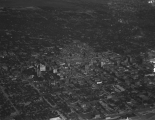 |
Aerial view of Salt Lake City [5] | 1930; 1931; 1932; 1933; 1934; 1935; 1936; 1937; 1938; 1939; 1940; 1941; 1942; 1943; 1944; 1945; 1946; 1947; 1948; 1949; 1950; 1951; 1952; 1953; 1954; 1955; 1956; 1957; 1958; 1959; 1960; 1961; 1962; 1963; 1964; 1965; 1966; 1967; 1968; 1969; 1970; 1971; 1972; 1973; 1974; 1975; 1976; 1977; 1978; 1979 | Image | uum_map |
| 954 |
 |
Aerial view of Salt Lake City [6] | 1930; 1931; 1932; 1933; 1934; 1935; 1936; 1937; 1938; 1939; 1940; 1941; 1942; 1943; 1944; 1945; 1946; 1947; 1948; 1949; 1950; 1951; 1952; 1953; 1954; 1955; 1956; 1957; 1958; 1959; 1960; 1961; 1962; 1963; 1964; 1965; 1966; 1967; 1968; 1969; 1970; 1971; 1972; 1973; 1974; 1975; 1976; 1977; 1978; 1979 | Image | uum_map |
| 955 |
 |
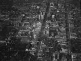
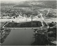
Aerial view of Salt Lake City [8] | 1930; 1931; 1932; 1933; 1934; 1935; 1936; 1937; 1938; 1939; 1940; 1941; 1942; 1943; 1944; 1945; 1946; 1947; 1948; 1949; 1950; 1951; 1952; 1953; 1954; 1955; 1956; 1957; 1958; 1959; 1960; 1961; 1962; 1963; 1964; 1965; 1966; 1967; 1968; 1969; 1970; 1971; 1972; 1973; 1974; 1975; 1976; 1977; 1978; 1979 | Image | uum_map |
| 956 |
 |
Aerial view of Temple Square in Salt Lake City. | 1960; 1961; 1962; 1963; 1964; 1965; 1966; 1967; 1968; 1969; 1970; 1971; 1972; 1973; 1974; 1975; 1976; 1977; 1978; 1979 | | uum_map |
| 957 |
 |
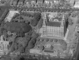
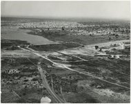
Aerial view of Temple Square, Salt Lake City [1] | 1930; 1931; 1932; 1933; 1934; 1935; 1936; 1937; 1938; 1939; 1940; 1941; 1942; 1943; 1944; 1945; 1946; 1947; 1948; 1949; 1950; 1951; 1952; 1953; 1954; 1955; 1956; 1957; 1958; 1959; 1960; 1961; 1962; 1963; 1964; 1965; 1966; 1967; 1968; 1969; 1970; 1971; 1972; 1973; 1974; 1975; 1976; 1977; 1978; 1979 | Image | uum_map |
| 958 |
 |
Aerial view of Temple Square, Salt Lake City [2] | 1930; 1931; 1932; 1933; 1934; 1935; 1936; 1937; 1938; 1939; 1940; 1941; 1942; 1943; 1944; 1945; 1946; 1947; 1948; 1949; 1950; 1951; 1952; 1953; 1954; 1955; 1956; 1957; 1958; 1959; 1960; 1961; 1962; 1963; 1964; 1965; 1966; 1967; 1968; 1969; 1970; 1971; 1972; 1973; 1974; 1975; 1976; 1977; 1978; 1979 | Image | uum_map |
| 959 |
 |
Aerial view of the Nchanga copper mine, central Africa [01] | 1964; 1965; 1966; 1967; 1968; 1969 | Image | uum_map |
| 960 |
 |
Aerial view of the Nchanga copper mine, central Africa [02] | 1964; 1965; 1966; 1967; 1968; 1969 | Image | uum_map |
| 961 |
 |
Aerial view of the Nchanga copper mine, central Africa [03] | 1964; 1965; 1966; 1967; 1968; 1969 | Image | uum_map |
| 962 |
 |
Aerial view of the Nchanga copper mine, central Africa [04] | 1964; 1965; 1966; 1967; 1968; 1969 | Image | uum_map |
| 963 |
 |
Aerial view of the Nchanga copper mine, central Africa [05] | 1964; 1965; 1966; 1967; 1968; 1969 | Image | uum_map |
| 964 |
 |
Aerial view of the newly completed Washington D.C. Temple. | 1960; 1961; 1962; 1963; 1964; 1965; 1966; 1967; 1968; 1969 | | uum_map |
| 965 |
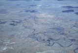 |
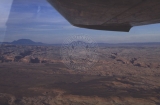
aerial view of unidentified river | 1950; 1951; 1952; 1953; 1954; 1955; 1956; 1957; 1958; 1959; 1960; 1961; 1962; 1963; 1964; 1965; 1966; 1967; 1968; 1969; 1970; 1971; 1972; 1973; 1974; 1975; 1976; 1977; 1978; 1979; 1980 | Image | uum_map_rr |
| 966 |
 |
Aerial view of University of Utah Medical Center, 1964 | 1964 | Image/StillImage | uum_map |
| 967 |
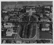 |
Aerial view of University of Utah Presidents Circle | 1950; 1951; 1952; 1953; 1954; 1955; 1956; 1957; 1958; 1959; 1960; 1961; 1962; 1963; 1964; 1965; 1966; 1967; 1968; 1969; 1970; 1971; 1972; 1973 | Image/StillImage | uum_map |
| 968 |
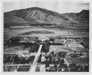 |
Aerial view of University of Utah Presidents Circle and mountains | 1950; 1951; 1952; 1953; 1954; 1955; 1956; 1957; 1958; 1959; 1960; 1961; 1962; 1963; 1964; 1965; 1966; 1967; 1968; 1969; 1970; 1971; 1972; 1973 | Image/StillImage | uum_map |
| 969 |
 |
Aerial view of University of Utah Special Events Center and Health, Physical Education, and Recreation buildings | 1950; 1951; 1952; 1953; 1954; 1955; 1956; 1957; 1958; 1959; 1960; 1961; 1962; 1963; 1964; 1965; 1966; 1967; 1968; 1969; 1970; 1971; 1972; 1973 | Image/StillImage | uum_map |
| 970 |
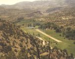 |
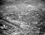
AERIAL VIEW OF WILCOX RANCH WITH AIRSTRIP | 1950; 1951; 1952; 1953; 1954; 1955; 1956; 1957; 1958; 1959; 1960; 1961; 1962; 1963; 1964; 1965; 1966; 1967; 1968; 1969; 1970; 1971; 1972; 1973; 1974; 1975; 1976; 1977; 1978; 1979 | Image | uum_map |
| 971 |
 |
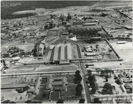
Aerial views of factories | 1940; 1941; 1942; 1943; 1944; 1945; 1946; 1947; 1948; 1949; 1950; 1951; 1952; 1953; 1954; 1955; 1956; 1957; 1958; 1959; 1960; 1961; 1962; 1963; 1964; 1965; 1966; 1967; 1968; 1969; 1970 | Image | uum_map |
| 972 |
 |
Aerial views of the Escalante River canyons, post-Lake Powell | 1963; 1964; 1965; 1966; 1967; 1968 | Image | uum_map_rr |
| 973 |
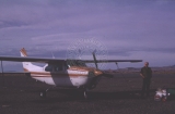 |
Aerial views of the Escalante River canyons, post-Lake Powell - Cessna 210, David Thompson. | 1963; 1964; 1965; 1966; 1967; 1968 | Image | uum_map_rr |
| 974 |
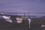 |
Aerial views of the Escalante River canyons, post-Lake Powell - Cessna 210, Gregg Dimmitt | 1963; 1964; 1965; 1966; 1967; 1968 | Image | uum_map_rr |
| 975 |
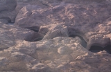 |
Aerial views of the Escalante River canyons, post-Lake Powell - Lagorce Arch. | 1963; 1964; 1965; 1966; 1967; 1968 | Image | uum_map_rr |