Home
Browse
Ask Us
Chat
Harmful Language Statement
Log in
Advanced Search
Year
1849
1850
1851
1852
1853
1854
1855
1856
1857
1858
1859
1860
1861
1862
1863
1864
1865
1866
1867
1868
1869
1870
1871
1872
1873
1874
1875
1876
1877
1878
1879
1880
1881
1882
1883
1884
1885
1886
1887
1888
1889
1890
1891
1892
1893
1894
1895
1896
1897
1898
1899
1900
1901
1902
1903
1904
1905
1906
1907
1908
1909
1910
1911
1912
1913
1914
1915
1916
1917
1918
1919
1920
1921
1922
1923
1924
1925
1926
1927
1928
1929
1930
1931
1932
1933
1934
1935
1936
1937
1938
1939
1940
1941
1942
1943
1944
1945
1946
1947
1948
1949
1950
1951
1952
1953
1954
1955
1956
1957
1958
1959
1960
1961
1962
1963
1964
1965
1966
1967
1968
1969
1970
1971
1972
1973
1974
1975
1976
1977
1978
1979
1980
1981
1982
1983
1984
1985
1986
1987
1988
1989
1990
1991
1992
1993
1994
1995
1996
1997
1998
1999
2000
2001
2002
2003
2004
2005
2006
2007
2008
2009
2010
2011
2012
2013
2014
2015
2016
2017
2018
2019
2020
2021
2022
2023
TO
1849
1850
1851
1852
1853
1854
1855
1856
1857
1858
1859
1860
1861
1862
1863
1864
1865
1866
1867
1868
1869
1870
1871
1872
1873
1874
1875
1876
1877
1878
1879
1880
1881
1882
1883
1884
1885
1886
1887
1888
1889
1890
1891
1892
1893
1894
1895
1896
1897
1898
1899
1900
1901
1902
1903
1904
1905
1906
1907
1908
1909
1910
1911
1912
1913
1914
1915
1916
1917
1918
1919
1920
1921
1922
1923
1924
1925
1926
1927
1928
1929
1930
1931
1932
1933
1934
1935
1936
1937
1938
1939
1940
1941
1942
1943
1944
1945
1946
1947
1948
1949
1950
1951
1952
1953
1954
1955
1956
1957
1958
1959
1960
1961
1962
1963
1964
1965
1966
1967
1968
1969
1970
1971
1972
1973
1974
1975
1976
1977
1978
1979
1980
1981
1982
1983
1984
1985
1986
1987
1988
1989
1990
1991
1992
1993
1994
1995
1996
1997
1998
1999
2000
2001
2002
2003
2004
2005
2006
2007
2008
2009
2010
2011
2012
2013
2014
2015
2016
2017
2018
2019
2020
2021
2022
2023
Type
Image
501
Image/StillImage
202
Text
112
Sound
16
Image/MovingImage
3
Format
image/jpeg
1,775
application/pdf
208
video/mp4
18
audio/mpeg
1
Collection
Al W. Morton Collection, 1930s-1950s
1
American Westward Migration
6
Audio-Visual Archives Collections - R...
1
Beckwith Photograph Collection
2
Classified Photographs
151
College of Law Publications
1
Downwinders of Utah Archive
1
Home Movie Collection - Reading Room ...
1
Humanities In Focus
1
Multimedia Archives Photographs - Rea...
1
Peoples of Utah
1
Philip T. Blair Family Papers
1
Photo Archives
240
Shipler Commercial Photographers
112
Ski and Snow Sports Photo Archives
11
UAIDA Main Collection
136
Uintah County Regional History Center...
3
Utah Humanities Research Foundation
4
Utah Quilt Heritage Records
1
Utah River Running Photo Archives
137
Vertebrate Zoology Voucher Images
1,164
Western Soundscape
4
Western Waters Audio-Video
12
Western Waters Documents
3
Western Waters Electronic Resources
18
More
Filters:
Spatial Coverage:
"Nevada"
451
-
475
of
2,013
<
14
15
16
17
18
19
20
21
22
23
>
Gallery view
Number of results to display per page
10
25
50
100
200
Sort by Relevance
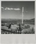
Sort by Title A-Z
Sort by Title Z-A
Sort by Date Ascending
Sort by Date Descending
Sort by Last Modified Ascending
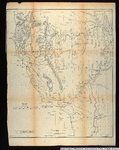
Sort by Last Modified Descending
Title
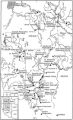
Date
Type
Setname
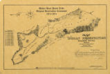
451
Longwell 2, Charleston Peak viewed from the south
1924
Image
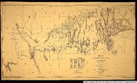
uum_map
452
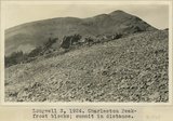
Longwell 3, 1924. Charleston Peak Frost blocks, summit peak in distance
1924
Image
uum_map
453
Longwell 4, Charleston Peak, frost blocks and vegetation. Dr. L.F. Noble standing
1924
Image
uum_map
454
Longwell 5, Charleston Peak looking south from summit
1924
Image
uum_map
455
Longwell 6, 1924. Charleston Peak. Summit. Dr. Noble and Professor Gregory
1924
Image
uum_map
456
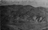
Looking Northeast -- Joe Dandy, Scotchman
1908; 1909; 1910; 1911; 1912
Image
uum_map
457
Lower Colorado Region comprehensive framework study of water and land resources : summary report, June 1971
1971-06
Text
wwdl_documents
458
Lower Colorado Region Comprehensive Framework Study: Main Report 1971
1971
Text
wwdl_documents
459
Lucinda Duncan grave marker, Nevada
1945; 1946; 1947; 1948; 1949; 1950; 1951; 1952; 1953; 1954; 1955; 1956; 1957; 1958; 1959; 1960; 1961; 1962; 1963; 1964; 1965
Image
uum_map
460
Machinery
1908; 1909; 1910; 1911; 1912
Image
uum_map
461
Machinery
1908; 1909; 1910; 1911; 1912
Image
uum_map
462
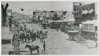
Main Street, Goldfield, Nevada
1903; 1904; 1905; 1906
Image
uum_map
463
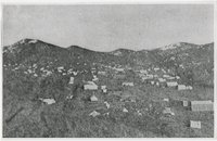
Manhattan, 1905, Nevada
1905
Image
uum_map
464
Map no. 2, from the Great Salt Lake to the Humboldt Mountains.
1855
Image/StillImage
uu_awm
465
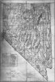
Map of Nevada 1908; Photographic copy of General Land Office Mape of the State of Nevada, with location of Ophir Mines drawn in
1908; 1909; 1910; 1911; 1912
Image
uum_map
466
Map of Shoshone Indian Territory, and the Division of Shoshone Boundaries in Nevada
Image/StillImage
uaida_main
467
Map of Shoshone, Goshute, Bannock, Wind River and Panamint Indian Tribal Groups
1957
Image/StillImage
uaida_main
468
Map of wagon routes in Utah Territory explored and opened by Capt. J. H. Simpson...in 1858-59.
1859
Image/StillImage
uu_awm
469
Map of Walker River Paiute Tribe Original Reservation Centennial 1874-1974
1874
Image/StillImage
uaida_main
470
Map of Western Indian Territory Before 1850
Image/StillImage
uaida_main
471
Map of Western Shoshone and Northern Paiute Territory
Image/StillImage
uaida_main
472
Map showing the boundary of the Shoshone Indian territory
1941
Image/StillImage
uaida_main
473
Map showing the different routes travelled over by the detachments of the Overland Command in the spring of 1855 from Salt Lake City, Utah, to the Bay of San Francisco.
1855
Image/StillImage
uu_awm
474
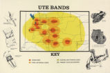
Map titled "Ute Bands Map"
Image/StillImage
uaida_main
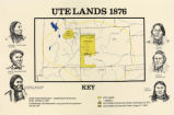
475
Map titled "Ute Lands, 1876"
Image/StillImage
uaida_main
451
-
475
of
2,013
<
14
15
16
17
18
19
20
21
22
23
>