Home
Browse
Ask Us
Chat
Harmful Language Statement
Log in
Advanced Search
Year
1847
1848
1849
1850
1851
1852
1853
1854
1855
1856
1857
1858
1859
1860
1861
1862
1863
1864
1865
1866
1867
1868
1869
1870
1871
1872
1873
1874
1875
1876
1877
1878
1879
1880
1881
1882
1883
1884
1885
1886
1887
1888
1889
1890
1891
1892
1893
1894
1895
1896
1897
1898
1899
1900
1901
1902
1903
1904
1905
1906
1907
1908
1909
1910
1911
1912
1913
1914
1915
1916
1917
1918
1919
1920
1921
1922
1923
1924
1925
1926
1927
1928
1929
1930
1931
1932
1933
1934
1935
1936
1937
1938
1939
1940
1941
1942
1943
1944
1945
1946
1947
1948
1949
1950
1951
1952
1953
1954
1955
1956
1957
1958
1959
1960
1961
1962
1963
1964
1965
1966
1967
1968
1969
1970
1971
1972
1973
1974
1975
1976
1977
1978
1979
1980
1981
1982
1983
1984
1985
1986
1987
1988
1989
1990
1991
1992
1993
1994
1995
1996
1997
1998
1999
2000
2001
2002
2003
2004
2005
2006
2007
2008
2009
2010
TO
1847
1848
1849
1850
1851
1852
1853
1854
1855
1856
1857
1858
1859
1860
1861
1862
1863
1864
1865
1866
1867
1868
1869
1870
1871
1872
1873
1874
1875
1876
1877
1878
1879
1880
1881
1882
1883
1884
1885
1886
1887
1888
1889
1890
1891
1892
1893
1894
1895
1896
1897
1898
1899
1900
1901
1902
1903
1904
1905
1906
1907
1908
1909
1910
1911
1912
1913
1914
1915
1916
1917
1918
1919
1920
1921
1922
1923
1924
1925
1926
1927
1928
1929
1930
1931
1932
1933
1934
1935
1936
1937
1938
1939
1940
1941
1942
1943
1944
1945
1946
1947
1948
1949
1950
1951
1952
1953
1954
1955
1956
1957
1958
1959
1960
1961
1962
1963
1964
1965
1966
1967
1968
1969
1970
1971
1972
1973
1974
1975
1976
1977
1978
1979
1980
1981
1982
1983
1984
1985
1986
1987
1988
1989
1990
1991
1992
1993
1994
1995
1996
1997
1998
1999
2000
2001
2002
2003
2004
2005
2006
2007
2008
2009
2010
Type
Image
483
Image/StillImage
279
Text
52
Sound
46
Image/MovingImage
3
Format
image/jpeg
833
application/pdf
78
audio/mpeg
30
video/mp4
19
Collection
Beckwith Photograph Collection
45
College of Law Publications
1
Hiram B. Clawson Papers
4
Home Movie Collection
3
Jacob Myers Sr. Papers, 1801-2009
1
Photo Archives
611
Ski and Snow Sports Archives
13
UAIDA Main Collection
19
Uintah County Regional History Center...
1
Utah Humanities Research Foundation
23
Utah Quilt Heritage Records
6
Utah River Running Photo Archives
164
Western Soundscape
46
Western Waters NEH
16
Westminster University Photographs
24
More
Filters:
Spatial Coverage:
"Washington County (Utah)"
776
-
800
of
977
<
27
28
29
30
31
32
33
34
35
36
>
Gallery view
Number of results to display per page
10
25
50
100
200
Sort by Relevance
Sort by Title A-Z
Sort by Title Z-A
Sort by Date Ascending
Sort by Date Descending
Sort by Last Modified Ascending
Sort by Last Modified Descending
Title
Date
Type
Setname
776
Utah Board of Water Resources Tour & Meeting, August 3 and 4, 1972: Supplementary information regarding Kolob Reservoir and related items
1972-08
Text
wwdl_neh
777
Vengeance Is Mine Sayeth the Lord, a tragedy in two scenes
1944; 1945; 1946; 1947; 1948; 1949; 1950
Text
uum_uhrf
778
Verdin calls (100408)
2010-04-08
Sound
uu_wss
779
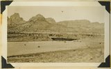
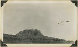
Vermilion Cliffs at Short Creek, 1936.
1936
Image
uum_map
780
View from Great Arch Trail, Zion
1959-06-25
Image
uum_map
781
View from the top of the Hurricane Fault (La Verkin Hill), showing Pine Valley Mountain in the distance; the Vermillion Cliff formation in the middle distance, which is the same formation as Zion only much lower on the west side of the Hurricane Fault.
1930; 1931; 1932; 1933; 1934; 1935; 1936; 1937
Image
uum_map
782
View looking across valley of Little Creek. Shinarump capped cliffs along stream. Smithsonian Butte (left). Navajo Cliffs of Zion Park north across Virgin River. Washington County, Utah, 1937.
1937
Image
uum_map
783
View looking down Virgin River from Hornet Point, towers of Zion National Park in distance. Washington County, UT, 1940
1940
Image
uum_map
784
View looking north across Virgin River at Rockville. Foreground, Moenkopi capped by Shinarump; middle distance, Chinle; distance, Navajo forming Mount Kinesava. Washington County, Utah, 1936.
1936
Image
uum_map
785
View looking north from Pace Knoll (lava) near Deadman Gulch, showing tilted strata east of Hurricane Cliffs (extreme left). Virgin member of Moenkopi, Shinarump conglomerate and Chinle sandstones make hogbacks. Horse Ranch knoll, Navajo and Carmel in upper right, Washington County, UT, 1941
1941
Image
uum_map
786
View looking S-SW from foothills 2 miles west of Virgin City. Shnabkaib member of Moenkopi (foreground). Timpoweap member of Moenkopi into which Timpoweap Canyon of the Virgin River is cut (middle distance). Sugar Loaf and other lava capped mesas (left distance)' crest of Hurricane Cliffs (right distance), Washington County, UT, 1938
1938
Image
uum_map
787
View looking south-southwest across Timpoweap Canyon (center) to crest of Hurricane Cliffs (skyline). Floor chiefly the surface of east dipping beds of Timpoweap member of the Moenkopi. Lava capped mesas of upper Moenkopi (left distance). West of Virgin City. Washington County, UT. 1939
1939
Image
uum_map
788
View looking up Virgin River from a point 2 miles west of Virgin City, valley floor lower Moenkopi. Virgin member caps mesa(front ). Shinarump the terraces upstream. Navajo sandstone of South Mountain (right). Kinesawa Mountain (left) on skyline, Washington County, UT. 1939
1939
Image
uum_map
789
View looking west across valley cut in top Jurassic and Tropic shale (Cretaceous) at head of La Verkin Creek. In distance Timber top and other mesas of Navajo sandstone that form Hurrican Cliffs, Washington County, Utah, 1937.
1937
Image
uum_map
790
View looking west toward buttes of Moenkopi capped by lava between Hurricane Cliffs and Workman Wash (foreground). Washington County, UT, 1939
1939
Image
uum_map
791
View of a branch of the Hurricane Fault showing tilted block on the left which tipped over between the forks with the main fault. Visible from highway at the summit of La Verkin Hill. Lava flow on top and sides of tilted block on left side of picture.
1930; 1931; 1932; 1933; 1934; 1935; 1936; 1937
Image
uum_map
792
View of Oak Valley from west. Carmel white (foreground), Tropic shale overlain by landslides (middle distance), Straight Cliffs sandstone (cliffs), Wasatch cliffs on skyline, Washington County, UT, 1939
1939
Image
uum_map
793
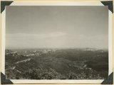
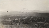
View of St. George from above on hillside, circa 1920
1918; 1919; 1920; 1921; 1922
uum_map
794
View of St. George from the balcony of the St. George Tabernacle.
1941
Image
uum_map
795
View of St. George from the North.
1909-09-16
uum_map
796
View of the St. George Temple from Rio Virgin.
1909-09-11
uum_map
797
View of the St. George Temple from the South.
1941
Image
uum_map
798
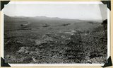
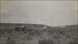
View of the Virgin River a few miles below the mouth of Zion Canyon, showing washed-out banks where farms once stood. Village of Grafton on the opposite side was once the center of a farming area.
1930; 1931; 1932; 1933; 1934; 1935; 1936; 1937
Image
uum_map
799
View southeastward across North Creek to Cougar Mountain; the towers in Zion Park (top left) and Smithsonian Butte (top right); canyon outlined by Shinarump conglomerate. Washington County, UT, 1940
1940
Image
uum_map
800
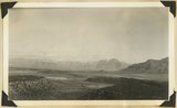
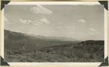
Village of Hurricane, Utah, from Hurricane Hill. Cinder cones in middle distance. Pine Valley Mountain on horizon. Fertility in foreground.
1930; 1931; 1932; 1933; 1934; 1935; 1936; 1937
Image
uum_map
776
-
800
of
977
<
27
28
29
30
31
32
33
34
35
36
>