Home
Browse
Ask Us
Chat
Harmful Language Statement
Log in
Advanced Search
Year
1847
1848
1849
1850
1851
1852
1853
1854
1855
1856
1857
1858
1859
1860
1861
1862
1863
1864
1865
1866
1867
1868
1869
1870
1871
1872
1873
1874
1875
1876
1877
1878
1879
1880
1881
1882
1883
1884
1885
1886
1887
1888
1889
1890
1891
1892
1893
1894
1895
1896
1897
1898
1899
1900
1901
1902
1903
1904
1905
1906
1907
1908
1909
1910
1911
1912
1913
1914
1915
1916
1917
1918
1919
1920
1921
1922
1923
1924
1925
1926
1927
1928
1929
1930
1931
1932
1933
1934
1935
1936
1937
1938
1939
1940
1941
1942
1943
1944
1945
1946
1947
1948
1949
1950
1951
1952
1953
1954
1955
1956
1957
1958
1959
1960
1961
1962
1963
1964
1965
1966
1967
1968
1969
1970
1971
1972
1973
1974
1975
1976
1977
1978
1979
1980
1981
1982
1983
1984
1985
1986
1987
1988
1989
1990
1991
1992
1993
1994
1995
1996
1997
1998
1999
2000
2001
2002
2003
2004
2005
2006
2007
2008
2009
2010
TO
1847
1848
1849
1850
1851
1852
1853
1854
1855
1856
1857
1858
1859
1860
1861
1862
1863
1864
1865
1866
1867
1868
1869
1870
1871
1872
1873
1874
1875
1876
1877
1878
1879
1880
1881
1882
1883
1884
1885
1886
1887
1888
1889
1890
1891
1892
1893
1894
1895
1896
1897
1898
1899
1900
1901
1902
1903
1904
1905
1906
1907
1908
1909
1910
1911
1912
1913
1914
1915
1916
1917
1918
1919
1920
1921
1922
1923
1924
1925
1926
1927
1928
1929
1930
1931
1932
1933
1934
1935
1936
1937
1938
1939
1940
1941
1942
1943
1944
1945
1946
1947
1948
1949
1950
1951
1952
1953
1954
1955
1956
1957
1958
1959
1960
1961
1962
1963
1964
1965
1966
1967
1968
1969
1970
1971
1972
1973
1974
1975
1976
1977
1978
1979
1980
1981
1982
1983
1984
1985
1986
1987
1988
1989
1990
1991
1992
1993
1994
1995
1996
1997
1998
1999
2000
2001
2002
2003
2004
2005
2006
2007
2008
2009
2010
Type
Image
483
Image/StillImage
279
Text
52
Sound
46
Image/MovingImage
3
Format
image/jpeg
833
application/pdf
78
audio/mpeg
30
video/mp4
19
Collection
Beckwith Photograph Collection
45
College of Law Publications
1
Hiram B. Clawson Papers
4
Home Movie Collection
3
Jacob Myers Sr. Papers, 1801-2009
1
Photo Archives
611
Ski and Snow Sports Archives
13
UAIDA Main Collection
19
Uintah County Regional History Center...
1
Utah Humanities Research Foundation
23
Utah Quilt Heritage Records
6
Utah River Running Photo Archives
164
Western Soundscape
46
Western Waters NEH
16
Westminster University Photographs
24
More
Filters:
Spatial Coverage:
"Washington County (Utah)"
626
-
650
of
977
<
21
22
23
24
25
26
27
28
29
30
>
Gallery view
Number of results to display per page
10
25
50
100
200
Sort by Relevance
Sort by Title A-Z
Sort by Title Z-A
Sort by Date Ascending
Sort by Date Descending
Sort by Last Modified Ascending
Sort by Last Modified Descending
Title
Date
Type
Setname
626
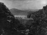
Settlers building the Enterprise Dam in southwestern Utah, ca. 1910.
1910
Image
uum_map
627
Seven Sisters quilt, by Lorraine Elder Pennington
1930; 1931; 1932; 1933; 1934; 1935; 1936; 1937; 1938; 1939
Text
uum_uqhr
628
Shale formation where fossils are found. Near the Pine Creek bridge at the base of the switchboard on new Mt. Carmel road, Zion Canyon.
1930; 1931; 1932; 1933; 1934; 1935; 1936; 1937
Image
uum_map
629
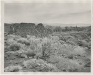
Shebit Indian School
Image
wc_pc
630
Shinarump conglomerate at mouth of Parunuweap Canyon, Washington County, Utah, 1936.
1936
Image
uum_map
631
Shivwits home; Santa Clara, Washington County, Utah
1936
Image/StillImage
uaida_main
632
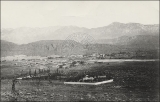
Shivwits Indian Agency and School
1920-05-20
Image
wc_pc
633
Shivwits Indian School
1918-11-29
Image
wc_pc
634
Shnabkaib member (left) and upper red beds of Moenkopi formation, Taylor Creek. Washington County, UT, 1940
1940
Image
uum_map
635
Shoal Creek Dam : Equalizing reservoir no. 1 on Shoal Creek [and] Equalizing reservoir no. 2 on Shoal Creek
1930; 1931; 1932
Image/StillImage
uum_map
636
Shoal Creek Dam : Excavation for Shoal Creek diversion dam above Enterprise [and] The same after dam was finally completed
1930; 1931; 1932
Image/StillImage
uum_map
637
Shoal Creek Dam : Looking up stream through spillway of Shoal Creek diversion dam [and] The same looking down stream
1930; 1931; 1932
Image/StillImage
uum_map
638
Side canyon from highway in Zion National Park
1974-04-16
Image
uum_map
639
Silver Reef graveyard
1950; 1951; 1952; 1953; 1954; 1955; 1956; 1957; 1958; 1959; 1960
Image
uum_map
640
Silver Reef, 1951
1951
Image
uum_map
641
Silver Reef, 1951
1951
Image
uum_map
642
Silver Reef, Washington Co., Utah. Given to RJ [Rufus Johnson?] by Mr. Pendleton, whose childhood was spent at Silver Reef.
1890; 1891; 1892; 1893; 1894; 1895; 1896; 1897; 1898; 1899; 1900; 1901; 1902; 1903; 1904; 1905; 1906; 1907; 1908; 1909; 1910; 1911; 1912; 1913; 1914; 1915; 1916; 1917; 1918; 1919; 1920; 1921; 1922; 1923; 1924; 1925; 1926; 1927; 1928; 1929; 1930; 1931; 1932; 1933; 1934; 1935; 1936; 1937; 1938; 1939; ...
uum_map
643
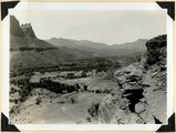
Site of Springdale, Virgin River Valley, below mouth of Zion Canyon. At left, the Watchman. Navajo sandstone, underlaid by Chinle: middle cliff is Springdale member. Washington County, UT
1937; 1938
Image
uum_map
644
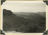
Smith Mesa viewed from the northeast, mesa top developed on Springdale member of the Chinle formation; upper Chinle and Navajo (right), La Verkin Canyon (left), Hurricane Cliffs (on skyline)
1940
Image
uum_map
645
Smithsonian Butte from north base. Chinle, including Springdale member (middle ledge), Wingate? and Kayenta?, Navajo top. Washington County, UT
1937; 1938
Image
uum_map
646
Some animal
1931
Image
dc_bpc
647
Some musical reminiscences of Dixie
1905-04-29
Text
uum_uhrf
648
South from Angels Landing trailhead
1959-06-24
Image
uum_map
649
South wall of Timpoweap Canyon near mouth of Alkali Wash. Kaibab limestone (base), two beds of conglomerate separated by erosion surface, Moenkopi limestone top, Washington County, UT. 1939
1939
Image
uum_map
650
Southern Utah, 1920: Paiute infant in cradleboard, Pine Valley
1920-08
Image/StillImage
uum_map
626
-
650
of
977
<
21
22
23
24
25
26
27
28
29
30
>