Home
Browse
Ask Us
Chat
Harmful Language Statement
Log in
Advanced Search
Year
1847
1848
1849
1850
1851
1852
1853
1854
1855
1856
1857
1858
1859
1860
1861
1862
1863
1864
1865
1866
1867
1868
1869
1870
1871
1872
1873
1874
1875
1876
1877
1878
1879
1880
1881
1882
1883
1884
1885
1886
1887
1888
1889
1890
1891
1892
1893
1894
1895
1896
1897
1898
1899
1900
1901
1902
1903
1904
1905
1906
1907
1908
1909
1910
1911
1912
1913
1914
1915
1916
1917
1918
1919
1920
1921
1922
1923
1924
1925
1926
1927
1928
1929
1930
1931
1932
1933
1934
1935
1936
1937
1938
1939
1940
1941
1942
1943
1944
1945
1946
1947
1948
1949
1950
1951
1952
1953
1954
1955
1956
1957
1958
1959
1960
1961
1962
1963
1964
1965
1966
1967
1968
1969
1970
1971
1972
1973
1974
1975
1976
1977
1978
1979
1980
1981
1982
1983
1984
1985
1986
1987
1988
1989
1990
1991
1992
1993
1994
1995
1996
1997
1998
1999
2000
2001
2002
2003
2004
2005
2006
2007
2008
2009
2010
TO
1847
1848
1849
1850
1851
1852
1853
1854
1855
1856
1857
1858
1859
1860
1861
1862
1863
1864
1865
1866
1867
1868
1869
1870
1871
1872
1873
1874
1875
1876
1877
1878
1879
1880
1881
1882
1883
1884
1885
1886
1887
1888
1889
1890
1891
1892
1893
1894
1895
1896
1897
1898
1899
1900
1901
1902
1903
1904
1905
1906
1907
1908
1909
1910
1911
1912
1913
1914
1915
1916
1917
1918
1919
1920
1921
1922
1923
1924
1925
1926
1927
1928
1929
1930
1931
1932
1933
1934
1935
1936
1937
1938
1939
1940
1941
1942
1943
1944
1945
1946
1947
1948
1949
1950
1951
1952
1953
1954
1955
1956
1957
1958
1959
1960
1961
1962
1963
1964
1965
1966
1967
1968
1969
1970
1971
1972
1973
1974
1975
1976
1977
1978
1979
1980
1981
1982
1983
1984
1985
1986
1987
1988
1989
1990
1991
1992
1993
1994
1995
1996
1997
1998
1999
2000
2001
2002
2003
2004
2005
2006
2007
2008
2009
2010
Type
Image
483
Image/StillImage
279
Text
52
Sound
46
Image/MovingImage
3
Format
image/jpeg
833
application/pdf
78
audio/mpeg
30
video/mp4
19
Collection
Beckwith Photograph Collection
45
College of Law Publications
1
Hiram B. Clawson Papers
4
Home Movie Collection
3
Jacob Myers Sr. Papers, 1801-2009
1
Photo Archives
611
Ski and Snow Sports Archives
13
UAIDA Main Collection
19
Uintah County Regional History Center...
1
Utah Humanities Research Foundation
23
Utah Quilt Heritage Records
6
Utah River Running Photo Archives
164
Western Soundscape
46
Western Waters NEH
16
Westminster University Photographs
24
More
Filters:
Spatial Coverage:
"Washington County (Utah)"
576
-
600
of
977
<
19
20
21
22
23
24
25
26
27
28
>
Gallery view
Number of results to display per page
10
25
50
100
200
Sort by Relevance
Sort by Title A-Z
Sort by Title Z-A
Sort by Date Ascending
Sort by Date Descending
Sort by Last Modified Ascending
Sort by Last Modified Descending
Title
Date
Type
Setname
576
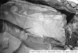
Rock art, Santa Clara [3]
1931
Image
dc_bpc
577
Rock art? (Inscriptions at Santa Clara) [1]
1931
Image
dc_bpc
578
Rock art? (Inscriptions at Santa Clara) [2]
1931
Image
dc_bpc
579
Rock art? (Inscriptions at Santa Clara) [3]
1931
Image
dc_bpc
580
Rock art? (Inscriptions, Santa Clara) [4]
1931
Image
dc_bpc
581
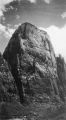
Rock formation
Image
dc_bpc
582
Rockville 1936
1936
Image
uum_map
583
Rockville, Utah, circa 1910
1908; 1909; 1910; 1911; 1912
uum_map
584
Rockville, Utah, circa 1920
1918; 1919; 1920; 1921; 1922
uum_map
585
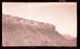
Row of basalt capped Moenkopi mesas near the crest of Hurricane Cliffs south of Hurricane; Sugar loaf in lower right; Pine Valley Mountain. Washington County, Utah, 1937.
1937
Image
uum_map
586
Rufus D. Johnson, age 25?
1890; 1891; 1892; 1893; 1894; 1895; 1896; 1897; 1898; 1899; 1900; 1901; 1902; 1903; 1904; 1905; 1906; 1907; 1908; 1909; 1910; 1911; 1912; 1913; 1914; 1915; 1916; 1917; 1918; 1919; 1920; 1921; 1922; 1923; 1924; 1925; 1926; 1927; 1928; 1929; 1930; 1931; 1932; 1933; 1934; 1935; 1936; 1937; 1938; 1939; ...
uum_map
587
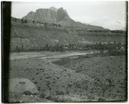
Rufus Johnson on a horse with Sugar Loaf in the background.
1909-09-10
uum_map
588
Rufus Johnson viewing St. George by horseback from Black Ridge.
1909-09-15
uum_map
589
Rufus Johnson with "picture rocks on Black Ridge."
1909-09
uum_map
590
Rufus Johnson with "picture rocks on Black Ridge."
1909-09
uum_map
591
Ruins of Pioneer home
1976-07-13
Image/StillImage
uum_map
592
Saint George, Utah and surroundings
1937; 1938; 1939; 1940; 1941; 1942; 1943; 1944; 1945; 1946; 1947; 1948; 1949; 1950; 1951; 1952; 1953; 1954; 1955; 1956; 1957; 1958; 1959; 1960; 1961; 1962; 1963; 1964; 1965; 1966; 1967; 1968; 1969; 1970; 1971; 1972; 1973; 1974; 1975; 1976; 1977; 1978; 1979; 1980
Image
uum_map_rr
593
Saint George, Utah and surroundings
1937; 1938; 1939; 1940; 1941; 1942; 1943; 1944; 1945; 1946; 1947; 1948; 1949; 1950; 1951; 1952; 1953; 1954; 1955; 1956; 1957; 1958; 1959; 1960; 1961; 1962; 1963; 1964; 1965; 1966; 1967; 1968; 1969; 1970; 1971; 1972; 1973; 1974; 1975; 1976; 1977; 1978; 1979; 1980
Image
uum_map_rr
594
Sally Rice Snow
1920-05-20
Image
wc_pc
595
Same as 2738. Walls and towers of Navajo sandstone; Chinle formation on slopes
1940
Image
uum_map
596
Same as 795 (Row of basalt capped Moenkopi mesas near the crest of Hurricane Cliffs south of Hurricane; Sugar loaf in lower right; Pine Valley Mountain) but showing also in foreground Workman Wash border by low cliffs of Virgin limestone, Moenkopi. Washington County, Utah, 1937.
1937
Image
uum_map
597
Same as G717 [Perched potholes in Navajo sandstone Pine Creek, Zion National Park, Utah, 1932.]
1932
Image
uum_map
598
Same as G717 [Perched potholes in Navajo sandstone Pine Creek, Zion National Park, Utah, 1932.]
1932
Image
uum_map
599
Same as G717 [Perched potholes in Navajo sandstone Pine Creek, Zion National Park, Utah, 1932.]
1932
Image
uum_map
600
Same as G717 [Perched potholes in Navajo sandstone Pine Creek, Zion National Park, Utah, 1932.]
1932
Image
uum_map
576
-
600
of
977
<
19
20
21
22
23
24
25
26
27
28
>