Home
Browse
Ask Us
Chat
Harmful Language Statement
Log in
Photo Archives
Advanced Search
About
Over 70,000 photos covering a variety of topics from Marriott Library Special Collections
Year
1915
1916
1917
1918
1919
1920
1921
1922
1923
1924
1925
1926
1927
1928
1929
1930
1931
1932
1933
1934
1935
1936
1937
1938
TO
1915
1916
1917
1918
1919
1920
1921
1922
1923
1924
1925
1926
1927
1928
1929
1930
1931
1932
1933
1934
1935
1936
1937
1938
Type
Image
174
Format
image/jpeg
172
application/pdf
2
Collection
Photo Archives
174
Filters:
Collection Name:
"Herbert E. Gregory"
Date:
"1922"
1
-
25
of
174
<
1
2
3
4
5
6
7
>
Gallery view
Number of results to display per page
10
25
50
100
200
Sort by Relevance
Sort by Title A-Z
Sort by Title Z-A
Sort by Date Ascending
Sort by Date Descending
Sort by Last Modified Ascending
Sort by Last Modified Descending
Title
Date
Type
1
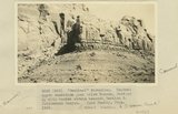
"Sentinel formation." Contact upper sandstone Section A with banded portion beneath, Section B. Cottonwood Canyon. Kane County, UT. 1922
1922
Image
2
"Sentinel formation." Section B banded strata below heavy sandstone. Kaiparowitz region. Kane County, UT. 1922
1922
Image
3
"Sentinel formation." Section B banded strata below heavy sandstone. Kaiparowitz region. Kane County, UT. 1922
1922
Image
4
'"Sentinel formation." Contact upper sandstone just below Dakota, Section A, with banded strata beneath, Section B. Cottonwood Canyon. Kane County, UT. 1922
1922
Image
5
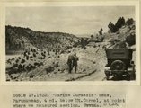
'Marine Jurassic' beds, Paunuweap, 4 miles below Mt. Carmel., at point where we measured section. UT
1922
Image
6
[Faulting in rock layers, probably Kanab Creek Canyon, Arizona, 1922]
1922
Image
7
Abandoned Logan, San Juan River, 10 miles above mouth
1920; 1921; 1922; 1923; 1924; 1925; 1926; 1927; 1928; 1929; 1930
Image
8
Arch Canyon, Coconino over Supai
1920; 1921; 1922; 1923; 1924; 1925; 1926; 1927; 1928; 1929; 1930
Image
9
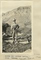
Arthur Lewis. Kanab Camp, UT. 1922
1922
Image
10
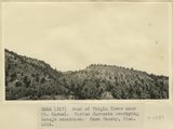
Bank of Virgin River near Mt. Carmel. Marine Jurassic overlying Navajo sandstone. Kane County, UT. 1922
1922
Image
11
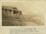
Bank of Virgin River. Road cut in Pliocene(?) wash deposits. 4 miles south of Littlefield. Mojave County, AZ. 1922
1922
Image
12
Base of Kaibab limestone and summit of Hermit Shale in Kaibab (Buckskin) Gulch. Coconino sandstone absent
1922
Image
13
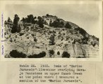
Beds of 'Marine Jurassic' limestone overlying Navajo Sandstone on upper Kanab Creek at the point where Dr. Gregory measured a section of the 'Marine Jurassic' in 1922.
1922
Image
14
Bench along Colorado River formed by soft beds at the horizon of the 'Marine Jurassic'. The view was taken looking up Colorado River from a point about 2 miles west of Kane Creek. Cliffs in background are Sentinel(?) formation and McElmo
1922
Image
15
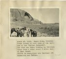
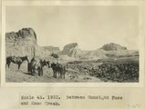
Between Gunsight Pass and Kane Creek
1922
Image
16
Bluffs at Bluff, UT
1920; 1921; 1922; 1923; 1924; 1925; 1926; 1927; 1928; 1929; 1930
Image
17
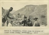
Breakfast. First camp in canyon of lower Kanab Creek, AZ. 1922
1922
Image
18
Bryce Canyon, 1922
1922
Image
19
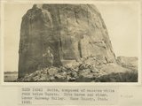
Butte, composed of massive white rock below Dakota. Note horse and rider. Lower Wahweap Valley. Kane County, UT. 1922
1922
Image
20
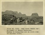
Camp above Meskin Bar on summit of navajo sandstone. Buttes in background are on south side of Colorado
1922
Image
21
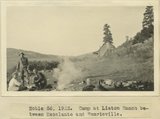
Camp at Liston Ranch between Escalante and Henrieville
1922
Image
22
Camp at Reservoir 2 miles south of Fredonia. Dr. and Mrs. Noble and three packers. Coconino County, AZ. 1922
1922
Image
23
Camp in canyon of Paria Creek in white Navajo sandstone. Dorthy and Dinah Watts
1922
Image
24
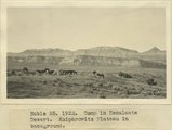
Camp in Escalante Desert. Kaiparowitz Plateau in background
1922
Image
25
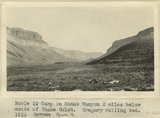
Camp in Kanab Canyon 2 miles below mouth of Snake Gulch. Gregory rolling bed. AZ. 1922
1922
Image
1
-
25
of
174
<
1
2
3
4
5
6
7
>