Home
Browse
Ask Us
Chat
Harmful Language Statement
Log in
Advanced Search
Year
1830
1831
1832
1833
1834
1835
1836
1837
1838
1839
1840
1841
1842
1843
1844
1845
1846
1847
1848
1849
1850
1851
1852
1853
1854
1855
1856
1857
1858
1859
1860
1861
1862
1863
1864
1865
1866
1867
1868
1869
1870
1871
1872
1873
1874
1875
1876
1877
1878
1879
1880
1881
1882
1883
1884
1885
1886
1887
1888
1889
1890
1891
1892
1893
1894
1895
1896
1897
1898
1899
1900
1901
1902
1903
1904
1905
1906
1907
1908
1909
1910
1911
1912
1913
1914
1915
1916
1917
1918
1919
1920
1921
1922
1923
1924
1925
1926
1927
1928
1929
1930
1931
1932
1933
1934
1935
1936
1937
1938
1939
1940
1941
1942
1943
1944
1945
1946
1947
1948
1949
1950
1951
1952
1953
1954
1955
1956
1957
1958
1959
1960
1961
1962
1963
1964
1965
1966
1967
1968
1969
1970
1971
1972
1973
1974
1975
1976
1977
1978
1979
1980
1981
1982
1983
1984
1985
1986
1987
1988
1989
1990
1991
1992
1993
1994
1995
1996
1997
1998
1999
2000
2001
2002
TO
1830
1831
1832
1833
1834
1835
1836
1837
1838
1839
1840
1841
1842
1843
1844
1845
1846
1847
1848
1849
1850
1851
1852
1853
1854
1855
1856
1857
1858
1859
1860
1861
1862
1863
1864
1865
1866
1867
1868
1869
1870
1871
1872
1873
1874
1875
1876
1877
1878
1879
1880
1881
1882
1883
1884
1885
1886
1887
1888
1889
1890
1891
1892
1893
1894
1895
1896
1897
1898
1899
1900
1901
1902
1903
1904
1905
1906
1907
1908
1909
1910
1911
1912
1913
1914
1915
1916
1917
1918
1919
1920
1921
1922
1923
1924
1925
1926
1927
1928
1929
1930
1931
1932
1933
1934
1935
1936
1937
1938
1939
1940
1941
1942
1943
1944
1945
1946
1947
1948
1949
1950
1951
1952
1953
1954
1955
1956
1957
1958
1959
1960
1961
1962
1963
1964
1965
1966
1967
1968
1969
1970
1971
1972
1973
1974
1975
1976
1977
1978
1979
1980
1981
1982
1983
1984
1985
1986
1987
1988
1989
1990
1991
1992
1993
1994
1995
1996
1997
1998
1999
2000
2001
2002
Type
Image/StillImage
273
Image
217
Text
88
Format
image/jpeg
469
application/pdf
113
Collection
Beckwith Photograph Collection
48
Photo Archives
243
Ski and Snow Sports Archives
127
UAIDA Main Collection
195
Utah Humanities Research Foundation
19
Utah Quilt Heritage Records
50
Utah River Running Photo Archives
13
Western Waters NEH
8
Westminster University Photographs
4
More
Filters:
Spatial Coverage:
"Iron County (Utah)"
426
-
450
of
707
<
13
14
15
16
17
18
19
20
21
22
>
Gallery view
Number of results to display per page
10
25
50
100
200
Sort by Relevance
Sort by Title A-Z
Sort by Title Z-A
Sort by Date Ascending
Sort by Date Descending
Sort by Last Modified Ascending
Sort by Last Modified Descending
Title
Date
Type
Setname
426
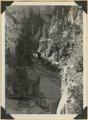
Natural Bridge - Cedar Canyon
1907; 1908; 1909; 1910; 1911; 1912; 1913; 1914; 1915; 1916; 1917; 1918; 1919; 1920; 1921; 1922; 1923; 1924; 1925; 1926; 1927; 1928; 1929; 1930; 1931; 1932; 1933; 1934; 1935
Image/StillImage
uum_map
427
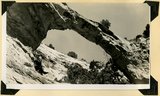
Natural bridge near top of wall of Ashdown Canyon, Iron County, UT, 1941
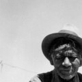
1941
Image
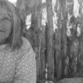
uum_map
428
Near west edge of Kolob Terrace, looking northeast across mouth of Coal Creek; tilted rocks at Hurricane fault (middle); Cedar City, lower left. Iron County, UT
1937; 1938
Image
uum_map
429
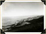
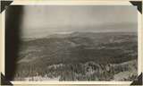
North Rim of canyon, Wasatch limestone. Iron Mountain in distance west. Cedar Breaks National Monument
1937; 1938
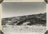
Image
uum_map
430
Old documents (deeds, notices of appointment, etc.) found in the old secretary of William Davenport of Parowan
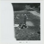
1873; 1881; 1882; 1884; 1885; 1886; 1890; 1891; 1893
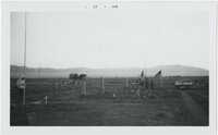
Text
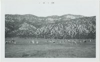
uum_uhrf
431
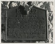
Old Irontown plaque
1945; 1946; 1947; 1948; 1949; 1950; 1951; 1952; 1953; 1954; 1955; 1956; 1957; 1958; 1959; 1960; 1961; 1962; 1963; 1964; 1965
Image
uum_map
432
Old Mary; Cedar City, Iron County, Utah
1936
Image/StillImage
uaida_main
433
Old Mose; Cedar City, Iron County, Utah
1936
Image/StillImage
uaida_main
434
Old Sarah Frank; Cedar City, Iron County, Utah
1936
Image/StillImage
uaida_main
435
Old Sarah Frank; Cedar City, Iron County, Utah
1936
Image/StillImage
uaida_main
436
Old scraps patchwork quilt by Alice Boone Page
1923
Text
uum_uqhr
437
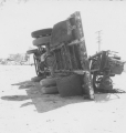
Overturned truck. (Johnson covered this open-air test in Nevada for radio station KSUB of Cedar City, Utah.)
1952-04-22
Image
uum_map
438
Paiute entertainers at Thanksgiving dinner; Cedar City, Iron County, Utah
1950
Image/StillImage
uaida_main
439
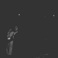
Paiute musicians making music with notched sticks and upturned washtub; Cedar City, Iron County, Utah
1936
Image/StillImage
uaida_main
440
Paiutes dancing; Cedar City, Iron County, Utah
Image/StillImage
uaida_main
441
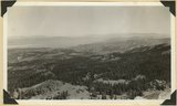
Panorama northwest of Brian Head, Markagunt Plateau. Glacial topography foreground; Wasatch formation (middle distance); Little Salt Lake in valley beyond Hurricane Cliffs. Iron County, UT
1937; 1938
Image
uum_map
442
Panorama northwest of Brian Head, Markagunt Plateau. Glacial topography foreground; Wasatch formation (middle distance); Little Salt Lake in valley beyond Hurricane Cliffs. Iron County, UT
1937; 1938
Image
uum_map
443
Panorama of Ashdown Canyon, 600-1800 feet deep, 20-150 feet wide out in Straight Cliffs sandstone. Iron County, UT, 1941
1941
Image
uum_map
444
Panorama of Ashdown Canyon, 600-1800 feet deep, 20-150 feet wide out in Straight Cliffs sandstone. Iron County, UT, 1941
1941
Image
uum_map
445
Panorama. Surface of Kolob Terrace near the head of Kolob Creek. Iron County, UT
1941; 1942
Image
uum_map
446
Panorama. Surface of Kolob Terrace near the head of Kolob Creek. Iron County, UT
1941; 1942
Image
uum_map
447
Paragonah Cemetery [01]
1963
Image/StillImage
uum_map
448
Paragonah Cemetery [02]
1963
Image/StillImage
uum_map
449
Paragonah Cemetery [03]
1963
Image/StillImage
uum_map
450
Paragonah Cemetery [04]
1963
Image/StillImage
uum_map
426
-
450
of
707
<
13
14
15
16
17
18
19
20
21
22
>