Home
Browse
Ask Us
Chat
Harmful Language Statement
Log in
Advanced Search
Year
1845
1846
1847
1848
1849
1850
1851
1852
1853
1854
1855
1856
1857
1858
1859
1860
1861
1862
1863
1864
1865
1866
1867
1868
1869
1870
1871
1872
1873
1874
1875
1876
1877
1878
1879
1880
1881
1882
1883
1884
1885
1886
1887
1888
1889
1890
1891
1892
1893
1894
1895
1896
1897
1898
1899
1900
1901
1902
1903
1904
1905
1906
1907
1908
1909
1910
1911
1912
1913
1914
1915
1916
1917
1918
1919
1920
1921
1922
1923
1924
1925
1926
1927
1928
1929
1930
1931
1932
1933
1934
1935
1936
1937
1938
1939
1940
1941
1942
1943
1944
1945
1946
1947
1948
1949
1950
1951
1952
1953
1954
1955
1956
1957
1958
1959
1960
1961
1962
1963
1964
1965
1966
1967
1968
1969
1970
1971
1972
1973
1974
1975
1976
1977
1978
1979
1980
1981
1982
1983
1984
1985
1986
1987
1988
1989
1990
1991
1992
1993
1994
1995
1996
1997
1998
TO
1845
1846
1847
1848
1849
1850
1851
1852
1853
1854
1855
1856
1857
1858
1859
1860
1861
1862
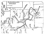
1863
1864
1865
1866
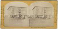
1867
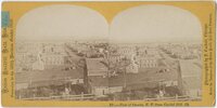
1868
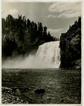
1869
1870
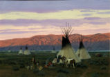
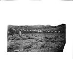
1871
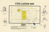
1872
1873
1874
1875
1876
1877
1878
1879
1880
1881
1882
1883
1884
1885
1886
1887
1888
1889
1890
1891
1892
1893
1894
1895
1896
1897
1898
1899
1900
1901
1902
1903
1904
1905
1906
1907
1908
1909
1910
1911
1912
1913
1914
1915
1916
1917
1918
1919
1920
1921
1922
1923
1924
1925
1926
1927
1928
1929
1930
1931
1932
1933
1934
1935
1936
1937
1938
1939
1940
1941
1942
1943
1944
1945
1946
1947
1948
1949
1950
1951
1952
1953
1954
1955
1956
1957
1958
1959
1960
1961
1962
1963
1964
1965
1966
1967
1968
1969
1970
1971
1972
1973
1974
1975
1976
1977
1978
1979
1980
1981
1982
1983
1984
1985
1986
1987
1988
1989
1990
1991
1992
1993
1994
1995
1996
1997
1998
Type
Image/StillImage
419
Text
1
Format
image/jpeg
356
application/pdf
40
Collection
Al W. Morton Collection, 1930s-1950s
4
American Westward Migration
5
Classified Photographs
66
Photo Archives
125
Regional History Center
2
Ski and Snow Sports Photo Archives
100
Theater Programs Collection, 1866-1995
1
UAIDA Main Collection
62
Uintah County Regional History Center...
21
Utah Artists Project
2
Utah River Running Photo Archives
31
More
Filters:
Spatial Coverage:
"Wyoming"
Type:
"Image/StillImage"
176
-
200
of
419
<
3
4
5
6
7
8
9
10
11
12
>
Gallery view
Number of results to display per page
10
25
50
100
200
Sort by Relevance
Sort by Title A-Z
Sort by Title Z-A
Sort by Date Ascending
Sort by Date Descending
Sort by Last Modified Ascending
Sort by Last Modified Descending
Title
Date
Type
Setname
176
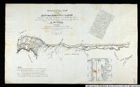
Topographical Map of the Road From Missouri To Oregon Commencing at the Mouth of the Kansas in the Missouri River and Ending at the Mouth of the Wallah-Wallah in the Columbia. Section 3
1846
Image/StillImage
uu_awm
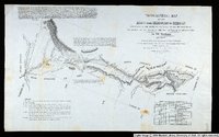
177
Topographical Map of the Road From Missouri To Oregon Commencing at the Mouth of the Kansas in the Missouri River and Ending at the Mouth of the Wallah-Wallah in the Columbia. Section 4
1846
Image/StillImage
uu_awm
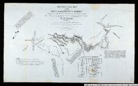
178
Topographical Map of the Road From Missouri To Oregon Commencing at the Mouth of the Kansas in the Missouri River and Ending at the Mouth of the Wallah-Wallah in the Columbia. Section 5
1846
Image/StillImage
uu_awm
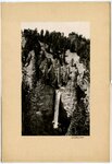
179
Tower Falls
1930; 1931; 1932; 1933; 1934; 1935; 1936; 1937; 1938; 1939; 1940
Image/StillImage
uum_map
180
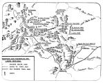
Trappers and Traders in Ute Lands 1820-1844
Image/StillImage
uaida_main
181
Uintah Railway Elevation Map 1930
1930
Image/StillImage
ucl_maps
182
Unidentified man at Byron, Wyoming
1907; 1908; 1909; 1910; 1911; 1912; 1913; 1914; 1915; 1916; 1917; 1918; 1919; 1920; 1921; 1922; 1923; 1924; 1925; 1926; 1927; 1928; 1929; 1930; 1931; 1932; 1933; 1934; 1935
Image/StillImage
uum_map
183
Union Pacific Rail Road excursion to the 100th Meridian, October 1866: Burnetizing works of the U.P.R.R. at Omaha.
1866-10
Image/StillImage
uum_map
184
Union Pacific Rail Road excursion to the 100th Meridian, October 1866: Engine house & workshops of the U.P.R.R. at Omaha
1866-10
Image/StillImage
uum_map
185
Union Pacific Rail Road excursion to the 100th Meridian, October 1866: Herndon House, Omaha, N.T.
1866-10
Image/StillImage
uum_map
186
Union Pacific Rail Road excursion to the 100th Meridian, October 1866: View of Omaha, N.T., from Capitol Hill
1866-10
Image/StillImage
uum_map
187
Upper Falls, Yellowstone [01]
1930; 1931; 1932; 1933; 1934; 1935; 1936; 1937; 1938; 1939; 1940
Image/StillImage
uum_map
188
Upper Falls, Yellowstone [02]
1930; 1931; 1932; 1933; 1934; 1935; 1936; 1937; 1938; 1939; 1940
Image/StillImage
uum_map
189
Ute Camp - Southwest Wyoming
1991
Image/StillImage
uu_uap
190
Ute Lands, 1868
Image/StillImage
uaida_main
191
The Utes Journey to South Dakota 1906-1908
Image/StillImage
uaida_main
192
Views of the Rocky Mountains and vicinity: Carmichael's camp in the Black Hills, U.P.R.R.
1868
Image/StillImage
uum_map
193
Views of the Rocky Mountains and vicinity: First rock cut on U.P.R.R. entering the Black Hills
1868
Image/StillImage
uum_map
194
Views of the Rocky Mountains and vicinity: Overland route crossing the summit
1868
Image/StillImage
uum_map
195
Views of the Rocky Mountains and vicinity: Red sand stone rocks, Laramie plains [01]
1868
Image/StillImage
uum_map
196
Views of the Rocky Mountains and vicinity: Red sand stone rocks, Laramie plains [03]
1868
Image/StillImage
uum_map
197
Views of the Rocky Mountains and vicinity: Red sand stone rocks, Laramie plains [04]
1868
Image/StillImage
uum_map
198
Washakie and his band of warriors encamped in the Wind River Mountains, Wyoming, 1870
1870
Image/StillImage
uaida_main
199
Washakie's band and encampment in southern foothills of Wind River Mountains, Wyoming, 1870
1870
Image/StillImage
uaida_main
200
Water supply
1880; 1881; 1882; 1883; 1884; 1885; 1886; 1887; 1888; 1889; 1890; 1891; 1892; 1893; 1894; 1895; 1896; 1897; 1899; 1900; 1901; 1902; 1903; 1904; 1905; 1906; 1907; 1908; 1909; 1910
Image/StillImage
uaida_main
176
-
200
of
419
<
3
4
5
6
7
8
9
10
11
12
>