Home
Browse
Ask Us
Chat
Harmful Language Statement
Log in
Photo Archives
Advanced Search
About
Over 70,000 photos covering a variety of topics from Marriott Library Special Collections
Year
1915
1916
1917
1918
1919
1920
1921
1922
1923
1924
1925
1926
1927
1928
1929
1930
1931
1932
1933
1934
1935
1936
1937
1938
TO
1915
1916
1917
1918
1919
1920
1921
1922
1923
1924
1925
1926
1927
1928
1929
1930
1931
1932
1933
1934
1935
1936
1937
1938
Type
Image
69
Format
image/jpeg
67
application/pdf
2
Collection
Photo Archives
69
Filters:
Collection Name:
"Herbert E. Gregory"
Date:
"1931"
1
-
25
of
69
<
1
2
3
>
Gallery view
Number of results to display per page
10
25
50
100
200
Sort by Relevance
Sort by Title A-Z
Sort by Title Z-A
Sort by Date Ascending
Sort by Date Descending
Sort by Last Modified Ascending
Sort by Last Modified Descending
Title
Date
Type
1
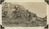
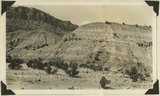
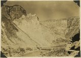
1, Navajo sandstone (at base); 2, shales; 3, sandstone bed that forms "entablatures" on "Temples" of Zion National Park; 4, Carmel and above. Zion-Mount Carmel highway, Kane County, Utah, 1931.
1931
Image
2
Basalt in Moenkopi, north wash.
1930; 1931; 1932; 1933; 1934; 1935; 1936; 1937
Image
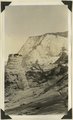
3
Butte eroded from Navajo sandstone, capped by iron concretion, Zion-Mount Carmel highway, Kane County, Utah, 1931.
1931
Image
4
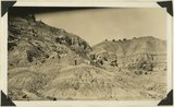
Buttes of Cretaceous sandstone including fossil wood, bones of turtles, and dinosaurs (?) near head of Sheep Creek. Kane County, Utah, 1931.
1931
Image
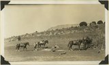
5
Camp in floor of ancient lake bed; mesa of Navajo sandstone in background. Kitchen Rach, Kane County, Utah, 1931.
1931
Image
6
Carmel on Navajo. Head of Parunuweap Canyon.
1930; 1931; 1932; 1933; 1934; 1935; 1936; 1937
Image
7
Chinle formation at "Petrified Forest" near "Sixteen mile Spring," Kane County, Utah, 1931.
1931
Image
8
Chinle formation near Clarks Ranch 10+ miles east of Johnson Canyon. Kane County, Utah, 1931.
1931
Image
9
Cliff dweller niche, base of Navajo sandstone. Zion Park.
1930; 1931; 1932; 1933; 1934; 1935; 1936; 1937
Image
10
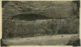
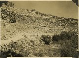
Coalpits volcano north of Grafton.
1930; 1931; 1932; 1933; 1934; 1935; 1936; 1937
Image
11
Colorado River looking down stream from the mouth of Moki Canyon (at the left).
1930; 1931; 1932; 1933; 1934; 1935; 1936; 1937
Image
12
Colorado River looking up stream from the mouth of Moki Canyon.
1930; 1931; 1932; 1933; 1934; 1935; 1936; 1937
Image
13
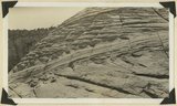
Cross bedding in Navajo sandstone. Zion-Mount Carmel highway, Kane County, Utah, 1931.
1931
Image
14
Crossbedding of sandstone along Mt. Carmel road. Indicating wind action and sand dune formation prior to the formation of rock.
1930; 1931; 1932; 1933; 1934; 1935; 1936; 1937
Image
15
Curvillinear fractures in sandstone, west wall of Temple of Sinawava, Zion Canyon.
1930; 1931; 1932; 1933; 1934; 1935; 1936; 1937
Image
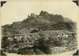
16
Eagle Crags.
1930; 1931; 1932; 1933; 1934; 1935; 1936; 1937
Image
17
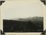
Elkheart Cliffs east of Mt. Carmel.
1930; 1931; 1932; 1933; 1934; 1935; 1936; 1937
Image
18
The Great White Throne, Zion Canyon.
1930; 1931; 1932; 1933; 1934; 1935; 1936; 1937
Image
19
Half Arch. East side of Narrows, Zion Canyon, above Temple of Sinawava.
1930; 1931; 1932; 1933; 1934; 1935; 1936; 1937
Image
20
Herbert E. Gregory Book 10: San Juan, Zion, Capitol Reef, 1915-1938
1915; 1916; 1917; 1918; 1919; 1920; 1921; 1922; 1923; 1924; 1925; 1926; 1927; 1928; 1929; 1930; 1931; 1932; 1933; 1934; 1935; 1936; 1937; 1938
Image
21
Hidden Canyon from Observation Point. A typical hanging canyon or valley.
1930; 1931; 1932; 1933; 1934; 1935; 1936; 1937
Image
22
Hurricane Cliffs looking north from "Toquerville Gap" along line of fault. Kaibab limestone on right; Moenkopi formation (Shnabkaib member) upturned in left foreground. Washington County, Utah, 1931.
1931
Image
23
The Hurricane Fault where it crosses the Virgin River. La Verkin Warm Sulphur Springs in canyon.
1930; 1931; 1932; 1933; 1934; 1935; 1936; 1937
Image
24
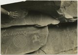
Indian pictographs near Mt. Carmel road.
1930; 1931; 1932; 1933; 1934; 1935; 1936; 1937
Image
25
Lava flow over gravel wash. South of Toquerville, Utah, along main road from Zion Canyon to Anderson's Ranch.
1930; 1931; 1932; 1933; 1934; 1935; 1936; 1937
Image
1
-
25
of
69
<
1
2
3
>