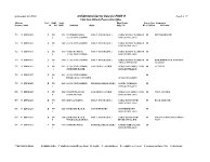
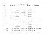
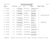
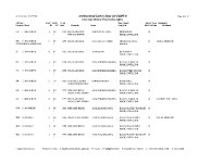
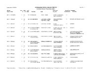
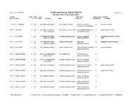
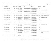
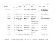
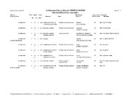
| Spatial Coverage |
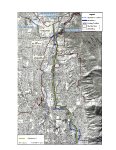
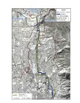
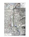
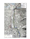
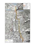
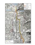
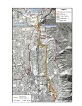
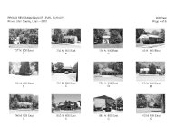
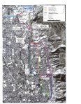
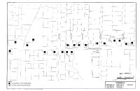
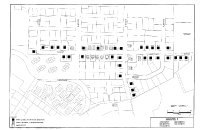
Survey Boundaries: There are two proposed alternatives, Alternative 1 and Alternative 2. All historic properties along all routes were surveyed as areas of potential effect. Beginning on the south end of the APE at 560 North streets were surveyed in the following order: 1200 E, Apple Ave, Locust Ln, 820 No, Birch Ln, Cherry Ln, Fir Ave, 900 E, Timpview Dr, 2200 N, 2320 N, Canyon Rd, University Ave, 3 and the Olmstead Power Plant Grounds. Alternative 1: Begin in the Right of Way of 1200 E at 560 N, thence north to Apple Ave with a slight jog to the east to the intersection of Apple Ave and Cherry Ln. North on Cherry Ln to the curve onto Fir Ave which then intersects 900 E. The Route continues north on 900 E to the curve which becomes 2200 N and continues to the intersection with Timpview Dr. Continuing north on Timpview Dr for a block to the intersection with 2320 N, following that road to a point about 350 E, at which point the route leaves the roadway and travels cross country to a point where it intersects Canyon Rd. Canyon Rd is followed to 140 E and 2680 N where it connects to University Ave. The route then follows University Ave to the various delivery points near the mouth of the Canyon. Option A: At the point of beginning, the route travels north up Seven Peaks Blvd. to a point where it leaves the roadway and travels cross-country to 820 N, where it jogs to the east to the intersection of 820 N and Locust Ln. North on Locust Ln to Apple Ave, and west to the intersection of Cherry Ln. Option B: At the point of intersection between 1200 E and Apple Ave, the route turns slightly to the west on Birch Ln and continues west to the intersection of 900 E. North on 900 E to Fir Ave. Option C: At the intersection of Timpview Dr and 2200 N the route continues on 2000 N to the intersection with Canyon Rd, north on Canyon Rd to the original route. Alternative 2: The same route as Alternative 1, including Options A and B, to the point of intersection with Timpview Drive. From this intersection the route travels north on Timpview Dr to its end at 4525 N. The route travels west on 4525 N to the intersection with University Ave. It is the same as Alternative I from this point on. Alternative 3 is the same route as the no action alternative discussed in the EIS until it reaches 2320 N at the mouth of Rock Canyon. From this point the route of Alternative 3 is west on 2320 N following the curve to the southwest on North Temple Dr to its terminus at 900 E and 2200 N to the connection with Alternative 1. |