| Publication Type |
thesis |
| School or College |
College of Mines & Earth Sciences |
| Department |
Materials Science & Engineering |
| Author |
Condie, Kent C. |
| Title |
Petrogeneis of the Mineral Range Pluton, Southwestern Utah |
| Date |
1960-06 |
| Description |
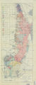
The Mineral Range is located in Beaver and Millard Counties In southwestern Utah. The range is about thirty miles long and averages five miles in width. The southern end of the range can be reached via Utah State Highway 21 which connects the towns of Beaver, Adamsville, Minersville, and Milford; there are many dirt roads which also traverse the range. The purpose of the present Investigation is two-fold: (1) to make a thorough study of the relationship between the Precambrian metamorphic complex on the west side of the Mineral Range and the Mineral Range pluton, and (2) to summarize in detail the petrogenesis of the Mineral Range pluton. Liese (1957) and Earll (1957) have described the sedimentary rocks of the Mineral Range; therefore, only a brief summary of the stratigraphy condensed from these two theses is presented here. The Cambrian is represented by the Prospect Mountain quartzite, Pioche shale, and a series of undifferentiated limestones. The Ordovician and Silurian are missing. Resting on top of the Cambrian is a series of undifferentiated lower Paleozoic limestones and dolomites. Devonian sediments have not been found; the Mississippian is represented by the Topache limestone; the Permian by the Coconino(?) sandstone and Kaibab limestone; the Triassic by the Moenkopi formation; the Jurassic by the Navajo sandstone and Carmel formation; the Cretaceous by the Claron-Indianola conglomerate; and the Recent by lake beds and other alluvium. A Laramide thrust is responsible for the Prospect Mountain quartzite resting on top of middle Cambrian limestones in the northern Mineral Range; also, a zone of cataclastic metamorphism north of Cave Canyon is interpreted by the author as a thrust zone. The southern and southeastern part of the Mineral Range is a homocline with beds dipping southeast and striking northeast. A prominent set of high-angle faults strike east-west in the southern and northern part of the range; north trending Basin and Range faults cut all previous structures. The following list summarizes the igneous rocks recognized in the Mineral Range by the author: (1) rhyolite porphyry dikes and plugs In the southern part of the range, (2) dellenite porphyry dikes in the northern part of the range, (3) lamprophyre (spessartite) dikes along the west side of the range, (4) the Minersville volcanics in the southern part of the range, (5) the Ranch Canyon volcanics in the central part of the range, and (6) Pleistocene and Recent basalt flows found around the borders of the range. All of the igneous rocks with exception of the basalt flows and possibly the Ranch Canyon volcanics are Tertiary in age. The Precambrian (?) gneisses, schists, granodiorites and adamellites along the west side of the range are described and named the Wildhorse Canyon series. Also, an extensive zone of cataclastic metamorphism north of Cave Canyon is described as well as small tactite and skarn zones found around the periphery of the Mineral Range pluton and the Lincoln stock. The Mineral Range pluton is the largest body of granite in the state of Utah. It is over twenty miles long and the maximum width is six miles. The Lincoln stock (adamellite) and its apophyses crop out south of Cave Canyon fault on the west side of the range and are thought to be basic apophyses of the Mineral Range pluton. An extensive ""inclusion zone"" found along the western part of the Mineral Range pluton is described and shown on the geologic map. Also, numerous migmatites, pegmatites, and aplites which were found to be gradational with each other are described. The chief criteria used and accepted by most petrologists to distinguish granitized granite from magmatic granite are presented and applied to the Mineral Range pluton. Those criteria diagnostic of magmatic injection were not found in the pluton while all but two out of thirteen major criteria for granitization were present In the Mineral Range pluton or the Lincoln stock. The tectonic setting of the pluton is evaluated in terms of Misch (I949), and the zone of emplacement Is evaluated in terms of Buddington (1959). The following is a summary of the petrologic and tectonic history of the Mineral Range as interpreted by the author: Precambrian sediments and possibly plutonic rocks were metamorphosed and eroded before Paleozoic time. Paleozoic and Mesozoic deposits are relatively thin (12,000 feet) and for this reason it is believed that this area represents the western margin of the Colorado Plateau. Floods of conglomerate were deposited in this area during Coloradoan time; the area was folded and domed (E. Montanan?) and the Mineral Range pluton was formed (L. Montanan?) during late Cretaceous time; thrusting and cataclastic metamorphism occurred during Paleocene time; lamprophyres, rhyolite and dellenite porphyry dikes were intruded during mid-Tertiary time and east-west high-angle faulting commenced; the Minersville volcanics were deposited and Basin-range faulting commenced in Oligocene time; epeirogeny and erosion and finally deposition of the Ranch Canyon volcanics occurred during Plio-Pleistocene time; basalt flows, lake beds and other alluvium were deposited during Pleistocene and Recent time. |
| Type |
Text; Image |
| Publisher |
University of Utah |
| Subject |
Petrology -- Utah -- Beaver County; Millard County; Geology -- Utah -- Beaver County; Millard County; Mineral Range (Utah) |
| Dissertation Institution |
University of Utah |
| Dissertation Name |
Master of Arts |
| Language |
eng |
| Relation is Version of |
Digital reproduction of Petrogeneis of the Mineral Range Pluton, Southwestern Utah, J. Willard Marriott Library Special Collections, QE 3.5 1960 C65 |
| Rights Management |
In the public domain use of this file is allowed in accordance with the Creative Commons Attribution-Noncommercial-No Derivative Works 3.0 United States License, http://creativecommons.org/licenses/by-nc-nd/3.0/us |
| Format Medium |
application/pdf; image/jpeg |
| Identifier |
us-etd3,8888 |
| Source |
Original: University of Utah J. Willard Marriott Library Special Collections |
| Conversion Specifications |
Text: Original scanned on Epson GT-30000/Epson Expression 836XL as 400 dpi to pdf using ABBYY FineReader 9.0 Professional Edition. Image: Original Scanned on Colortrac Smartlf GxT42 and saved as 300dpi tiff. Final display image generated by CONTENTdm. |
| ARK |
ark:/87278/s65b0h89 |
| Setname |
ir_etd |
| ID |
195422 |
| Reference URL |
https://collections.lib.utah.edu/ark:/87278/s65b0h89 |