| Title |
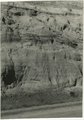
Sevier River formation overlaid by basalt near mouth of Corral Creek on Highway 89, 2 miles east of Panguitch. Garfield County, UT. 1944 |
| Photo Number |
P0013n12_075_2940A |
| Description |
Photo of exposed Sevier River formation overlaid by basalt near the mouth of Corral Creek on U.S. Highway 89 in Garfield County, Utah, 1944. Photograph from Herbert E. Gregory Book 12: Colorado Plateau, Province, 1942-1944 |
| Creator |
Gregory, Herbert E. (Herbert Ernest), 1869-1952 |
| Date |
1944 |
| Textual Date |
1944 |
| Keywords |
Photographs; Black-and-white photographs |
| Subject |
Geology--Utah--Garfield County--Photographs |
| Spatial Coverage |
Garfield County (Utah) |
| Additional Information |
Photograph from Herbert E. Gregory Box 16 Folder 10. Another copy located in Herbert E. Gregory Book 12: Colorado Plateau, Province, 1942-1944 - Scrapbook identifier ark:/87278/s60904br |
| Collection Number and Name |
P0013 Herbert E. Gregory Photograph Collection |
| Collection Name |
Herbert E. Gregory |
| Rights |
 |
| Type |
Image |
| Finding Aid |
http://archiveswest.orbiscascade.org/ark:/80444/xv18865/ |
| Digitization Specifications |
Digital images produced on Epson Expression 10000 XL scanner, 24-bit color at 800 ppi and cropped using Adobe Photoshop CC 2017 (Macintosh). Archival files are uncompressed TIFF. |
| ARK |
ark:/87278/s65t7jtc |
| Setname |
uum_map |
| ID |
1305041 |
| Reference URL |
https://collections.lib.utah.edu/ark:/87278/s65t7jtc |