| OCR Text |
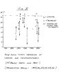
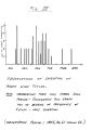
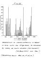
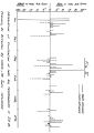
Show 10 A standard barometer is used to trace the movement and variations of low and high pressure systems. A large aerial photo, with clear plastic overlay, is used to record slide occurrence, location, date, time, class, etc. with grease pencil. A separate overlay shows slide history and patterns. The third observation site is the Mt. Baldy Ranger Station. It is located 5 miles south of station # 2 at 4200' elevation. Primary function of this station is the observation of barometric pressure, to forewarn of weather fronts. Also, through the courtesy of the County Flood Control, we have a recording precipitation gauge, readings of which give warning of high precipitation intensities sometimes before they occur at the ski area to the north. Since we are tied in on U. S. Weather Bureau radio network, accurate weather forecasts are received daily on the station radio. The daily newspaper, delivered here, provides weather maps which are helpful in determining what type of influence we might expect. SNOW PROFILES Snow profiles and studies consist primarily of stratigraphic pits at the release zones at Baldy Notch ( 78001) and occasionally at station # 2 ( 65OO1). Pits are dug at level, exposed area, walls are brushed with soft paint brush to bring out strata, and samples of the strata are examined with small magnifying glass for classification as to type and metamorphic stage. A ram- penetrometer could be used here to classify layer hardness. Thickness of layers is measured with upright yard stick or snow stake. Layer temperatures are measured with photo lab dial thermometers, and |