| Title |
Kennecott property facilities removal action site maps [part two] |
| Alternative Title |
sludge |
| File Number |
2107_049_002 |
| File Name |
2107_049_002.pdf |
| Description |
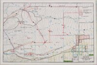
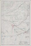
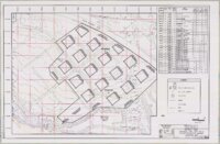
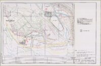
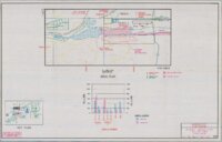
Maps from the mid-1990s cleanup of soils in Kennecott Superfund sites. Five maps are from Kennecott properties in the Herriman and Butterfield Creek Superfund sites, "Appendix G" from the report in Box 28, folders 3 and 4. Five maps show sample sites at Kennecott's Refinery area, "Section 7," location maps from the report in Box 33, folders 3 and 4. Two maps are from unidentified reports. This digital file contains the entire contents of folder 2 from box 49 of the Supefund Records Center records collection. |
| Creator |
Kennecott Corporation |
| Date |
1992; 1996; 1997 |
| Spatial Coverage |
Herriman, Salt Lake County, Utah, United States; Salt Lake County, Utah, United States |
| Subject |
Hazardous waste site remediation--Utah--Salt Lake County--Maps; Soil pollution--Utah--Salt Lake County--Maps; United States. Comprehensive Environmental Response, Compensation, and Liability Act of 1980--Archives |
| Collection Number and Name |
Accn2107 Superfund Records Center records |
| Holding Institution |
Special Collections, J. Willard Marriott Library, University of Utah |
| Finding Aid |
https://archiveswest.orbiscascade.org/ark:80444/xv19958 |
| Type |
Image/StillImage |
| Genre |
reports |
| Format |
application/pdf |
| Language |
eng |
| Rights Management |
This digital file is comprised of multiple documents with varying copyright status. Users are responsible for determining the copyright status of these documents. |
| Rights |
 |
| ARK |
ark:/87278/s6qmk6yj |
| Metadata Cataloger |
Ken Rockwell |
| Setname |
uum_srcr |
| ID |
2627608 |
| Reference URL |
https://collections.lib.utah.edu/ark:/87278/s6qmk6yj |