Home
Browse
Ask Us
Chat
Harmful Language Statement
Log in
Photo Archives
Advanced Search
About
Over 70,000 photos covering a variety of topics from Marriott Library Special Collections
Year
1872
1873
1874
1875
1876
1877
1878
1879
1880
1881
1882
1883
1884
1885
1886
1887
1888
1889
1890
1891
1892
1893
1894
1895
1896
1897
1898
1899
1900
1901
1902
1903
1904
1905
1906
1907
1908
1909
1910
1911
1912
1913
1914
1915
1916
1917
1918
1919
1920
1921
1922
1923
1924
1925
1926
1927
1928
1929
1930
1931
1932
1933
1934
1935
1936
1937
1938
1939
1940
1941
1942
1943
1944
1945
1946
1947
1948
1949
1950
1951
1952
1953
1954
1955
1956
1957
1958
1959
1960
1961
1962
1963
1964
1965
1966
1967
1968
1969
1970
1971
1972
1973
1974
1975
1976
1977
1978
1979
1980
1981
1982
1983
1984
1985
1986
1987
1988
1989
1990
1991
1992
1993
TO
1872
1873
1874
1875
1876
1877
1878
1879
1880
1881
1882
1883
1884
1885
1886
1887
1888
1889
1890
1891
1892
1893
1894
1895
1896
1897
1898
1899
1900
1901
1902
1903
1904
1905
1906
1907
1908
1909
1910
1911
1912
1913
1914
1915
1916
1917
1918
1919
1920
1921
1922
1923
1924
1925
1926
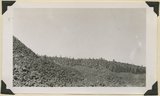
1927
1928
1929
1930
1931
1932
1933
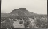
1934
1935
1936
1937
1938
1939
1940
1941
1942
1943
1944
1945
1946
1947
1948
1949
1950
1951
1952
1953
1954
1955
1956
1957
1958
1959
1960
1961
1962
1963
1964
1965
1966
1967
1968
1969
1970
1971
1972
1973
1974
1975
1976
1977
1978
1979
1980
1981
1982
1983
1984
1985
1986
1987
1988
1989
1990
1991
1992
1993
Type
Image
3,451
Format
image/jpeg
3,451
Collection
Photo Archives
3,451
Filters:
Type:
"Image"
Collection Name:
"Herbert E. Gregory"
Format:
"image/jpeg"
176
-
200
of
3,451
<
3
4
5
6
7
8
9
10
11
12
>
Gallery view
Number of results to display per page
10
25
50
100
200
Sort by Relevance
Sort by Title A-Z
Sort by Title Z-A
Sort by Date Ascending
Sort by Date Descending
Sort by Last Modified Ascending
Sort by Last Modified Descending
Title
Date
Type
176
Barohoini Bridge, 1910
1910
Image
177
Barohoini Bridge, looking downstream, i.e. northwest, 1910 (Photo G178A)
1910
Image
178
Barohoini Bridge, looking downstream, i.e. northwest, 1910 (Photo G178A)
1910
Image
179
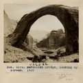
Barohoini Bridge, looking upstream, 1910
1910
Image
180
Barohoini Bridge, looking upstream, 1910 (Photo G179)
1910
Image
181
Barohoini Bridge, looking upstream, 1910 (Photo G179)
1910
Image
182
Barohoini Bridge, northeast arch, 1910 (Photo G180)
1910
Image
183
Barohoini Bridge, northeast arch, 1910 (Photo G180)
1910
Image
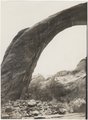
184
Barohoini Bridge, top of arch, 1910 (Photo N-M100)
1910
Image
185
Barohoini Natural Bridge, 10+ mi. northwest of Navajo Mt., Utah in LaPlata strata, 1910. Looking down stream northwest from distance of 1+ mi. (Photo G176)
1910
Image
186
Barrett, Gregory
1900
Image
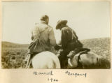
187
Barrett, Gregory, 1900
1900
Image
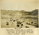
188
Basalt cap on Dolores (Triassic) on Holbrook-Keams Canyon road, 9± mi. south of Biddehoche, Arizona, 1909 (photo G-69)
1909
Image
189
Basalt cone near "corrals," upper Kanab Valley. Pinon and juniper. Kane County, Utah, 1932.
1934
Image
190
Basalt flow from Bald Knob Volcano, upper Johnson Canyon. Kane County, Utah, 1938.
1938
Image
191
Basalt flow from Horsetail Mountain near its termination (eastward; right), Iron County, UT, 1942
1942
Image
192
Basalt in Moenkopi, north wash.
1930; 1931; 1932; 1933; 1934; 1935; 1936; 1937
Image
193
Basalt wall of East Fork of Virgin River above Glendale. Lava that filled the ancient canyon has been trenched. Kane County, Utah.
1930
Image
194
Basalt, Cedar Springs, AZ. 35± mi. north of Winslow. 1911 (Photo G242)
1911
Image
195
Basalt, head of Rock Creek. Old lava (foreground) and end of newer flow (center). Garfield County, UT, 1944
1944
Image
196
Basalt-capped mesa on Dolores (Triassic), 6± miles south of Beddehoche (Indian Wells), Ariz., 1909 (photo G-67)
1909
Image
197
Basalt-capped mesa on Dolores (Triassic), 6± miles south of Beddehoche (Indian Wells), Ariz., 1909 (photo G-67)
1909
Image
198
Basalt-capped mesa on Dolores (Triassic), 8± miles south of Beddehoche, Ariz., 1909 (photo G-68)
1909
Image
199
Basalt-capped mesa on Dolores (Triassic), 8± miles south of Beddehoche, Ariz., 1909 (photo G-68)
1909
Image
200
Basalt-capped mesa with dike on Dolores (Triassic), 8± miles south-southwest of Beddehoche (Indian Wells), Ariz., 1909 (photo G-66)
1909
Image
176
-
200
of
3,451
<
3
4
5
6
7
8
9
10
11
12
>