Home
Browse
Ask Us
Chat
Harmful Language Statement
Log in
Institutional Repository
Advanced Search
Year
1970
1971
1972
1973
1974
1975
1976
1977
1978
1979
1980
1981
1982
1983
1984
1985
1986
1987
1988
1989
1990
1991
1992
1993
1994
1995
1996
1997
1998
1999
2000
2001
2002
2003
2004
2005
2006
2007
2008
2009
2010
2011
2012
2013
2014
2015
2016
TO
1970
1971
1972
1973
1974
1975
1976
1977
1978
1979
1980
1981
1982
1983
1984
1985
1986
1987
1988
1989
1990
1991
1992
1993
1994
1995
1996
1997
1998
1999
2000
2001
2002
2003
2004
2005
2006
2007
2008
2009
2010
2011
2012
2013
2014
2015
2016
Type
Text
35
Image
1
Format
application/pdf
122
image/jpeg
81
application/vnd.ms-excel
5
application/vnd.ms-powerpoint
3
application/msword
1
application/zip
1
More
Collection
Electronic University Archive
211
Institute for Clean and Secure Energy...
1
UScholar Works
1
Filters:
School Or College:
"University of Utah"
76
-
100
of
213
<
1
2
3
4
5
6
7
8
9
>
Gallery view
Number of results to display per page
10
25
50
100
200
Sort by Relevance
Sort by Title A-Z
Sort by Title Z-A
Sort by Date Ascending
Sort by Date Descending
Sort by Last Modified Ascending
Sort by Last Modified Descending
Title
Date
Type
Setname
76
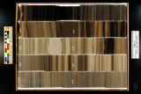
Skyline 16: SW SW sec. 10 11S 25E Uintah County, Utah. Box 53 Depth: 540.0 - 550.0 ft.
2015-07
ir_eua
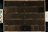
77
Skyline 16: SW SW sec. 10 11S 25E Uintah County, Utah. Box 56 Depth: 570.0 - 580.0 ft.
2015-07
ir_eua
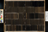
78
Skyline 16: SW SW sec. 10 11S 25E Uintah County, Utah. Box 58 Depth: 590.0 - 600.0 ft.
2015-07
ir_eua
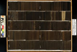
79
Skyline 16: SW SW sec. 10 11S 25E Uintah County, Utah. Box 44 Depth: 450.0 - 460.0 ft.
2015-07
ir_eua
80
Skyline 16: SW SW sec. 10 11S 25E Uintah County, Utah. Box 31 Depth: 320.0 - 330.0 ft.
2015-07
ir_eua
81
Skyline 16: SW SW sec. 10 11S 25E Uintah County, Utah. Box 32 Depth: 330.0 - 340.0 ft.
2015-07
ir_eua
82
Skyline 16: SW SW sec. 10 11S 25E Uintah County, Utah. Box 29 Depth: 300.0 - 310.0 ft.
2015-07
ir_eua
83
Skyline 16: SW SW sec. 10 11S 25E Uintah County, Utah. Box 24 Depth: 250.0 - 260.0 ft.
2015-07
ir_eua
84
Skyline 16: SW SW sec. 10 11S 25E Uintah County, Utah. Box 33 Depth: 340.0 - 350.0 ft.
2015-07
ir_eua
85
Skyline 16: SW SW sec. 10 11S 25E Uintah County, Utah. Box 23 Depth: 240.0 - 250.0 ft.
2015-07
ir_eua
86
Skyline 16: SW SW sec. 10 11S 25E Uintah County, Utah. Box 34 Depth: 350.0 - 360.0 ft.
2015-07
ir_eua
87
Skyline 16: SW SW sec. 10 11S 25E Uintah County, Utah. Box 26 Depth: 270.0 - 280.0 ft.
2015-07
ir_eua
88
Skyline 16: SW SW sec. 10 11S 25E Uintah County, Utah. Box 30 Depth: 310.0 - 320.0 ft.
2015-07
ir_eua
89
Skyline 16: SW SW sec. 10 11S 25E Uintah County, Utah. Box 21 Depth: 220.0 - 230.0 ft.
2015-07
ir_eua
90
Skyline 16: SW SW sec. 10 11S 25E Uintah County, Utah. Box 25 Depth: 260.0 - 270.0 ft.
2015-07
ir_eua
91
Skyline 16: SW SW sec. 10 11S 25E Uintah County, Utah. Box 28 Depth: 290.0 - 300.0 ft.
2015-07
ir_eua
92
Skyline 16: SW SW sec. 10 11S 25E Uintah County, Utah. Box 27 Depth: 280.0 - 290.0 ft.
2015-07
ir_eua
93
Skyline 16: SW SW sec. 10 11S 25E Uintah County, Utah. Box 22 Depth: 230.0 - 240.0 ft.
2015-07
ir_eua
94
Clean and Secure Energy from Domestic Oil Shale and Oil Sands Resources: Quarterly progress report - January 2015 to March 2015
2015
ir_eua
95
Pore scale analysis of oil shale pyrolysis by X-ray CT and LB simulation
2010-09-09
ir_eua
96
Underground coal thermal treatment research at the University of Utah
2011-03-23
ir_eua
97
Accelerating deployment of retrofitable CO2 capture technologies through predictivity: (Simulation, verification, validation / uncertainty quantification) - 2010 Annual report (for year 1 of 3) to DOE NNSA from The University of Utah
2011
ir_eua
98
Integrated sedimentary and geochemical investigation of core form the upper Green River Formation lacustrine deposits, Uinta Basin, Utah
2010-04-12
ir_eua
99
SO3 formation during oxy-coal combustion - Presentation
2010-06-10
ir_eua
100
SO3 formation during oxy-coal combustion
2010-06-10
ir_eua
76
-
100
of
213
<
1
2
3
4
5
6
7
8
9
>