Home
Browse
Ask Us
Chat
Harmful Language Statement
Log in
Advanced Search
Year
1872
1873
1874
1875
1876
1877
1878
1879
1880
1881
1882
1883
1884
1885
1886
1887
1888
1889
1890
1891
1892
1893
1894
1895
1896
1897
1898
1899
1900
1901
1902
1903
1904
1905
1906
1907
1908
1909
1910
1911
1912
1913
1914
1915
1916
1917
1918
1919
1920
1921
1922
1923
1924
1925
1926
1927
1928
1929
1930
1931
1932
1933
1934
1935
1936
1937
1938
1939
1940
1941
1942
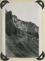
1943
1944
1945
1946
1947
1948
1949
1950
1951
1952
1953
1954
1955
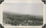
1956
1957
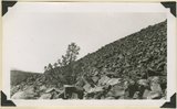
1958
1959
1960
1961
1962
1963
1964
1965
1966
1967
1968
1969
1970
1971
1972
1973
1974
1975
1976
1977
1978
1979
1980
1981
1982
1983
1984
1985
1986
1987
1988
1989
1990
1991
1992
1993
TO
1872
1873
1874
1875
1876
1877
1878
1879
1880
1881
1882
1883
1884
1885
1886
1887
1888
1889
1890
1891
1892
1893
1894
1895
1896
1897
1898
1899
1900
1901
1902
1903
1904
1905
1906
1907
1908
1909
1910
1911
1912
1913
1914
1915
1916
1917
1918
1919
1920
1921
1922
1923
1924
1925
1926
1927
1928
1929
1930
1931
1932
1933
1934
1935
1936
1937
1938
1939
1940
1941
1942
1943
1944
1945
1946
1947
1948
1949
1950
1951
1952
1953
1954
1955
1956
1957
1958
1959
1960
1961
1962
1963
1964
1965
1966
1967
1968
1969
1970
1971
1972
1973
1974
1975
1976
1977
1978
1979
1980
1981
1982
1983
1984
1985
1986
1987
1988
1989
1990
1991
1992
1993
Type
Image
3,521
Image/StillImage
143
Format
image/jpeg
3,594
application/pdf
70
Collection
Photo Archives
3,521
UAIDA Main Collection
143
Filters:
Collection Name:
"Herbert E. Gregory"
76
-
100
of
3,664
<
1
2
3
4
5
6
7
8
9
10
>
Gallery view
Number of results to display per page
10
25
50
100
200
Sort by Relevance
Sort by Title A-Z
Sort by Title Z-A
Sort by Date Ascending
Sort by Date Descending
Sort by Last Modified Ascending
Sort by Last Modified Descending
Title
Date
Type
Setname
76
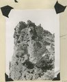
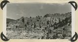
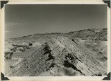
Brian Head formation at the 'Castles,' Castle Creek. Garfield County, UT, 1944
1944
Image
uum_map
77
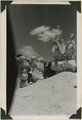
Brian Head formation at the 'Castles,' Castle Creek. Garfield County, UT, 1944. Details of erosion
1944
Image
uum_map
78
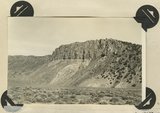
Brian Head formation capped by lava (rhyolite?): Cliff on upthrown side of Paunsaugunt fault. East fork of Sevier River near the mouth of Deer Creek. Garfield County, UT. 1943
1943
Image
uum_map
79
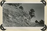
Brian Head formation in the walls of Panguitch Canyon near power house. Garfield County, UT. 1943
1943
Image
uum_map
80
Brian Head formation underlain by pink Wasatch limestone on Highway 89, 2± miles north of Castle Creek. Garfield County, UT, 1944
1944
Image
uum_map
81
Brian Head formation, branch of Asay Creek; lies beneath basalt flows. Garfield County, UT, 1944
1944
Image
uum_map
82
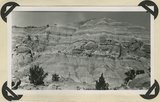
Brian Head formation, consolidated (white wall) and disintegrated (upper slopes), and pink Wasatch limestones (lowest slopes). Seamans Canyon west of Gravel Pass. Kane County, UT, 1944
1944
Image
uum_map
83
Brian Head formation, consolidated (white wall) and disintegrated (upper slopes), and pink Wasatch limestones (lowest slopes). Seamans Canyon west of Gravel Pass. Kane County, UT, 1944
1944
Image
uum_map
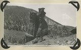
84
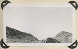
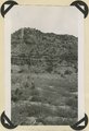
Burro Gap on East Fork of Sevier River above mouth of Deer Creek. Locus of Paunsaugunt fault; upthrow on east right. Garfield County, UT. 1943
1943
Image
uum_map
85
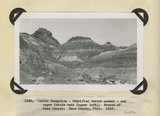
Chile formation, Petrified Forest member, and upper Chinle beds ( upper left). Branch of Road Canyon. Kane County, UT. 1943
1943
Image
uum_map
86
Chinle formation 2 miles northwest abandoned village of Paria. Kane County, UT. 1943
1943
Image
uum_map
87
Chinle formation, Petrified Forest member. Head of Fossil Wood Creek. Kane County, UT. 1943
1943
Image
uum_map
88
Chinle formation, upper red beds capped by remnants of Wingate sandstone. Five Pines Wash. Kane County, UT. 1943
1943
Image
uum_map
89
Chinle formation, upper red beds near mouth of Box Elder Canyon. Kane County, UT. 1943
1943
Image
uum_map
90
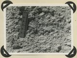
Detailed view of pumice conglomerate in the Brian Head formation, Casto Bluff, Garfield County, UT, 1943
1943
Image
uum_map
91
Detailed view of pumice conglomerate in the Brian Head formation, Casto Bluff, Garfield County, UT, 1943
1943
Image
uum_map
92
End of basalt flow in Black Rock Valley. White rocks (foreground) and left sky line (Haycock Mountain) of Brian Head formation. Garfield County, UT, 1944
1944
Image
uum_map
93
End of basalt flow in Black Rock Valley. White rocks (foreground) and left sky line (Haycock Mountain) of Brian Head formation. Garfield County, UT, 1944
1944
Image
uum_map
94
End of recent basalt flow at the race track, Panguitch Lake. Garfield County, UT, 1943
1943
Image
uum_map
95
Entrada sandstone, regular bedded shaly phase overlain by undifferentiated Curtis and Winsor formations. Antimony Canyon, Garfield County, UT, 1943
1943
Image
uum_map
96
Eroded flank of the East Kaibab monocline at the junction of Paria River and Cottonwood Creek (left center). The sequence is Navajo (left), upper Jurassic (largely eroded), Dakota, Tropic, and Straight Cliffs. Kane County, UT, 1944
1944
Image
uum_map
97
Erosion features in Entrada sandstone. Antimony Canyon, Garfield County, UT, 1943
1943
Image
uum_map
98
Erosion features in Entrada sandstone. Antimony Canyon, Garfield County, UT, 1943
1943
Image
uum_map
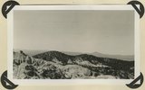
99
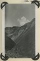
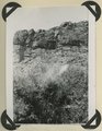
Erosion surface developed on Brian Head formation; downthrow side of Sevier fault. Rim of Sevier Plateau on skyline. Limekiln Gulch, Garfield County, UT, 1942
1942
Image
uum_map
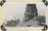
100
Escalante Canyon 2 miles below Big Bend. Walls of Navajo sandstone 800 feet high. Garfield, UT, 1944
1944
Image
uum_map
76
-
100
of
3,664
<
1
2
3
4
5
6
7
8
9
10
>