Home
Browse
Ask Us
Chat
Harmful Language Statement
Log in
Photo Archives
Advanced Search
About
Over 70,000 photos covering a variety of topics from Marriott Library Special Collections
Year
1930
1931
1932
1933
1934
1935
1936
1937
1938
1939
1940
1941
1942
1943
1944
1945
1946
1947
1948
1949
1950
1951
1952
1953
1954
1955
1956
1957
1958
1959
1960
1961
1962
1963
1964
1965
1966
1967
1968
1969
1970
TO
1930
1931
1932
1933
1934
1935
1936
1937
1938
1939
1940
1941
1942
1943
1944
1945
1946
1947
1948
1949
1950
1951
1952
1953
1954
1955
1956
1957
1958
1959
1960
1961
1962
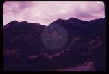
1963
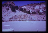
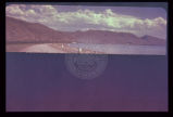
1964
1965
1966
1967
1968
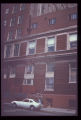
1969
1970
Type
Image
100
Format
image/jpeg
100
Collection Name
Environmental Geology in Utah
100
Filters:
Collection Name:
"Environmental Geology in Utah"
Type:
"Image"
Collection:
"uum_map"
76
-
100
of
100
<
1
2
3
4
>
Gallery view
Number of results to display per page
10
25
50
100
200
Sort by Relevance
Sort by Title A-Z
Sort by Title Z-A
Sort by Date Ascending
Sort by Date Descending
Sort by Last Modified Ascending
Sort by Last Modified Descending
Sort by Photo Number
Title
Collection Number And Name
Photo Number
76
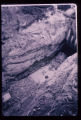
This water storage reservoir has failed; it was placed improperly upon a stratum of gypsum (white layers in photo) which partially dissolved.
P1274 Environmental Geology and Geologic Hazards in Utah Photograph Collection
p1274n076
77
Crack in soil alongside reservoir, showing subsidence. Reservoir was the only water storage facility serving several thousand people.
P1274 Environmental Geology and Geologic Hazards in Utah Photograph Collection
p1274n077
78
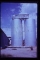
These twin tanks deverge from bottom to top. Differential settling of their foundations caused this.
P1274 Environmental Geology and Geologic Hazards in Utah Photograph Collection
p1274n078
79
Damage to a house in Salt Lake City results from an unsatisfactory foundation. Note in particular the dropping of the arch over the doorway.
P1274 Environmental Geology and Geologic Hazards in Utah Photograph Collection
p1274n079
80
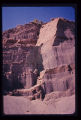
Arrow points to incipient failure of an excavation wall for a foundation for a multistory office building. Material is horizontally stratified Lake Bonneville silts and sands.
P1274 Environmental Geology and Geologic Hazards in Utah Photograph Collection
p1274n080
81
Excavation and trench cave-ins occur all too frequently along Utah's Wasatch Front. Each year sees its fatalities from this cause.
P1274 Environmental Geology and Geologic Hazards in Utah Photograph Collection
p1274n081
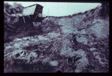
82
The circumstances here probably make a utility trench cave-in inevitable. A perched water table is sapping fine sand from underneath a thick silt bed, leaving the latter unsupported. Failure will be too rapid for escape of a workman who may be in the trench at the wrong moment.
P1274 Environmental Geology and Geologic Hazards in Utah Photograph Collection
p1274n082
83
Damage to a major edifice in Salt Lake City resulted from differential settling of the two portions of the building. Arrow points to zone of distress which extends to foundation level. Note that window frames are askew.
P1274 Environmental Geology and Geologic Hazards in Utah Photograph Collection
p1274n083
84
Ground subsidence leaves this fireplug supported above the sidewalk in downtown Salt Lake City.
P1274 Environmental Geology and Geologic Hazards in Utah Photograph Collection
p1274n084
85
Map of Utah showing the 5 major active fault zones in the state.
P1274 Environmental Geology and Geologic Hazards in Utah Photograph Collection
p1274n085
86
Photograph of a relief map using oblique illumination to highlight the topography. Note the steep slope along the east shore of Bear Lake. This slope marks the active Bear Lake Fault bounding the lake on the east. The lake sits in a graben, a downdropping block of earth.
P1274 Environmental Geology and Geologic Hazards in Utah Photograph Collection
p1274n086
87
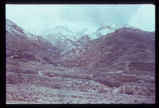
View across the north end of Bear Lake looking east at the truncated spurs, geomorphologic evidence of the Bear Lake Fault.
P1274 Environmental Geology and Geologic Hazards in Utah Photograph Collection
p1274n087
88
Fault trace of the active Wasatch Fault across a glacial moraine at the mouth of Little Cottonwood Canyon in Salt Lake County. Note that the fault scarplet is virtually unvegetated, indicative of its recency.
P1274 Environmental Geology and Geologic Hazards in Utah Photograph Collection
p1274n088
89
Hebgen Fault scarp near Cabin Creek, aftermath of the 1959 Montana earthquake. Note tilt of trees and the recovery of vegetation over the scarp in only 11 years (photo taken August 1970).
P1274 Environmental Geology and Geologic Hazards in Utah Photograph Collection
p1274n089
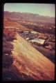
90
Exposure of a branch of the Wasatch Fault in a sand and gravel pit along the mountain front. Amount of displacement is indeterminable from the stratigraphy exposed. Note that the fault is planar and stands out with relative resistance to the elements despite lack of cementation of the sand and gravel.
P1274 Environmental Geology and Geologic Hazards in Utah Photograph Collection
p1274n090
91
Portion of the East Bench along the mountain front in Salt Lake County. It has been dissected by strands of the Wasatch Fault. Since this photo was taken a housing development has been built on this terrain.
P1274 Environmental Geology and Geologic Hazards in Utah Photograph Collection
p1274n091
92
Multistory apartment house sitting astride the East Bench Fault of the Wasatch Fault Zone in Salt Lake City.
P1274 Environmental Geology and Geologic Hazards in Utah Photograph Collection
p1274n092
93
Fault trace revealed in the foundation excavation for the building depicted in the preceding photograph (p1274n092).
P1274 Environmental Geology and Geologic Hazards in Utah Photograph Collection
p1274n093
94
Closeup view of the fault shown in last slide (p1274n093).
P1274 Environmental Geology and Geologic Hazards in Utah Photograph Collection
p1274n094
95
Map of portion of the Wasatch Front showing the Wasatch Fault Zone in relation to the Salt Lake City aqueduct system (with water system facilities as projected into the 20th Century). Map illustrates severity of the earthquake problem in urban Utah.
P1274 Environmental Geology and Geologic Hazards in Utah Photograph Collection
p1274n095
96
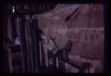
Branch of the Wasatch Fault exposed in utility trench excavation in Salt Lake City. Hammer and field book are at the same stratigraphic horizon, indicating a displacement of 2 1/2 feet in late mudflow deposits, just below the ground surface.
P1274 Environmental Geology and Geologic Hazards in Utah Photograph Collection
p1274n096
97
Geologic map of Bear Lake showing the geologic hazards in the area. The active Bear Lake fault zone is outlined in yellow, and landslides in red. Hazardous areas must be given due consideration by planning authorities.
P1274 Environmental Geology and Geologic Hazards in Utah Photograph Collection
p1274n097
98
Map of Bear Lake showing bottom contours of the lake and depth to bedrock beneath soft valley sediments. The delta-fan areas along the east shore are colored yellow to indicate another hazard. Response of the delta-fan soft sediments to earthquake vibrations is anticipated to be poor, almost certainly causing severe damage to structures built on these level areas. Different earth materials may be expected to behave differently when shaken in an earthquake. The closeness of the contours bounding the delta-fans indicates a steep front for each. Movement of material in an earthquake may be expected to occur towards these steep fronts.
P1274 Environmental Geology and Geologic Hazards in Utah Photograph Collection
p1274n098
99
Landslide along a scarp of the East Bench Fault in Salt Lake City. No earth tremor is known to have triggered this slide, but an earthquake could trigger similar slides, given similar geologic conditions.
P1274 Environmental Geology and Geologic Hazards in Utah Photograph Collection
p1274n099
100
Steep, high, artificial fill slopes in or near the Wasatch Fault Zone. Downslope from these fills lie dense residential developments. Atop these fills are residences. How may these earth materials be expected to react to seismic vibrations?
P1274 Environmental Geology and Geologic Hazards in Utah Photograph Collection
p1274n100
76
-
100
of
100
<
1
2
3
4
>