Home
Browse
Ask Us
Chat
Harmful Language Statement
Log in
Advanced Search
Year
1849
1850
1851
1852
1853
1854
1855
1856
1857
1858
1859
1860
1861
1862
1863
1864
1865
1866
1867
1868
1869
1870
1871
1872
1873
1874
1875
1876
1877
1878
1879
1880
1881
1882
1883
1884
1885
1886
1887
1888
1889
1890
1891
1892
1893
1894
1895
1896
1897
1898
1899
1900
1901
1902
1903
1904
1905
1906
1907
1908
1909
1910
1911
1912
1913
1914
1915
1916
1917
1918
1919
1920
1921
1922
1923
1924
1925
1926
1927
1928
1929
1930
1931
1932
1933
1934
1935
1936
1937
1938
1939
1940
1941
1942
1943
1944
1945
1946
1947
1948
1949
1950
1951
1952
1953
1954
1955
1956
1957
1958
1959
1960
1961
1962
1963
1964
1965
1966
1967
1968
1969
1970
1971
1972
1973
1974
1975
1976
1977
1978
1979
1980
1981
1982
1983
1984
1985
1986
1987
1988
1989
1990
1991
1992
1993
1994
1995
1996
1997
1998
1999
2000
2001
2002
2003
2004
2005
2006
2007
2008
2009
2010
TO
1849
1850
1851
1852
1853
1854
1855
1856
1857
1858
1859
1860
1861
1862
1863
1864
1865
1866
1867
1868
1869
1870
1871
1872
1873
1874
1875
1876
1877
1878
1879
1880
1881
1882
1883
1884
1885
1886
1887
1888
1889
1890
1891
1892
1893
1894
1895
1896
1897
1898
1899
1900
1901
1902
1903
1904
1905
1906
1907
1908
1909
1910
1911
1912
1913
1914
1915
1916
1917
1918
1919
1920
1921
1922
1923
1924
1925
1926
1927
1928
1929
1930
1931
1932
1933
1934
1935
1936
1937
1938
1939
1940
1941
1942
1943
1944
1945
1946
1947
1948
1949
1950
1951
1952
1953
1954
1955
1956
1957
1958
1959
1960
1961
1962
1963
1964
1965
1966
1967
1968
1969
1970
1971
1972
1973
1974
1975
1976
1977
1978
1979
1980
1981
1982
1983
1984
1985
1986
1987
1988
1989
1990
1991
1992
1993
1994
1995
1996
1997
1998
1999
2000
2001
2002
2003
2004
2005
2006
2007
2008
2009
2010
Type
Image/StillImage
133
Text
60
Image/MovingImage
7
Sound
2
Format
image/jpeg
104
application/pdf
52
application/zip
3
video/mp4
1
Collection
Multimedia Archives Photographs - Res...
44
UAIDA Main Collection
159
51
-
75
of
203
<
1
2
3
4
5
6
7
8
9
>
Gallery view
Number of results to display per page
10
25
50
100
200
Sort by Relevance
Sort by Title A-Z
Sort by Title Z-A
Sort by Date Ascending
Sort by Date Descending
Sort by Last Modified Ascending
Sort by Last Modified Descending
Title
Date
Type
Setname
51
Factors Affecting Reading Outcomes Across Time in Bureau of Indian Education Reading First Schools
2010
Text
uaida_main
52
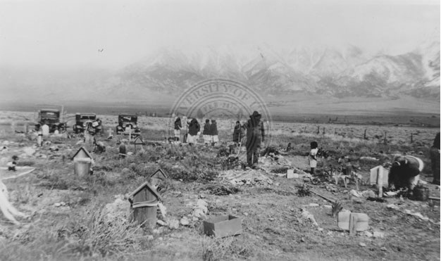
Family gathered at cemetery.
Image/StillImage
uaida_main
53
Figure 01: Skull Valley, view from the northwest at, or near Timpie Junction. Jedediah Smith in 1827 climed {sic} the knob in the distance and obtained a glimpse of the Great Salt Lake
1939
Image/StillImage
uum_mapr
54
Figure 02: Knolls, Utah. View southwest. This locality is on the eastern edge of the Great Salt Lake Desert
1939
Image/StillImage
uum_mapr
55
Figure 03: The Bonneville Salt Flats on the Great Salt Lake Desert, Utah. Captain Cobb's world speed record car in the distance
1939
Image/StillImage
uum_mapr
56
Figure 04: Sage Brush in a favorable living locality just south of Skull Valley. This brush is as much as fourteen feet high, indicating a rich soil and a considerable amount of moisture
1939
Image/StillImage
uum_mapr
57
Figure 05: Deep Creek Valley from the Deep Creek Mountains. The Tippets Mountains appear twenty miles westward. The Gosiute village is the center of the picture
1939
Image/StillImage
uum_mapr
58
Figure 06: The Deep Creek Mountains
1939
Image/StillImage
uum_mapr
59
Figure 08a: Some modern means of subsistence: weaving a cradle board for sale
1939
Image/StillImage
uum_mapr
60
Figure 08b: Some modern means of subsistence: Weaving a basket preparatory to the pine nut gathering season
1939
Image/StillImage
uum_mapr
61
Figure 12: Outcropping in the Simpson Mountains on which petroglyphs may be found
1939
Image/StillImage
uum_mapr
62
Figure 13: Petroglyph in the Simpson Mountains
1939
Image/StillImage
uum_mapr
63
Figure 14: Recess in Tunnel Canyon, Nevada, in which Pictographs occur
1939
Image/StillImage
uum_mapr
64
Figure 15: Pictographs in Tunnel Canyon
1939
Image/StillImage
uum_mapr
65
Figure 16: Archaeological sites along the east bank of Fifteen-Mile Creek near the Goshute {sic} Reservation Agency Headquarters
1939
Image/StillImage
uum_mapr
66
Figure 17: Locality of archaeological sites on the west bank of Fifteen-Mile Creek opposite the Gosiute Village. View north
1939
Image/StillImage
uum_mapr
67
Figure 18: The western limit of the Gosiute, the east slope of the Steptoe Mountains in Nevada. View south toward Spring Valley
1939
Image/StillImage
uum_mapr
68
Figure 20: Photograph of the type of fence used by the Gosiute in the building of an antelope corral
1939
Image/StillImage
uum_mapr
69
Figure 21: Meat drying on a line hung between two shade trees. Photograph from Deep Creek
1939
Image/StillImage
uum_mapr
70
Figure 22: Some modern means of subsistence: c. growing alfalfa and other products for Gosiute consumption
1939
Image/StillImage
uum_mapr
71
Figure 23: Framework of a Deep Creek "Little House" with a piece of Canvas Still Attached After it was Abandoned. The Tent in the Background was used as the Family Dwelling
1939
Image/StillImage
uum_mapr
72
Figure 24: Distant view of a Gosiute house showing a conical "Little House" to the right. A cellar is located on the opposite side
1939
Image/StillImage
uum_mapr
73
Figure 25: Exterior view of a Gosiute House
1939
Image/StillImage
uum_mapr
74
Figure 26: Interior view of a Gosiute house showing roof construction
1939
Image/StillImage
uum_mapr
75
Figure 27: View of the finest house constructed at Deep Creek by an Indian. It was abandoned at the death of several of the members of the family. The door on this house faced south, even though its inhabitants were peyote members
1939
Image/StillImage
uum_mapr
51
-
75
of
203
<
1
2
3
4
5
6
7
8
9
>