Home
Browse
Ask Us
Chat
Harmful Language Statement
Log in
Advanced Search
Year
1839
1840
1841
1842
1843
1844
1845
1846
1847
1848
1849
1850
1851
1852
1853
1854
1855
1856
1857
1858
1859
1860
1861
1862
1863
1864
1865
1866
1867
1868
1869
1870
1871
1872
1873
1874
1875
1876
1877
1878
1879
1880
1881
1882
1883
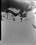
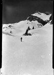
1884
1885
1886
1887
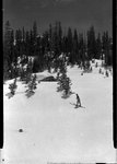
1888
1889
1890
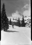
1891
1892
1893
1894
1895
1896
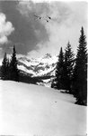
1897
1898
1899
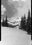
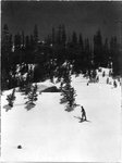
1900
1901
1902
1903
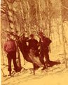
1904
1905
1906
1907
1908
1909
1910
1911
1912
1913
1914
1915
1916
1917
1918
1919
1920
1921
1922
1923
1924
1925
1926
1927
1928
1929
1930
1931
1932
1933
1934
1935
1936
1937
1938
1939
1940
1941
1942
1943
1944
1945
1946
1947
1948
1949
1950
1951
1952
1953
1954
1955
1956
1957
1958
1959
1960
1961
1962
1963
1964
1965
1966
1967
1968
1969
1970
1971
1972
1973
1974
1975
1976
1977
1978
1979
1980
1981
1982
1983
1984
1985
1986
1987
1988
1989
1990
1991
1992
1993
1994
1995
1996
1997
1998
1999
2000
2001
2002
2003
2004
2005
2006
2007
2008
2009
2010
2011
2012
2013
2014
2015
2016
2017
2018
2019
2020
2021
2022
2023
2024
TO
1839
1840
1841
1842
1843
1844
1845
1846
1847
1848
1849
1850
1851
1852
1853
1854
1855
1856
1857
1858
1859
1860
1861
1862
1863
1864
1865
1866
1867
1868
1869
1870
1871
1872
1873
1874
1875
1876
1877
1878
1879
1880
1881
1882
1883
1884
1885
1886
1887
1888
1889
1890
1891
1892
1893
1894
1895
1896
1897
1898
1899
1900
1901
1902
1903
1904
1905
1906
1907
1908
1909
1910
1911
1912
1913
1914
1915
1916
1917
1918
1919
1920
1921
1922
1923
1924
1925
1926
1927
1928
1929
1930
1931
1932
1933
1934
1935
1936
1937
1938
1939
1940
1941
1942
1943
1944
1945
1946
1947
1948
1949
1950
1951
1952
1953
1954
1955
1956
1957
1958
1959
1960
1961
1962
1963
1964
1965
1966
1967
1968
1969
1970
1971
1972
1973
1974
1975
1976
1977
1978
1979
1980
1981
1982
1983
1984
1985
1986
1987
1988
1989
1990
1991
1992
1993
1994
1995
1996
1997
1998
1999
2000
2001
2002
2003
2004
2005
2006
2007
2008
2009
2010
2011
2012
2013
2014
2015
2016
2017
2018
2019
2020
2021
2022
2023
2024
Type
Image
50
Image/StillImage
46
Image/MovingImage
7
Text
2
Sound
1
Format
image/jpeg
134
video/mp4
6
application/pdf
3
Collection
Anthropology Ethnographic Collections
3
George M. Ottinger Photograph Collection
3
Home Movie Collection
5
Olympic Legacy
5
Photo Archives
45
Rare Books Collection
4
Regional History Center
12
Richard Kern's Far West Sketches: A V...
3
Salt Lake Tribune Negative Collection
12
Ski and Snow Sports Photo Archives
30
Thorne Photographs
4
UAIDA Main Collection
1
Utah Artists Project
1
Utah Historical Society Oral History ...
2
Utah Humanities Rural Utah Crossroads...
1
Utah River Running Photo Archives
1
Vernal Express Photographs
11
More
51
-
75
of
143
<
1
2
3
4
5
6
>
Gallery view
Number of results to display per page
10
25
50
100
200
Sort by Relevance
Sort by Title A-Z
Sort by Title Z-A
Sort by Date Ascending
Sort by Date Descending
Sort by Last Modified Ascending
Sort by Last Modified Descending
Title
Date
Type
Setname
51
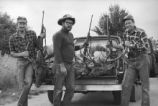
Elk Hunters Score Elk
1967-10-05
Image
ucl_vep
52
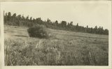
Gooseberry Ranger station, Elk Ridge. San Juan County, UT, 1928
1928
Image
uum_map
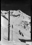
53
Just below Taggert Hut looking North East into Montezuma Basin, circa April 30, 1948
1948-04-28
uum_map_usa
54
Just below Taggert Hut looking North East into Montezuma Basin, circa April 30, 1948 (Negative)
1948-04-28
uum_map_usa
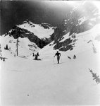
55
Just below Taggert Hut looking south West, hut just up and to the left, circa April 30, 1948
1948-04-28
uum_map_usa
56
Just below Taggert Hut looking south West, hut just up and to the left, circa April 30, 1948 (Negative)
1948-04-28
uum_map_usa
57
Looking South East at the tow in Pearl Basin, circa May 1, 1948
1948-05-01
uum_map_usa
58
Looking South West from Taggert Hut, circa April 30, 1948
1948-04-28
uum_map_usa
59
Looking South West from Taggert Hut, circa April 30, 1948 (Negative)
1948-04-28
uum_map_usa
60
Looking West below Taggert Hut, circa May 1, 1948
1948-05-01
uum_map_usa
61
Looking West below Taggert Hut, circa May 1, 1948
1948-05-01
uum_map_usa
62
Looking West below Taggert Hut, circa May 1, 1948 (Negative)
1948-05-01
uum_map_usa
63
Looking West below Taggert Hut, circa May 1, 1948 (Negative)
1948-05-01
uum_map_usa
64
Looking West just below Taggert Hut (up and to the left), circa April 30, 1948
1948-04-28
uum_map_usa
65
Looking West just below Taggert Hut (up and to the left), circa April 30, 1948 (Negative)
1948-04-28
uum_map_usa
66
South West Taggert Hut, looking North West to Castle Peak, circa April 30, 1948
1948-04-28
uum_map_usa
67
South West Taggert Hut, looking North West to Castle Peak, circa April 30, 1948 (Negative)
1948-04-28
uum_map_usa
68
Spicer's Elk Ranch
Image/StillImage
ucl_rhc
69
Taggert Hut looking south, circa April 30, 1948
1948-04-28
uum_map_usa
70
Taggert Hut looking south, circa April 30, 1948 (Negative)
1948-04-28
uum_map_usa
71
Uintah Historical Society Group Visit Elk Horn Loop
1983
Image/StillImage
ucl_rhc
72
Uintah Historical Society Group Visit Elk Horn Loop
1983
Image/StillImage
ucl_rhc
73
Elk Hunting
1949
Image/StillImage
ucl_rhc
74
Same as 838 [View looking west from south end of Elk Ridge across Armstrong Canyon. Moenkopi beds in right foreground, Coconino in middle distance, mesas of Navajo beyond. San Juan County, Utah, 1929.]
1929
Image
uum_map
75
Top of Elk Ridge. View looking northeast from Bears Ears, San Juan County, Utah, 1929.
1929
Image
uum_map
51
-
75
of
143
<
1
2
3
4
5
6
>