Home
Browse
Ask Us
Chat
Harmful Language Statement
Log in
Photo Archives
Advanced Search
About
Over 70,000 photos covering a variety of topics from Marriott Library Special Collections
Year
1930
1931
1932
1933
1934
1935
1936
1937
1938
1939
1940
1941
1942
1943
1944
1945
1946
1947
1948
1949
1950
1951
1952
1953
1954
1955
1956
1957
1958
1959
1960
1961
1962
1963
1964
1965
1966
1967
1968
1969
1970
TO
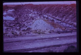
1930
1931
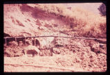
1932
1933
1934
1935
1936
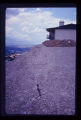
1937
1938
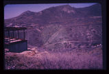
1939
1940
1941
1942
1943
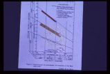
1944
1945
1946
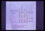
1947
1948
1949
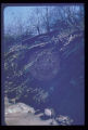
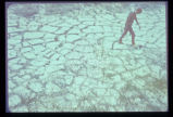
1950
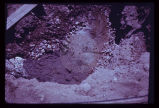
1951
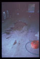
1952
1953
1954
1955
1956
1957
1958
1959
1960
1961
1962
1963
1964
1965
1966
1967
1968
1969
1970
Type
Image
100
Format
image/jpeg
100
Collection Name
Environmental Geology in Utah
100
Filters:
Collection Name:
"Environmental Geology in Utah"
Collection:
"uum_map"
51
-
75
of
100
<
1
2
3
4
>
Gallery view
Number of results to display per page
10
25
50
100
200
Sort by Relevance
Sort by Title A-Z
Sort by Title Z-A
Sort by Date Ascending
Sort by Date Descending
Sort by Last Modified Ascending
Sort by Last Modified Descending
Sort by Photo Number
Title
Collection Number And Name
Photo Number
51
Characteristic arcuate crack pattern in basement of house. Both vertical and lateral displacement is apparent.
P1274 Environmental Geology and Geologic Hazards in Utah Photograph Collection
p1274n051
52
In the same house; the ceiling is clearly distressed.
P1274 Environmental Geology and Geologic Hazards in Utah Photograph Collection
p1274n052
53
Landslide scarp behind house along mountain front in Weber County.
P1274 Environmental Geology and Geologic Hazards in Utah Photograph Collection
p1274n053
54
Ogden Standard Examiner newspaper photograph of mudslide encroaching into dining room.
P1274 Environmental Geology and Geologic Hazards in Utah Photograph Collection
p1274n054
55
Weber Basin Job Corpsmen digging out mudslide debris from hillside house.
P1274 Environmental Geology and Geologic Hazards in Utah Photograph Collection
p1274n055
56
Foothill terrain at base of Wasatch Mountains experienced failure illustrated above.
P1274 Environmental Geology and Geologic Hazards in Utah Photograph Collection
p1274n056
57
Low sun angle illumination, vertical aerial photograph of large ancient landslide in urban environment at mouth of Ogden Canyon.
P1274 Environmental Geology and Geologic Hazards in Utah Photograph Collection
p1274n057
58
Party of people viewing large landslide mass. Slide plane (surface along which mass of earth moved) is evident in photo half way down the exposed wall, sloping towards the party.
P1274 Environmental Geology and Geologic Hazards in Utah Photograph Collection
p1274n058
59
Closeup of slide plane. Note deposition of white calcium carbonate by groundwater along slide plane. Arrow points to smooth, slickensided (grooved) surface on underside of sliding mass.
P1274 Environmental Geology and Geologic Hazards in Utah Photograph Collection
p1274n059
60
Slide of fill material in high, steep fill slope on Salt Lake City's North Bench.
P1274 Environmental Geology and Geologic Hazards in Utah Photograph Collection
p1274n060
61
Closer view of slide cracks in high fill in Salt Lake City subdivision. Note housing density downslope.
P1274 Environmental Geology and Geologic Hazards in Utah Photograph Collection
p1274n061
62
View across City Creek Canyon in Salt Lake City, showing amphitheater-like appearance of ancient landslide. Houses are short distance to left of landslide.
P1274 Environmental Geology and Geologic Hazards in Utah Photograph Collection
p1274n062
63
Hillside subdivision in landslide terrain. Terrain in background has slid in the past. Instrument for measuring ground displacement is housed in box in foreground. White rain gage sits atop instrument housing.
P1274 Environmental Geology and Geologic Hazards in Utah Photograph Collection
p1274n063
64
Undisturbed hillside failing because of lateral and vertical erosion by creek. Debris is continuously removed from toe of sliding hillside by the creek.
P1274 Environmental Geology and Geologic Hazards in Utah Photograph Collection
p1274n064
65
Groundwater, boiling up sand, at depth of a few feet in Sugarhouse, Salt Lake City, revealed by foundation excavation. Water probably arises along East Bench branch of the Wasatch Fault.
P1274 Environmental Geology and Geologic Hazards in Utah Photograph Collection
p1274n065
66
Well points (small diameter water wells) used to dewater a hillside in loose sand to stabilize it after cut was made for roadway.
P1274 Environmental Geology and Geologic Hazards in Utah Photograph Collection
p1274n066
67
Hydrograph depicting flow for the year 1945 of Utah's second largest spring, Swan Creek Spring, west of Bear Lake in northern Utah. Note the fluctuation in flow from April to September. Note also rapid response to spring snowmelt (April and May) and rainfall (June and July). The rock from which the spring issues (aquifer) is limestone. The graph illustrates the importance of controlling development on limestone terrain.
P1274 Environmental Geology and Geologic Hazards in Utah Photograph Collection
p1274n067
68
Bear Lake area map showing: (1) point of issue of Swan Creek Spring, (2) possible contributory sink holes (in red) in the Bear River Range, (3) precipitation (rain and snow) measuring stations (in bluelined blocks).
P1274 Environmental Geology and Geologic Hazards in Utah Photograph Collection
p1274n068
69
Areas of carbonate rock (limestone) outcrops (in blue) in the vicinity of Bear Lake, Utah. Rocks range in age from Cambrian to Jurassic. Development on the outcrop area should be closely monitored to protect the underlying potable water aquifer.
P1274 Environmental Geology and Geologic Hazards in Utah Photograph Collection
p1274n069
70
Table listing types of geologic terrain in the Bear Lake area and their limiting factors for fluid waste disposal by individual home systems. Yellow indicates caution is required and red indicates a critical situation.
P1274 Environmental Geology and Geologic Hazards in Utah Photograph Collection
p1274n070
71
Standard Salinity Hazard chart for groundwater from all aquifers in the Bear Lake area. This chart is used for agricultural purposes. Note that all waters sampled are satisfactory for all plant types.
P1274 Environmental Geology and Geologic Hazards in Utah Photograph Collection
p1274n071
72
Surficial or shallow ground water is subject to pollution from buried solid wastes. Leaching of the wastes can occur in time. This excavation is for a land fill operation where ground water was encountered at a depth of less than 6 feet.
P1274 Environmental Geology and Geologic Hazards in Utah Photograph Collection
p1274n072
73
This pattern of cracking in the unconsolidated clays and silts from ancient Lake Bonneville is the result of shrinking upon drying. Geologic material may be considered as dynamic, not static, and may deform readily under stress. Deformation may damage or destroy structures placed upon this type of geologic material.
P1274 Environmental Geology and Geologic Hazards in Utah Photograph Collection
p1274n073
74
Another example of dynamic forces at work in the geologic environment: pressure ridges formed in the salt crust of Utah's Bonneville Salt Flats. These ridges grow and shrink seasonally.
P1274 Environmental Geology and Geologic Hazards in Utah Photograph Collection
p1274n074
75
Swelling of clay soil as it takes on additional moisture heaved up this garage floor and cracked it.
P1274 Environmental Geology and Geologic Hazards in Utah Photograph Collection
p1274n075
51
-
75
of
100
<
1
2
3
4
>