Home
Browse
Ask Us
Chat
Harmful Language Statement
Log in
Photo Archives
Advanced Search
About
Over 70,000 photos covering a variety of topics from Marriott Library Special Collections
Year
1538
1539
1540
1541
1542
1543
1544
1545
1546
1547
1548
1549
1550
1551
1552
1553
1554
1555
1556
1557
1558
1559
1560
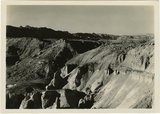
1561
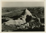
1562
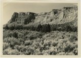
1563
1564
1565
1566
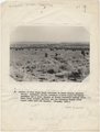
1567
1568
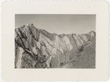
1569
1570
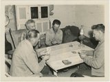
1571
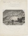
1572
1573
1574
1575
1576
1577
1578
1579
1580
1581
1582
1583
1584
1585
1586
1587
1588
1589
1590
1591
1592
1593
1594
1595
1596
1597
1598
1599
1600
1601
1602
1603
1604
1605
1606
1607
1608
1609
1610
1611
1612
1613
1614
1615
1616
1617
1618
1619
1620
1621
1622
1623
1624
1625
1626
1627
1628
1629
1630
1631
1632
1633
1634
1635
1636
1637
1638
1639
1640
1641
1642
1643
1644
1645
1646
1647
1648
1649
1650
1651
1652
1653
1654
1655
1656
1657
1658
1659
1660
1661
1662
1663
1664
1665
1666
1667
1668
1669
1670
1671
1672
1673
1674
1675
1676
1677
1678
1679
1680
1681
1682
1683
1684
1685
1686
1687
1688
1689
1690
1691
1692
1693
1694
1695
1696
1697
1698
1699
1700
1701
1702
1703
1704
1705
1706
1707
1708
1709
1710
1711
1712
1713
1714
1715
1716
1717
1718
1719
1720
1721
1722
1723
1724
1725
1726
1727
1728
1729
1730
1731
1732
1733
1734
1735
1736
1737
1738
1739
1740
1741
1742
1743
1744
1745
1746
1747
1748
1749
1750
1751
1752
1753
1754
1755
1756
1757
1758
1759
1760
1761
1762
1763
1764
1765
1766
1767
1768
1769
1770
1771
1772
1773
1774
1775
1776
1777
1778
1779
1780
1781
1782
1783
1784
1785
1786
1787
1788
1789
1790
1791
1792
1793
1794
1795
1796
1797
1798
1799
1800
1801
1802
1803
1804
1805
1806
1807
1808
1809
1810
1811
1812
1813
1814
1815
1816
1817
1818
1819
1820
1821
1822
1823
1824
1825
1826
1827
1828
1829
1830
1831
1832
1833
1834
1835
1836
1837
1838
1839
1840
1841
1842
1843
1844
1845
1846
1847
1848
1849
1850
1851
1852
1853
1854
1855
1856
1857
1858
1859
1860
1861
1862
1863
1864
1865
1866
1867
1868
1869
1870
1871
1872
1873
1874
1875
1876
1877
1878
1879
1880
1881
1882
1883
1884
1885
1886
1887
1888
1889
1890
1891
1892
1893
1894
1895
1896
1897
1898
1899
1900
1901
1902
1903
1904
1905
1906
1907
1908
1909
1910
1911
1912
1913
1914
1915
1916
1917
1918
1919
1920
1921
1922
1923
1924
1925
1926
1927
1928
1929
1930
1931
1932
1933
1934
1935
1936
1937
1938
1939
1940
1941
1942
1943
1944
1945
1946
1947
1948
1949
1950
1951
1952
1953
1954
1955
1956
1957
1958
1959
1960
1961
1962
1963
1964
1965
1966
1967
1968
1969
1970
1971
1972
1973
1974
1975
1976
1977
1978
1979
1980
1981
1982
1983
1984
1985
1986
1987
1988
1989
1990
1991
1992
1993
1994
1995
1996
1997
1998
1999
2000
2001
2002
TO
1538
1539
1540
1541
1542
1543
1544
1545
1546
1547
1548
1549
1550
1551
1552
1553
1554
1555
1556
1557
1558
1559
1560
1561
1562
1563
1564
1565
1566
1567
1568
1569
1570
1571
1572
1573
1574
1575
1576
1577
1578
1579
1580
1581
1582
1583
1584
1585
1586
1587
1588
1589
1590
1591
1592
1593
1594
1595
1596
1597
1598
1599
1600
1601
1602
1603
1604
1605
1606
1607
1608
1609
1610
1611
1612
1613
1614
1615
1616
1617
1618
1619
1620
1621
1622
1623
1624
1625
1626
1627
1628
1629
1630
1631
1632
1633
1634
1635
1636
1637
1638
1639
1640
1641
1642
1643
1644
1645
1646
1647
1648
1649
1650
1651
1652
1653
1654
1655
1656
1657
1658
1659
1660
1661
1662
1663
1664
1665
1666
1667
1668
1669
1670
1671
1672
1673
1674
1675
1676
1677
1678
1679
1680
1681
1682
1683
1684
1685
1686
1687
1688
1689
1690
1691
1692
1693
1694
1695
1696
1697
1698
1699
1700
1701
1702
1703
1704
1705
1706
1707
1708
1709
1710
1711
1712
1713
1714
1715
1716
1717
1718
1719
1720
1721
1722
1723
1724
1725
1726
1727
1728
1729
1730
1731
1732
1733
1734
1735
1736
1737
1738
1739
1740
1741
1742
1743
1744
1745
1746
1747
1748
1749
1750
1751
1752
1753
1754
1755
1756
1757
1758
1759
1760
1761
1762
1763
1764
1765
1766
1767
1768
1769
1770
1771
1772
1773
1774
1775
1776
1777
1778
1779
1780
1781
1782
1783
1784
1785
1786
1787
1788
1789
1790
1791
1792
1793
1794
1795
1796
1797
1798
1799
1800
1801
1802
1803
1804
1805
1806
1807
1808
1809
1810
1811
1812
1813
1814
1815
1816
1817
1818
1819
1820
1821
1822
1823
1824
1825
1826
1827
1828
1829
1830
1831
1832
1833
1834
1835
1836
1837
1838
1839
1840
1841
1842
1843
1844
1845
1846
1847
1848
1849
1850
1851
1852
1853
1854
1855
1856
1857
1858
1859
1860
1861
1862
1863
1864
1865
1866
1867
1868
1869
1870
1871
1872
1873
1874
1875
1876
1877
1878
1879
1880
1881
1882
1883
1884
1885
1886
1887
1888
1889
1890
1891
1892
1893
1894
1895
1896
1897
1898
1899
1900
1901
1902
1903
1904
1905
1906
1907
1908
1909
1910
1911
1912
1913
1914
1915
1916
1917
1918
1919
1920
1921
1922
1923
1924
1925
1926
1927
1928
1929
1930
1931
1932
1933
1934
1935
1936
1937
1938
1939
1940
1941
1942
1943
1944
1945
1946
1947
1948
1949
1950
1951
1952
1953
1954
1955
1956
1957
1958
1959
1960
1961
1962
1963
1964
1965
1966
1967
1968
1969
1970
1971
1972
1973
1974
1975
1976
1977
1978
1979
1980
1981
1982
1983
1984
1985
1986
1987
1988
1989
1990
1991
1992
1993
1994
1995
1996
1997
1998
1999
2000
2001
2002
Type
Image
3,426
Text
3
Format
application/pdf
3,426
Collection Name
Olive Woolley Burt
2,015
Rocky Mountain Power Company
343
Leo Leonard
321
Everett Ruess Family
212
Mickey Ibarra
140
Allen Publishing Company
100
Vern Adix
99
Wallace Stegner
93
Herbert E. Gregory
70
Council for Exceptional Children
19
Edward Sapir
6
City/County Building Time Capsule
5
Alpenbock Climbing Club
2
Greek Archives
1
More
Filters:
Format:
"application/pdf"
Collection:
"uum_map"
Type:
"Image"
26
-
50
of
3,426
<
1
2
3
4
5
6
7
8
9
10
>
Gallery view
Number of results to display per page
10
25
50
100
200
Sort by Relevance
Sort by Title A-Z
Sort by Title Z-A
Sort by Date Ascending
Sort by Date Descending
Sort by Last Modified Ascending
Sort by Last Modified Descending
Sort by Photo Number
Title
Collection Number And Name
Photo Number
26
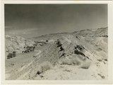
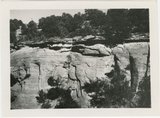
Unconformity between Moenkopi formation (lower part) and Shinarump conglomerate. Upper Chinle beds, middle top. Near mouth of Road Canyon. Kane County, UT. 1943
P0013 Herbert E. Gregory Photograph Collection
P0013n12_028_2877E
27
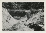
West wall of Seaman Wash
P0013 Herbert E. Gregory Photograph Collection
P0013n12_032_2880
28
Looking south, up dip, across West Clark Bench, Upper Jurassic and Dakota (butte), to the Paria Terrace, Navajo sandstone. Paria River, which passes through 'The Gap' is joined by Kaibab Creek. Kane County, UT. 1944
P0013 Herbert E. Gregory Photograph Collection
P0013n12_036_2883
29
Looking south (up dip) down the Paria River, which has widened its floor and dissected its borders in Upper Jurassic rocks (foreground) and cut a deep narrow canyon in the Navajo sandstone (background). Site of the abandoned Adairville. Kane County UT, 1944
P0013 Herbert E. Gregory Photograph Collection
P0013n12_038_2885
30
Flat lying Upper Jurassic (foreground) and Cretaceous strata bed abruptly upward against the Navajo on the flank of the East Kaibab monocline (left sky line). Table Cliffs (right sky line) is about 50 miles north. Paria Valley near Adairville. Kane County, UT. 1944
P0013 Herbert E. Gregory Photograph Collection
P0013n12_039_2886
31
Eroded flank of the East Kaibab monocline at the junction of Paria River and Cottonwood Creek (left center). The sequence is Navajo (left), upper Jurassic (largely eroded), Dakota, Tropic, and Straight Cliffs. Kane County, UT, 1944
P0013 Herbert E. Gregory Photograph Collection
P0013n12_040_2887
32
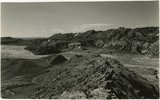
Looking south along Paria River from the mouth of Shurtz Gorge. Navajo sandstone in East Kaibab monocline is overlaid with decreasing dips by Upper Jurassic (banked against the Navajo), Dakota, and Tropic (foreground and left sky line). Erosion surface (middle distance) bevels upturned rocks. Kane County, UT, 1944
P0013 Herbert E. Gregory Photograph Collection
P0013n12_041_2888
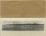
33
Panorama {c}. Flank of East Kaibab monocline, bordering alluvial floor of Paria Valley. Navajo sandstone (middle sky line), Upper Jurassic strata, and basal Cretaceous (left). Dips of 40 degrees decrease to 3 degrees within 1,000 feet. Kane County, UT, 1944
P0013 Herbert E. Gregory Photograph Collection
P0013n12_042_2891
34
Kaibab limestone (lower wall,left, breccia (marks unconformable contact), and basal Moenkopi limestone and shales. Mouth of Kaibab Gulch. Kane County, UT, 1944
P0013 Herbert E. Gregory Photograph Collection
P0013n12_047-048_2899
35
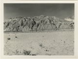
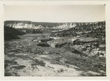
Mesa capped by Dakota sandstone eroded from upper Jurassic Winsor (?) formation. Head of Ash Creek. Kane County, UT
P0013 Herbert E. Gregory Photograph Collection
P0013n12_051_2903A
36
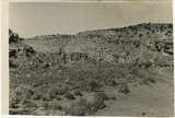
Section of the Shinarump Cliffs (middle distance), east of Pioneer Gap. Shinarump conglomerate exposed by erosion of Moenkopi formation below and the basal strata of the Chinle formation above. Upper Chinle sandstones form Vermilion Cliffs (background).
P0013 Herbert E. Gregory Photograph Collection
P0013n12_052B
37
Panorama--4 photographs. Blue Springs meadows. A former valley leading to Mammoth Creek blocked by basalts from Miller Knoll (right skyline) became a lake that eventually cut an outlet northward through the Brian Head formation (upper left). Garfield County, UT, 1944
P0013 Herbert E. Gregory Photograph Collection
P0013n12_068-069_pan
38
Brian Head formation, branch of Asay Creek; lies beneath basalt flows. Garfield County, UT, 1944
P0013 Herbert E. Gregory Photograph Collection
P0013n12_072_2935
39
Sevier River formation overlaid by basalt near mouth of Corral Creek on Highway 89, 2 miles east of Panguitch. Garfield County, UT. 1944
P0013 Herbert E. Gregory Photograph Collection
P0013n12_075_2940A
40
Bowers Knoll; Volcano viewed from northwest. Garfield County, UT. 1944
P0013 Herbert E. Gregory Photograph Collection
P0013n12_076_2940B
41
Herbert E. Gregory Book 13: Photographs taken on Yale Peruvian Expeditions, 1911-1915
P0013 Herbert E. Gregory Photograph Collection
P0013n13
42
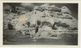
Ridge of uptilted strata
P0013 Herbert E. Gregory Photograph Collection
P0013n16_09_01
43
Navajo sandstone, part of White Cliffs, near head of Johnson Canyon, Kane Co., Utah, 1939
P0013 Herbert E. Gregory Photograph Collection
P0013n16_09_03
44
Card players, Paria Valley camp, 1943
P0013 Herbert E. Gregory Photograph Collection
P0013n16_11_01
45
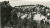
Starlight Canyon 1943
P0013 Herbert E. Gregory Photograph Collection
P0013n16_11_03
46
Bark Wash, Utah 1943
P0013 Herbert E. Gregory Photograph Collection
P0013n16_11_04
47
Kitchen Canyon, Utah 1943
P0013 Herbert E. Gregory Photograph Collection
P0013n16_11_05
48
Shinarump outcrop near Paria, 1943
P0013 Herbert E. Gregory Photograph Collection
P0013n16_11_07
49
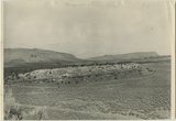
Paria Valley camp, 1943
P0013 Herbert E. Gregory Photograph Collection
P0013n16_11_09
50
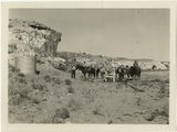
Herbert Gregory party at watering station in Paria Valley, Utah
P0013 Herbert E. Gregory Photograph Collection
P0013n16_11_10
26
-
50
of
3,426
<
1
2
3
4
5
6
7
8
9
10
>