|
|
Title | Collection Number And Name | Photo Number |
| 326 |
 |
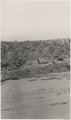
Basalt-capped mesa, Biddehoche, Ariz. (negative for photo G-68) | P0013 Herbert E. Gregory Photograph Collection | P0013n02_039_275_neg |
| 327 |
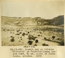 |
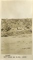
Basalt cap on Dolores (Triassic) on Holbrook-Keams Canyon road, 9± mi. south of Biddehoche, Arizona, 1909 (photo G-69) | P0013 Herbert E. Gregory Photograph Collection | P0013n02_040_276 |
| 328 |
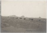 |
Volcanic necks; view looking southeast from Chandler's Ranch (30± mi. north-northeast of Winslow, Ariz.), toward Chimney Butte, 1909 (photo G-70) | P0013 Herbert E. Gregory Photograph Collection | P0013n02_040_277 |
| 329 |
 |
Volcanic necks; view looking southeast from Chandler's Ranch (30± mi. north-northeast of Winslow, Ariz.), toward Chimney Butte, 1909 (photo G-70) | P0013 Herbert E. Gregory Photograph Collection | P0013n02_040_277 |
| 330 |
 |
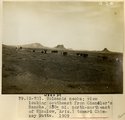
Pyramid Butte, Chandler's Ranch, 30± mi. north-northeast of Winslow, Ariz., 1909 (photo G-71) | P0013 Herbert E. Gregory Photograph Collection | P0013n02_041_278 |
| 331 |
 |
Pyramid Butte, Chandler's Ranch (negative for photo G-71) | P0013 Herbert E. Gregory Photograph Collection | P0013n02_041_278_neg |
| 332 |
 |
Montezuma's Chair, a volcanic neck, northwest of Chandler's, 30± mi. north-northwest of Winslow, Ariz., 1909 (photo G-72) | P0013 Herbert E. Gregory Photograph Collection | P0013n02_041_279 |
| 333 |
 |
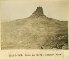
Same as G-72, nearer view: a volcanic neck, northwest of Chandler's Ranch (photo G-73) | P0013 Herbert E. Gregory Photograph Collection | P0013n02_041_280 |
| 334 |
 |
Same as G-72, nearer view: a volcanic neck, northwest of Chandler's Ranch (photo G-73) | P0013 Herbert E. Gregory Photograph Collection | P0013n02_041_280 |
| 335 |
 |
Same as G-72 (Montezuma's Chair, negative for photo G-73) | P0013 Herbert E. Gregory Photograph Collection | P0013n02_041_280_neg |
| 336 |
 |
Same as G-72, nearer view: Montezuma's Chair, a volcanic neck, northwest of Chandler's Ranch (photo G-74) | P0013 Herbert E. Gregory Photograph Collection | P0013n02_042_281 |
| 337 |
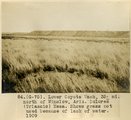 |
Lower Coyote Wash, 35± mi. north of Winslow, Ariz. Dolores (Triassic) Mesa. Shows grass not used because of lack of water, 1909 (photo G-75) | P0013 Herbert E. Gregory Photograph Collection | P0013n02_042_282 |
| 338 |
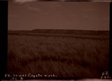 |
Lower Coyote Wash (negative for photo G-75) | P0013 Herbert E. Gregory Photograph Collection | P0013n02_042_282_neg |
| 339 |
 |
Lower Oraibi Wash looking west from Little Burro Springs, Ariz., 1909 (photo G-76) | P0013 Herbert E. Gregory Photograph Collection | P0013n02_043_283 |
| 340 |
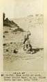 |
Hand drill at work, Lower Oraibi Wash, 4± mi. beow Burro Springs, Ariz., 1909 (photo G-78) | P0013 Herbert E. Gregory Photograph Collection | P0013n02_043_284 |
| 341 |
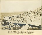 |
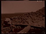
Big Burro Springs, Arizona, 1909 (photo G-77) | P0013 Herbert E. Gregory Photograph Collection | P0013n02_043_285 |
| 342 |
 |
Big Burro Springs, Arizona, 1909 (negative for photo G-77) | P0013 Herbert E. Gregory Photograph Collection | P0013n02_043_285_neg |
| 343 |
 |
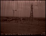
Windmills with points driven into alluvial sand, 10± miles north of Holbrook, Ariz., 1909 (photo G-79) | P0013 Herbert E. Gregory Photograph Collection | P0013n02_044_286 |
| 344 |
 |
Windmills no. of Holbrook, Ariz., 1909 (negative for photo G-77) | P0013 Herbert E. Gregory Photograph Collection | P0013n02_044_286_neg |
| 345 |
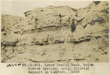 |
Lower Oraibi Wash, below Burro Springs, Ariz., alluvial deposit on bedrock, 1909 (photo G-80) | P0013 Herbert E. Gregory Photograph Collection | P0013n02_044_287 |
| 346 |
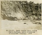 |
Lower Oraibi Wash, below Burro Springs, Ariz., character of alluvial filling, 1909 (photo G-81) | P0013 Herbert E. Gregory Photograph Collection | P0013n02_045_288 |
| 347 |
 |
Lower Oraibi Wash (negative of G-81) | P0013 Herbert E. Gregory Photograph Collection | P0013n02_045_288_neg |
| 348 |
 |
Same as G-81 (alluvial beds at Lower Oraibi Wash below Burro Springs, Arizona, photo G-82) | P0013 Herbert E. Gregory Photograph Collection | P0013n02_045_289 |
| 349 |
 |
Same as G-81 (alluvial beds at Lower Oraibi Wash below Burro Springs, Arizona, photo G-82) | P0013 Herbert E. Gregory Photograph Collection | P0013n02_045_289 |
| 350 |
 |
Same as G-81 (alluvial beds at Lower Oraibi Wash below Burro Springs, Arizona, negative for photo G-82) | P0013 Herbert E. Gregory Photograph Collection | P0013n02_045_289_neg |