|
|
Title | Collection Number And Name | Photo Number |
| 226 |
 |
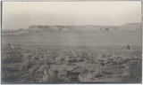
Same as G176 (Barohoini Bridge from upstream, nearer view, 1910, Photo G178) | P0013 Herbert E. Gregory Photograph Collection | P0013n04_58_0607 |
| 227 |
 |
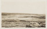
Same as G176 (Rainbow Bridge, distance 1/4+ mile from upstream, 1910 (Photo G177) | P0013 Herbert E. Gregory Photograph Collection | P0013n04_57_0605 |
| 228 |
 |
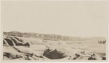
Same as G178 (Barohoini Bridge from upstream, 1910, Photo N-M99) | P0013 Herbert E. Gregory Photograph Collection | P0013n04_58_0608 |
| 229 |
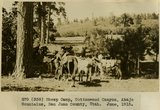 |
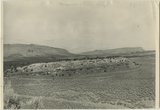
Sheep Camp, Cottonwood Canyon, Abajo Mountains, San Juan County, Utah. June, 1915. | P0013 Herbert E. Gregory Photograph Collection | P0013n08_036_1379 |
| 230 |
 |
Shinarump 2± mi. below Black Point (Photo N-M177) | P0013 Herbert E. Gregory Photograph Collection | P0013n06_083_0994 |
| 231 |
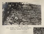 |
Trail, Pah Ute Canyon; massive, bedded Dolores (Photo G369) | P0013 Herbert E. Gregory Photograph Collection | P0013n06_046_0919 |
| 232 |
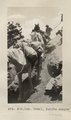 |
Trail, PahUte canyon (Photo N-M162) | P0013 Herbert E. Gregory Photograph Collection | P0013n06_045_0918 |
| 233 |
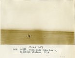 |
Wind-made lake basin, Moenkopi plateau, 1914 | P0013 Herbert E. Gregory Photograph Collection | P0013n07_063_1112 |
| 234 |
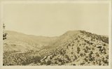 |
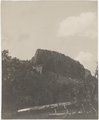
Allen Canyon country outer slope of Comb monocline. San Juan County, UT, 1925. Wall of ridge includes Moenkopi and Chinle, head of Whiskers Creek | P0013 Herbert E. Gregory Photograph Collection | P0013n09_052_1819 |
| 235 |
 |
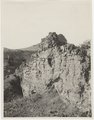
Butte, 3± mi. west of Stiles Ranche (Photo G238) | P0013 Herbert E. Gregory Photograph Collection | P0013n05_43_0739 |
| 236 |
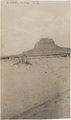 |
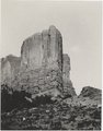
Butte, LaPlata on Dolores, 12± mi. south of Oljato, Utah. Agathla Needle in distance, 1910 | P0013 Herbert E. Gregory Photograph Collection | P0013n04_33_0562A |
| 237 |
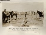 |
Camp in Pueblo Colorado Wash. Case digging for water (Photo N-M167) | P0013 Herbert E. Gregory Photograph Collection | P0013n06_063_0953 |
| 238 |
 |
Canyon de Chelly. Cross-bedding (III-9 just like this) (Photo G374) | P0013 Herbert E. Gregory Photograph Collection | P0013n06_049_0925 |
| 239 |
 |
Dike (diabase?), Stiles Ranche, Moqui Buttes region, AZ. 1911 (Photo G235) | P0013 Herbert E. Gregory Photograph Collection | P0013n05_40_0736 |
| 240 |
 |
Grass between Monument Pass and Oljato, Utah. Moencopie strata (capped by Shinarump?) in distance, 1910 (Photo N-M82) | P0013 Herbert E. Gregory Photograph Collection | P0013n04_14_0537 |
| 241 |
 |
Herbert E. Gregory Book 11: Colorado Plateau, 1938-1942 | P0013 Herbert E. Gregory Photograph Collection | P0013n11 |
| 242 |
 |
LaPlata cliff, 6 mi. south of Moore's. VI, 38. 1911 (Photo G210) | P0013 Herbert E. Gregory Photograph Collection | P0013n05_16_0697 |
| 243 |
 |
Lava cliffs near Whiskey Creek (Palisades). Heald, photo. 1911 (Photo N-M130) | P0013 Herbert E. Gregory Photograph Collection | P0013n05_83_0808 |
| 244 |
 |
Mesa capped by Dakota sandstone eroded from upper Jurassic Winsor (?) formation. Head of Ash Creek. Kane County, UT | P0013 Herbert E. Gregory Photograph Collection | P0013n12_051_2903A |
| 245 |
 |
Panorama, Red Wall and Baigaiche, looking across Red Lake (Photo G-378-380) | P0013 Herbert E. Gregory Photograph Collection | P0013n06_052_0931 |
| 246 |
 |
Same as Photo G240 (Chimney Butte, Photo G241) | P0013 Herbert E. Gregory Photograph Collection | P0013n05_47_0742 |
| 247 |
 |
Section of the Shinarump Cliffs (middle distance), east of Pioneer Gap. Shinarump conglomerate exposed by erosion of Moenkopi formation below and the basal strata of the Chinle formation above. Upper Chinle sandstones form Vermilion Cliffs (background). | P0013 Herbert E. Gregory Photograph Collection | P0013n12_052B |
| 248 |
 |
Shanto Springs (photograph from Herbert E. Gregory Book 4: Navajo, San Juan, 1910) | P0013 Herbert E. Gregory Photograph Collection | P0013n04_37_0573 |
| 249 |
 |
View from "Beast" dike north across Red Lake (Photo G391) | P0013 Herbert E. Gregory Photograph Collection | P0013n06_060_0946 |
| 250 |
 |
View looking northeast up Black Creek from "Beast" dike (Photo G392) | P0013 Herbert E. Gregory Photograph Collection | P0013n06_060_0947 |