|
|
Title | Collection Number And Name | Photo Number |
| 226 |
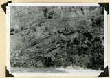 |
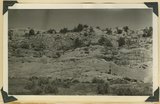
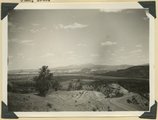
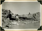
Contact of Triassic and Permian (beds in wall wrinkled at base). Cherty limestone lower left. Camp Creek. Iron County, UT. 1941 | P0013 Herbert E. Gregory Photograph Collection | P0013n11_159_2774 |
| 227 |
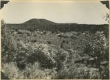 |
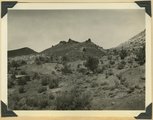
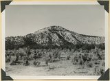
Corral Knoll volcanic cone, Kanab Valley, Kane County, Carmel limestone covered with lava (foreground), Cretaceous cliffs distance, Kane Co., UT. 1939 | P0013 Herbert E. Gregory Photograph Collection | P0013n11_085_2666 |
| 228 |
 |
Cottonwood trees buried by sand dunes; trunks reexposed by recent excavations of alluvial valley fill, Short Creek, Mohave County, AZ, 1939 | P0013 Herbert E. Gregory Photograph Collection | P0013n11_077_2655 |
| 229 |
 |
Cougar Mountain fault. Springdale member of Chinle (lower left) abutting against base of Navajo (lower right), Washington County, UT, 1939 | P0013 Herbert E. Gregory Photograph Collection | P0013n11_051_2608 |
| 230 |
 |
Cowboy Butte 2 miles north of Fredonia. Moenkopi (Shnabkaib member at base) and Shinarump, Coconino County, AZ. 1939 | P0013 Herbert E. Gregory Photograph Collection | P0013n11_103_2694 |
| 231 |
 |
Divide dike basalt intruded in Moenkopi beds, head of Workman Wash, Washington County, UT, 1939 | P0013 Herbert E. Gregory Photograph Collection | P0013n11_074_2650 |
| 232 |
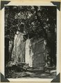 |
Door of "Winsor Castle," Pipe Springs, Mohave County, Ariz. 1939 | P0013 Herbert E. Gregory Photograph Collection | P0013n11_101_2691 |
| 233 |
 |
East Creek Valley, Union Pacific pump house | P0013 Herbert E. Gregory Photograph Collection | P0013n11_105_2697 |
| 234 |
 |
Edge of basalt flow over eroded Moenkopi along highway west of Grafton, Washington County, UT, 1939 | P0013 Herbert E. Gregory Photograph Collection | P0013n11_043_2594 |
| 235 |
 |
Entrada formation. Gypsiferous Curtis at top. Near mouth of Crystal Creek, Washington County, UT, 1939 | P0013 Herbert E. Gregory Photograph Collection | P0013n11_049_2605 |
| 236 |
 |
Entrada sandstone (bottom) in contact with shales and gypsum of Curtis formation, Paria Valley 4 miles south of Cannonville, Kane County, UT. 1939 | P0013 Herbert E. Gregory Photograph Collection | P0013n11_040_2589 |
| 237 |
 |
Entrada, Curtis, and Winsor formation overlain by Dakota (extreme top), Alton-Skutumpah road, Kane County, UT, 1939 | P0013 Herbert E. Gregory Photograph Collection | P0013n11_079_2659 |
| 238 |
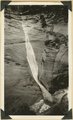 |
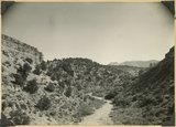
Ephemeral waterfall, disappears about half hour after rain. Pine Creek, Zion National Park, 1937 | P0013 Herbert E. Gregory Photograph Collection | P0013n11_022_2556 |
| 239 |
 |
Eroded alluvial fill 60 feet thick in Kanab Creek. In 1884 stream ran at top of terrace, Kane Co., Utah, 1939 | P0013 Herbert E. Gregory Photograph Collection | P0013n11_068_2640 |
| 240 |
 |
Eroded edge of basalt flow from Bald Knoll. White Cliffs, Navajo sandstone (upper right); middle Johnson Canyon. Kane County, UT, 1940 | P0013 Herbert E. Gregory Photograph Collection | P0013n11_120_2710 |
| 241 |
 |
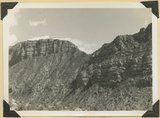
Erosion features near the head of Taylor Creek, towers and walls of Navajo sandstone overlaid by Carmel limestone and lavas (top right and center). Washington County, UT, 1940 | P0013 Herbert E. Gregory Photograph Collection | P0013n11_141_2738 |
| 242 |
 |
Erosion of Cretaceous beds in Paria Valley east of Tropic; Wasatch formation on horizon. View looking east near mouth of Henderson Valley. Garfield County, UT. 1940 | P0013 Herbert E. Gregory Photograph Collection | P0013n11_107_2698 |
| 243 |
 |
Erosion on Mancos shales, branch of Fremont River above Cainesville. Wayne County, UT | P0013 Herbert E. Gregory Photograph Collection | P0013n11_036_2584 |
| 244 |
 |
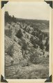
Erosion remnants in upper (white) part of Wasatch formation: limestone and conglomerate. Castle Wash an upper tributary to Sevier River. Kane County, UT, 1940 | P0013 Herbert E. Gregory Photograph Collection | P0013n11_126_2716 |
| 245 |
 |
Erosion surface at edge of Vermillion Cliffs west of Pipe Springs, Mohave County, AZ. Streams cross Sevier fault from downthrow to upthrow side. 1939 | P0013 Herbert E. Gregory Photograph Collection | P0013n11_102_2693 |
| 246 |
 |
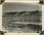
Erosion surface on lower Chinle beds at base of Vermillion Cliffs, traversed by Kanab Creek (left center), Kane County, UT. 1939 | P0013 Herbert E. Gregory Photograph Collection | P0013n11_069_2642 |
| 247 |
 |
Erosion surface produced by bevelling Chinle strata at the base of Vermillion Cliffs south of Cane Beds, Mohave County, AZ, 1939 | P0013 Herbert E. Gregory Photograph Collection | P0013n11_073_2648 |
| 248 |
 |
Falls in Kanab Creek near Corral Knoll. Carmel formation. Ancient channel of the Kanab filled with alluvium. Kane County, UT, 1939 | P0013 Herbert E. Gregory Photograph Collection | P0013n11_103_2695 |
| 249 |
 |
Fault at Mt. Carmel Junction, looking southeast. Carmel limestone on upthrown side (middle); Entrada (foreground). Kane County, UT, 1939 | P0013 Herbert E. Gregory Photograph Collection | P0013n11_037_2585 |
| 250 |
 |
Fault in Jurassic formations 3 miles south of Mt. Carmel. Carmel limestone (left). Entrada and Carmel (right). Elkheart Cliffs (Navajo) (upper right). Kane County, UT, 1939 | P0013 Herbert E. Gregory Photograph Collection | P0013n11_091_2674 |