Home
Browse
Ask Us
Chat
Harmful Language Statement
Log in
Photo Archives
Advanced Search
About
Over 70,000 photos covering a variety of topics from Marriott Library Special Collections
Year
1867
1868
1869
1870
1871
1872
1873
1874
1875
1876
1877
1878
1879
1880
1881
1882
1883
1884
1885
1886
1887
1888
1889
1890
1891
1892
1893
1894
1895
1896
1897
1898
1899
1900
1901
1902
1903
1904
1905
1906
1907
1908
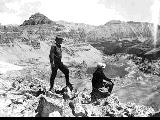
1909
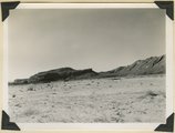
1910
1911
1912
1913
1914
1915
1916
1917
1918
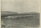
1919
1920
1921
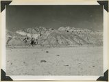
1922
1923
1924
1925
1926
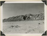
1927
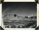
1928
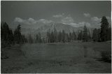
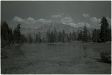
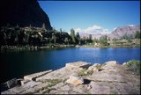
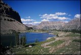
1929
1930
1931
1932
1933
1934
1935
1936
1937
1938
1939
1940
1941
1942
1943
1944
1945
1946
1947
1948
1949
1950
1951
1952
1953
1954
1955
1956
1957
1958
1959
1960
1961
1962
1963
1964
1965
1966
1967
1968
1969
1970
1971
1972
1973
1974
1975
1976
1977
1978
1979
1980
1981
1982
1983
1984
1985
1986
1987
1988
1989
1990
1991
1992
1993
1994
1995
1996
1997
1998
1999
2000
2001
TO
1867
1868
1869
1870
1871
1872
1873
1874
1875
1876
1877
1878
1879
1880
1881
1882
1883
1884
1885
1886
1887
1888
1889
1890
1891
1892
1893
1894
1895
1896
1897
1898
1899
1900
1901
1902
1903
1904
1905
1906
1907
1908
1909
1910
1911
1912
1913
1914
1915
1916
1917
1918
1919
1920
1921
1922
1923
1924
1925
1926
1927
1928
1929
1930
1931
1932
1933
1934
1935
1936
1937
1938
1939
1940
1941
1942
1943
1944
1945
1946
1947
1948
1949
1950
1951
1952
1953
1954
1955
1956
1957
1958
1959
1960
1961
1962
1963
1964
1965
1966
1967
1968
1969
1970
1971
1972
1973
1974
1975
1976
1977
1978
1979
1980
1981
1982
1983
1984
1985
1986
1987
1988
1989
1990
1991
1992
1993
1994
1995
1996
1997
1998
1999
2000
2001
Type
Image
104
Image/StillImage
12
Text
2
Format
image/jpeg
129
application/pdf
21
Collection Name
Hope A. Hilton
33
Herbert E. Gregory
25
Bear River Portfolio
23
Emigration Canyon History
20
Wallace Stegner
12
Hortense Redd Erickson
6
Mickey Ibarra
4
Utah Test and Training Range
3
Wasatch Mountain Club
3
Alpenbock Climbing Club
2
Gary Dean Brown
2
Salt Lake Chamber of Commerce photograph collection
2
Sherm Lloyd
2
Charles H. Andrus photograph collection
1
Flora James Barson
1
Ivy Baker Priest
1
Olive Woolley Burt
1
Oquirrh School
1
Rocky Mountain Power Company
1
Wanda Clayton Thomas
1
More
Filters:
Collection:
"uum_map"
51
-
75
of
150
<
1
2
3
4
5
6
>
Gallery view
Number of results to display per page
10
25
50
100
200
Sort by Relevance
Sort by Title A-Z
Sort by Title Z-A
Sort by Date Ascending
Sort by Date Descending
Sort by Last Modified Ascending
Sort by Last Modified Descending
Sort by Photo Number
Title
Collection Number And Name
Photo Number
51
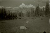
Hikers on Hayden Peak overlooking Middle Basin in the Uinta Mountains [6]
P0004 Wasatch Mountain Club Photograph Collection
P0004n0671
52
Middle East street scene
P0053 Hortense Redd Erickson lantern slide collection, 1920-1929
P0053n01_G022
53
Keet Seel, cliff ruins east middle branch of Sagy (Towanaoche) canyon, Ariz., 1910 (Photo G165)
P0013 Herbert E. Gregory Photograph Collection
P0013n04_37_0574
54
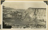
Section of the Shinarump Cliffs (middle distance), east of Pioneer Gap. Shinarump conglomerate exposed by erosion of Moenkopi formation below and the basal strata of the Chinle formation above. Upper Chinle sandstones form Vermilion Cliffs (background).
P0013 Herbert E. Gregory Photograph Collection
P0013n12_052B
55
View looking east across Parunuweap Valley near Mt. Carmel. Distance Elkheart Cliffs (Navajo capped by Carmel) on upthrown side of Sevier fault; middle distance erosion surface in Carmel and other Jurassic. Kane County, Utah, 1932.
P0013 Herbert E. Gregory Photograph Collection
P0013n10_116_2283
56
Looking down Notch Canyon from East Point, Elk Ridge, toward Chimney Park. Cottonwood Canyon in middle distance. Buttes of Navajo beyond Shay Mountains in distance. San Juan County, UT, 1928
P0013 Herbert E. Gregory Photograph Collection
P0013n09_125_1964
57
Looking down Notch Canyon from East Point, Elk Ridge, toward Chimney Park. Cottonwood Canyon in middle distance. Buttes of Navajo beyond Shay Mountains in distance. San Juan County, UT, 1928
P0013 Herbert E. Gregory Photograph Collection
P0013n09_125_1964
58
Panorama {a}. Flank of East Kaibab monocline, bordering alluvial floor of Paria Valley. Navajo sandstone (middle sky line), Upper Jurassic strata, and basal Cretaceous (left). Dips of 40 degrees decrease to 3 degrees within 1,000 feet. Kane County, UT, 1944
P0013 Herbert E. Gregory Photograph Collection
P0013n12_042_2889
59
Panorama {b}. Flank of East Kaibab monocline, bordering alluvial floor of Paria Valley. Navajo sandstone (middle sky line), Upper Jurassic strata, and basal Cretaceous (left). Dips of 40 degrees decrease to 3 degrees within 1,000 feet. Kane County, UT, 1944
P0013 Herbert E. Gregory Photograph Collection
P0013n12_042_2890
60
Panorama {c}. Flank of East Kaibab monocline, bordering alluvial floor of Paria Valley. Navajo sandstone (middle sky line), Upper Jurassic strata, and basal Cretaceous (left). Dips of 40 degrees decrease to 3 degrees within 1,000 feet. Kane County, UT, 1944
P0013 Herbert E. Gregory Photograph Collection
P0013n12_042_2891
61
Panorama {d}. Flank of East Kaibab monocline, bordering alluvial floor of Paria Valley. Navajo sandstone (middle sky line), Upper Jurassic strata, and basal Cretaceous (left). Dips of 40 degrees decrease to 3 degrees within 1,000 feet. Kane County, UT, 1944
P0013 Herbert E. Gregory Photograph Collection
P0013n12_043_2892
62
View looking northeast across Kolob Terrace. Basalt (foreground), Cretaceous trenched by Crystal Creek (middle), Pink Cliffs-Wasatch (skyline), lower east slope of Black Mountain (extreme left), 'The Gap,' twin peaks (right skyline), stands just south of Navajo Lake. Iron County, UT, 1942
P0013 Herbert E. Gregory Photograph Collection
P0013n11_188_2827
63
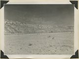
Middle Basin pond (negative)
P2162 Bear River Portfolio by Craig Denton
P2162n01_05_010
64
Middle Basin pond (negative)
P2162 Bear River Portfolio by Craig Denton
P2162n01_05_011
65
Page 2
66
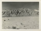
Spread Eagle Mountain, Middle Basin (negative)
P2162 Bear River Portfolio by Craig Denton
P2162n01_06_021
67
Spread Eagle Mountain, Middle Basin (negative)
P2162 Bear River Portfolio by Craig Denton
P2162n01_06_022
68
Looking west across Panguitch. Sevier River formation (foreground), alluvium (middle distance), basalt (left center), and pyroclastic slopes leading to Little Creek Peak (background), on the east wall of Bear Valley. Garfield County, UT, 1944
P0013 Herbert E. Gregory Photograph Collection
P0013n12_065_2923
69
Panorama {c}. Flank of East Kaibab monocline, bordering alluvial floor of Paria Valley. Navajo sandstone (middle sky line), Upper Jurassic strata, and basal Cretaceous (left). Dips of 40 degrees decrease to 3 degrees within 1,000 feet. Kane County, UT, 1944
P0013 Herbert E. Gregory Photograph Collection
P0013n12_042_2891
70
Panorama {e}. Flank of East Kaibab monocline, bordering alluvial floor of Paria Valley. Navajo sandstone (middle sky line), Upper Jurassic strata, and basal Cretaceous (left). Dips of 40 degrees decrease to 3 degrees within 1,000 feet. Kane County, UT, 1944
P0013 Herbert E. Gregory Photograph Collection
P0013n12_043_2893
71
View looking east across north end of No Man's Mesa, composed of Navajo sandstone partly capped by Carmel limestone. Park Wash (foreground) area drained by Kitchen Canyon tributary to Paria River (middle background). Panoramic with no. 887. Kane County, UT, 1940
P0013 Herbert E. Gregory Photograph Collection
P0013n11_109_2700
72
Zion Park Cliffs, from Shinarump bench, near base of Smithsonian Butte. Virgin River in middle distance; West Temple center distance; at the right Bridge Mountain, East Temple, The Twin Brothers, and Mountain of the Sun. Zion National Park, Utah, 1936.
P0013 Herbert E. Gregory Photograph Collection
P0013n10_205_2458
73
McPheters Lake, Middle Basin [04]
P2162 Bear River Portfolio by Craig Denton
P2162n04_13_004
74
McPheters Lake, Middle Basin [05]
P2162 Bear River Portfolio by Craig Denton
P2162n04_13_005
75
McPheters Lake, Middle Basin [06]
P2162 Bear River Portfolio by Craig Denton
P2162n04_13_006
51
-
75
of
150
<
1
2
3
4
5
6
>