Home
Browse
Ask Us
Chat
Harmful Language Statement
Log in
Photo Archives
Advanced Search
About
Over 90,000 photos covering a variety of topics from Marriott Library Special Collections.
Year
1820
1821
1822
1823
1824
1825
1826
1827
1828
1829
1830
1831
1832
1833
1834
1835
1836
1837
1838
1839
1840
1841
1842
1843
1844
1845
1846
1847
1848
1849
1850
1851
1852
1853
1854
1855
1856
1857
1858
1859
1860
1861
1862
1863
1864
1865
1866
1867
1868
1869
1870
1871
1872
1873
1874
1875
1876
1877
1878
1879
1880
1881
1882
1883
1884
1885
1886
1887
1888
1889
1890
1891
1892
1893
1894
1895
1896
1897
1898
1899
1900
1901
1902
1903
1904
1905
1906
1907
1908
1909
1910
1911
1912
1913
1914
1915
1916
1917
1918
1919
1920
1921
1922
1923
1924
1925
1926
1927
1928
1929
1930
1931
1932
1933
1934
1935
1936
1937
1938
1939
1940
1941
1942
1943
1944
1945
1946
1947
1948
1949
1950
1951
1952
1953
1954
1955
1956
1957
1958
1959
1960
1961
1962
1963
1964
1965
1966
1967
1968
1969
1970
1971
1972
1973
1974
1975
1976
1977
1978
1979
1980
1981
1982
1983
1984
1985
1986
1987
1988
1989
1990
1991
1992
1993
1994
1995
1996
1997
1998
1999
2000
2001
2002
TO
1820
1821
1822
1823
1824
1825
1826
1827
1828
1829
1830
1831
1832
1833
1834
1835
1836
1837
1838
1839
1840
1841
1842
1843
1844
1845
1846
1847
1848
1849
1850
1851
1852
1853
1854
1855
1856
1857
1858
1859
1860
1861
1862
1863
1864
1865
1866
1867
1868
1869
1870
1871
1872
1873
1874
1875
1876
1877
1878
1879
1880
1881
1882
1883
1884
1885
1886
1887
1888
1889
1890
1891
1892
1893
1894
1895
1896
1897
1898
1899
1900
1901
1902
1903
1904
1905
1906
1907
1908
1909
1910
1911
1912
1913
1914
1915
1916
1917
1918
1919
1920
1921
1922
1923
1924
1925
1926
1927
1928
1929
1930
1931
1932
1933
1934
1935
1936
1937
1938
1939
1940
1941
1942
1943
1944
1945
1946
1947
1948
1949
1950
1951
1952
1953
1954
1955
1956
1957
1958
1959
1960
1961
1962
1963
1964
1965
1966
1967
1968
1969
1970
1971
1972
1973
1974
1975
1976
1977
1978
1979
1980
1981
1982
1983
1984
1985
1986
1987
1988
1989
1990
1991
1992
1993
1994
1995
1996
1997
1998
1999
2000
2001
2002
Type
Image
2,002
Image/StillImage
467
Format
image/jpeg
2,655
application/pdf
210
Collection Name
Shipler Studio
1,030
Sheepherding
227
Olive Woolley Burt
165
Utah Schools photograph collection
112
Wasatch Mountain Club
110
Edward Hunter Family
73
George D. Pyper
69
Salt Lake Chamber of Commerce photograph collection
68
Wallace and Mary Doi
60
Lyman P. Hunter
52
J. Willard and Alice Sheets Marriott
50
Frederick J. Pack
46
Stephanie Young Merzel
45
Clifford Percy Evans
44
Environmental Geology in Utah
43
Ivor Sharp
39
Rocky Mountain Power Company
36
William M. Purdy
34
Herbert E. Gregory
32
MX photograph collection
30
Robert Heiner Garff
29
Alvin G. and Lena M. Pack
27
Helen Bowring Ure photograph collection
26
Gary Dean Brown
23
Greek Archives
22
Elbert Thomas
20
C. Lowell Lees
19
Utah interurban railroads
19
John Stockert
18
Mickey Ibarra
17
Joseph Kingsbury
16
Waldo Wilcox
15
Lynn Larsen
14
Southern Slavic
13
Charles Kelly
12
Frank Filkins
12
William Dawson
12
United States Fuel Corporation
11
Utah Railroads
9
Everett Ruess Family
8
The Triumphal Return of the Utah Volunteers
8
American Civil Liberties Union of Utah
7
Glade Peterson photograph collection
6
Lowell Lindsay Bennion
6
Orange A. Olsen photograph collection
6
Portrait
6
Clarence Stevenson
5
Henry Y. Kasai
5
Julia Farnsworth Lund Wassmer
5
Dr Robert Starr Waite
4
G. Bennet Larson
4
Gibb R. Madsen
4
Luretta Young
4
Miles Pratt Romney
4
Richard E. Westwood Photograph Collection
4
Transportation photograph collection
4
Wallace F. Bennett
4
Cheves Walling
3
Gus Scott
3
Intermountain Conference on Children's Literature
3
John W. Summerhays
3
Ole Pettit
3
Topaz, Utah and Hispanics in Utah films, 1940-1990
3
A. Wally Sandack
2
Alpine Mountain Club
2
Anne Marie Fox Felt
2
Brigham Young Family
2
Charles Neal
2
Frederick Hoffman Wood
2
Italian
2
LDS Church History
2
Leo Leonard
2
Lowry Nelson
2
Maurice Abravanel
2
Reva Beck Bosone
2
Wallace Stegner
2
Walter H. and Ann S. Huish photograph collection
2
William Dawson photograph collection
2
William F. Bulkley
2
A. Selden Millward
1
Allen Publishing Company
1
American Red Cross
1
Blanche Kendall McKey
1
Deseret Livestock Company
1
Edward P. Jennings
1
Ezra T. Clark photograph collection
1
Hampton C. Godbe
1
Hiram B. Clawson
1
John Hamilton Morgan
1
Mary Jane Mount Tanner
1
Rosezella Dalton Hardy
1
S.J. Quinney
1
Salt Lake Oratorio Society photograph collection
1
Sherm Lloyd
1
Sonia Johnson
1
Standley Hunter Rich
1
Stanley Murdock
1
Utah Flood Survey
1
Utah Humanities Research Foundation
1
Utah Test and Training Range
1
Western and Mormon stereograph collection
1
More
Filters:
Collection:
"uum_map"
Spatial Coverage:
"Utah"
2826
-
2850
of
2,865
<
106
107
108
109
110
111
112
113
114
115
>
Gallery view
Number of results to display per page
10
25
50
100
200
Sort by Relevance
Sort by Title A-Z
Sort by Title Z-A
Sort by Date Ascending
Sort by Date Descending
Sort by Last Modified Ascending
Sort by Last Modified Descending
Sort by Photo Number
Title
Collection Number And Name
Photo Number
2826
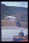
Looking downstream from the crest of the same earthfill dam (p1274n026). Note urban area at mouth of canyon.
P1274 Environmental Geology and Geologic Hazards in Utah Photograph Collection
p1274n027
2827
The old drainage below the dam through the city is now the site of numerous houses. Severe destruction would result from the dam failure.
P1274 Environmental Geology and Geologic Hazards in Utah Photograph Collection
p1274n028
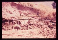
2828
Looking across a dam towards a massive ancient landslide. Recent highway construction has rejuvenated landsliding just below the spillway; note receding hillside under arrow.
P1274 Environmental Geology and Geologic Hazards in Utah Photograph Collection
p1274n029
2829
View along the highway traffic lanes and the dam abutment at the newly created cut slope.
P1274 Environmental Geology and Geologic Hazards in Utah Photograph Collection
p1274n030
2830
Same view showing notch in cut slope, the result of a failure onto the road soon after opening to traffic (p1274n030). Landsliding is predictable.
P1274 Environmental Geology and Geologic Hazards in Utah Photograph Collection
p1274n031
2831
Front end view of the slide (p1274n030).
P1274 Environmental Geology and Geologic Hazards in Utah Photograph Collection
p1274n032
2832
Reservoir slopes failing just upstream from dam. A failure overtopping the road would cause turbidity in the drinking water for a large city since the intake is directly downstream and in line with the current.
P1274 Environmental Geology and Geologic Hazards in Utah Photograph Collection
p1274n033
2833
Blasting for an interstate highway in the immediate vicinity of a dam. Concrete railing of dam appears in lower right corner. Vibrations, whether natural (earthquake) or manmade, may damage structures on sensitive foundations.
P1274 Environmental Geology and Geologic Hazards in Utah Photograph Collection
p1274n034
2834
Excavation for a covered distribution reservoir is pointed out in the photo. Note that drainages have been truncated. Reservoir is in an urban area with considerable development downslope. Geologic materials comprising the site are unstable. Geologic faults are mapped bounding the site, and springs issue from excavation walls and floor.
P1274 Environmental Geology and Geologic Hazards in Utah Photograph Collection
p1274n035
2835
Failure of ground bordering on a covered distribution reservoir. Hammer provides scale on displacement scarp.
P1274 Environmental Geology and Geologic Hazards in Utah Photograph Collection
p1274n036
2836
Landslide of bedrock onto highway; a frequent problem for highway maintenance, sometimes necessitating blasting of large bedrock blocks.
P1274 Environmental Geology and Geologic Hazards in Utah Photograph Collection
p1274n039
2837
Crack down the highway centerline, showing displacement. U.S. 6 near Colton.
P1274 Environmental Geology and Geologic Hazards in Utah Photograph Collection
p1274n040
2838
Incipient landslide failure on subdivision road. Note characteristic arcuate configuration of ground surface, also patching along crack.
P1274 Environmental Geology and Geologic Hazards in Utah Photograph Collection
p1274n046
2839
Dropping of street which crossed old landslide failure plane. Note break in slope towards distance in line with fresh scarplet across street. Utility pole is seated along the slide plane.
P1274 Environmental Geology and Geologic Hazards in Utah Photograph Collection
p1274n047
2840
Landslide scarplet "getting closer to home" in mountain subdivision.
P1274 Environmental Geology and Geologic Hazards in Utah Photograph Collection
p1274n049
2841
Failure of front yard before completion of home construction in mountain subdivision.
P1274 Environmental Geology and Geologic Hazards in Utah Photograph Collection
p1274n050
2842
Characteristic arcuate crack pattern in basement of house. Both vertical and lateral displacement is apparent.
P1274 Environmental Geology and Geologic Hazards in Utah Photograph Collection
p1274n051
2843
In the same house; the ceiling is clearly distressed.
P1274 Environmental Geology and Geologic Hazards in Utah Photograph Collection
p1274n052
2844
Ogden Standard Examiner newspaper photograph of mudslide encroaching into dining room.
P1274 Environmental Geology and Geologic Hazards in Utah Photograph Collection
p1274n054
2845
Weber Basin Job Corpsmen digging out mudslide debris from hillside house.
P1274 Environmental Geology and Geologic Hazards in Utah Photograph Collection
p1274n055
2846
Party of people viewing large landslide mass. Slide plane (surface along which mass of earth moved) is evident in photo half way down the exposed wall, sloping towards the party.
P1274 Environmental Geology and Geologic Hazards in Utah Photograph Collection
p1274n058
2847
Closeup of slide plane. Note deposition of white calcium carbonate by groundwater along slide plane. Arrow points to smooth, slickensided (grooved) surface on underside of sliding mass.
P1274 Environmental Geology and Geologic Hazards in Utah Photograph Collection
p1274n059
2848
Hillside subdivision in landslide terrain. Terrain in background has slid in the past. Instrument for measuring ground displacement is housed in box in foreground. White rain gage sits atop instrument housing.
P1274 Environmental Geology and Geologic Hazards in Utah Photograph Collection
p1274n063
2849
Undisturbed hillside failing because of lateral and vertical erosion by creek. Debris is continuously removed from toe of sliding hillside by the creek.
P1274 Environmental Geology and Geologic Hazards in Utah Photograph Collection
p1274n064
2850
Well points (small diameter water wells) used to dewater a hillside in loose sand to stabilize it after cut was made for roadway.
P1274 Environmental Geology and Geologic Hazards in Utah Photograph Collection
p1274n066
2826
-
2850
of
2,865
<
106
107
108
109
110
111
112
113
114
115
>