Filters: Collection: "ucl_maps" Year End: 1979
| Title | Date | Type | ||
|---|---|---|---|---|
| 176 |
 |
Township No 2 South Range No 1 East of the Uintah Special Base & Meridian, Utah | 1903; 1904; 1905 | Image/StillImage |
| 177 |
 |
Township No 2 South Range No 1 East of the Uintah Special Meridian 1875 | 1875 | Image/StillImage |
| 178 |
 |
Township No 2 South Range No 1 East of Uinta Special Meridian, Utah - Supplemental Plat | 1913; 1914 | Image/StillImage |
| 179 |
 |
Township No 2 South Range No 1 West of the Uintah Special Meridian - 1875 | 1875 | Image/StillImage |
| 180 |
 |
Township No 2 South Range No 2 East of the Uintah Special Meridian - 1875 | 1875 | Image/StillImage |
| 181 |
 |
Township No 2 South Range No 2 East of the Uintah Special Meridian - The Strip 1890 | 1890; 1891 | Image/StillImage |
| 182 |
 |
Townsite of Independence - Uintah County, Utah, January 1906 | 1906 | Image/StillImage |
| 183 |
 |
U.S. Indian Irrigation Service, Uintah Irrigation Project, Uintah Mountains | 1919 | Image/StillImage |
| 184 |
 |
Uinta Mountains Ashley Sheet Utah Colorado 1885-1901 | 1885; 1886; 1887; 1888; 1889; 1890; 1991 | Image/StillImage |
| 185 |
 |
Uinta National Forest, Utah - Salt Lake Meridian & Uinta Special Meridian 1937 | 1937 | Image/StillImage |
| 186 |
 |
Uinta, Utah 1885 | 1885 | Image/StillImage |
| 187 |
 |
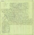
Uintah And Grand Counties 1901 | 1901 | Image/StillImage |
| 188 |
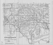 |
Uintah Basin and Adjacent Territory 1914 | 1914 | Image/StillImage |
| 189 |
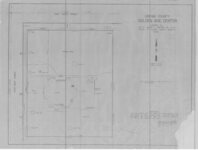 |
Uintah County Golden Age Center Property Plat | 1975 | Image/StillImage |
| 190 |
 |
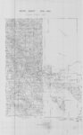
Uintah County R.S. 2477 Road Map | 1880; 1881; 1882; 1883; 1884; 1885; 1886; 1887; 1888; 1889; 1890; 1891; 1892; 1893; 1894; 1895; 1896; 1897; 1898; 1899; 1900; 1901; 1902; 1903; 1904; 1905; 1906; 1907; 1908; 1909; 1910; 1911; 1912; 1913; 1914; 1915; 1916; 1917; 1918; 1919; 1920; 1921; 1922; 1923; 1924; 1925; 1926; 1927; 1928; 1929; ... | Image/StillImage |
| 191 |
 |
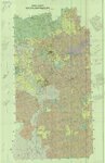
Uintah County School Districts 1900 | 1906; 1907; 1908; 1909; 1910; 1911; 1912; 1913; 1914; 1915; 1916; 1917; 1918; 1919; 1920; 1921; 1922; 1923; 1924; 1925; 1926; 1927; 1928; 1929; 1930; 1931; 1932; 1933; 1934; 1935; 1936; 1937; 1938; 1939; 1940 | Image/StillImage |
| 192 |
 |
Uintah County School, Section 36 | 1898 | Image/StillImage |
| 193 |
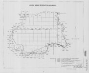 |
Uintah Indian Reservation Boundary | 1875; 1882; 1903; 1949 | Image/StillImage |
| 194 |
 |
Uintah Indian Reserve, Northeast Boundary - Sept. 1875 | 1875 | Image/StillImage |
| 195 |
 |
Uintah Indian Reserve, Utah, North-East Boundary - 1875 | 1875 | Image/StillImage |
| 196 |
 |
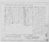
Uintah Railway Elevation Map 1930 | 1930 | Image/StillImage |
| 197 |
 |
Uintah School 1906-1940 | 1906; 1907; 1908; 1909; 1910; 1911; 1912; 1913; 1914; 1915; 1916; 1917; 1918; 1919; 1920; 1921; 1922; 1923; 1924; 1925; 1926; 1927; 1928; 1929; 1930; 1931; 1932; 1933; 1934; 1935; 1936; 1937; 1938; 1939; 1940 | Image/StillImage |
| 198 |
 |
Uintah School District 1 thru 7, 1910-1917 | 1910; 1911; 1912; 1913; 1914; 1915; 1916; 1917 | Image/StillImage |
| 199 |
 |
Uintah School District 12 and 13, 1910-1917 | 1910; 1911; 1912; 1913; 1914; 1915; 1916; 1917 | Image/StillImage |
| 200 |
 |
United States and Texas, Mexico, and Guatemala - 1839 | 1839 | Image/StillImage |