Home
Browse
Ask Us
Chat
Harmful Language Statement
Log in
Theses & Dissertations
Advanced Search
Year
1950
1951
1952
1953
1954
1955
1956
1957
1958
1959
1960
1961
1962
1963
1964
1965
1966
1967
1968
1969
1970
1971
1972
1973
1974
1975
1976
1977
1978
1979
1980
1981
1982
1983
1984
1985
1986
1987
1988
1989
1990
1991
1992
1993
1994
1995
1996
1997
1998
1999
2000
2001
2002
2003
2004
2005
2006
2007
2008
2009
2010
2011
2012
2013
2014
2015
TO
1950
1951
1952
1953
1954
1955
1956
1957
1958
1959
1960
1961
1962
1963
1964
1965
1966
1967
1968
1969
1970
1971
1972
1973
1974
1975
1976
1977
1978
1979
1980
1981
1982
1983
1984
1985
1986
1987
1988
1989
1990
1991
1992
1993
1994
1995
1996
1997
1998
1999
2000
2001
2002
2003
2004
2005
2006
2007
2008
2009
2010
2011
2012
2013
2014
2015
School Or College
College of Mines & Earth Sciences
151
College of Architecture & Planning
10
College of Mines and Earth Sciences
5
College of Social & Behavioral Science
2
College of Fine Arts
1
Department
Geology & Geophysics
134
Materials Science & Engineering
12
Architecture
10
Mining Engineering
10
Geography
2
Film & Media Arts
1
More
Publication Type
thesis
145
map
23
honors thesis
1
Subject
Utah
48
Geology
44
Thesis and dissertation georeferencing project
25
Thesis and dissertation georeferencing project
17
Stratigraphic
13
Geology -- Utah -- Tooele County
9
Geology -- Utah -- Box Elder County
7
Summit County
7
Geology -- Utah -- Summit County
6
Grand County
6
Wasatch County
6
Beaver County
5
Coalville region
5
Basalt -- Utah
4
Geology -- Utah -- Beaver County
4
Geology -- Utah -- Mineral Mountains
4
Sediments (Geology)
4
Tertiary
4
Bonneville
3
Box Elder County
3
Carbon County
3
Cretaceous
3
Crystalline
3
Geology -- Structural -- Utah -- Willard Peak area
3
Geology -- Utah -- Grassy Mountains -- Maps
3
Geology -- Utah -- Juab County
3
Geology -- Utah -- Kane County
3
Geology -- Utah -- Kane County -- Paria Northwest quadrangle
3
Geology -- Utah -- Lakeside Mountains -- Maps
3
Geology -- Utah -- Sheeprock Mountains
3
Geology -- Utah -- Weber County
3
Geology--Utah
3
Granite
3
Great Salt Lake Basin
3
Juab County
3
Landslides -- Utah -- Kane County
3
Mesozoic
3
Metamorphic
3
Millard County
3
Mineral Range (Utah)
3
Mines and mineral resources -- Utah -- Deep Creek Mountains
3
Moenkopi group
3
Mount Ogden
3
Natural gas
3
Newfoundland Mountains
3
Petrology
3
Petrology -- Utah -- Beaver County
3
Petrology -- Utah -- Wasatch Mountains
3
Precambrian
3
Rocks
3
Salt Lake County
3
Silver Island Mountains
3
Stansbury Island
3
Stratigraphic geology
3
Thaynes Formation
3
Uinta Basin (Utah and Colo.)
3
Utah County
3
Wasatch Hinterland
3
Geothermal resources -- Utah
2
Geochemistry
2
Geology -- Uinta Mountains (Utah and Wyo.)
2
Geology -- Utah -- Morgan County
2
Geology -- Utah -- Upton area
2
Geology, Economic -- Utah -- Sulphurdale
2
Geothermal resources -- Utah
2
Lake
2
Mineralogy
2
Mines and mineral resources -- Utah -- Sulphurdale
2
Ore deposits
2
Sulphur mines and mining -- Utah -- Sulphurdale
2
Cedar Mountains
1
Cove Creek area
1
Designs
1
Faults (Geology) -- Nevada -- Lincoln County,Nye County
1
Fine arts
1
Geology -- Utah -- Juab County -- Tintic Mining District
1
Geology -- Utah -- Ogden Valley
1
Geology -- Utah -- Silver Island Mountains
1
Geology: Stratigraphic-Paleozoic
1
Groundwater -- Utah -- Ogden Valley
1
Kenya
1
Lothidok Range
1
Mines and mineral resources-Beaver County
1
Photography
1
Plans
1
Recreation centers
1
Stratigraphic-Mesozoic
1
Structural
1
Thesis and dissertation dereferencing project
1
Tooele County
1
Uinta Mountains
1
Utah-Star Range
1
Volcanism -- Nevada -- Lincoln County, Nye County
1
More
Filters:
Collection:
"ir_etd"
Type:
"Image"
1
-
25
of
169
<
1
2
3
4
5
6
7
>
Gallery view
Number of results to display per page
10
25
50
100
200
Sort by Relevance
Sort by Title A-Z
Sort by Title Z-A
Sort by Date Ascending
Sort by Date Descending
Sort by Last Modified Ascending
Sort by Last Modified Descending
Author
Title
Subject
Date
Publication Type
1
Parr, Clayton Joseph
A study of primary sedimentary structures around the Moab anticline, Grand County, Utah (Google Earth map overlay KMZ file)
Geology; Utah; Grand County
1965-08
map
2
Parr, Clayton Joseph
A study of primary sedimentary structures around the Moab anticline, Grand County, Utah (Thesis and maps)
Geology; Utah; Grand County
1965-08
thesis
3
Parr, Clayton Joseph
A study of primary sedimentary structures around the Moab anticline, Grand County, Utah: Georeferenced map files
Geology; Utah; Grand County
1965-08
thesis
4
Brooke, John Percival
Alteration and trace elements of volcanics in the San Francisco Mountains
Mineralogy; Utah; Beaver County; Geochemistry; Ore deposits; Thesis and dissertation georeferencing project
1964-06
thesis
5
Brooke, John Percival
Alteration and trace elements of volcanics in the San Francisco Mountains (Google Earth map overlay KMZ file)
Mineralogy; Utah; Beaver County; Geochemistry; Ore deposits; Thesis and dissertation georeferencing project
1964-06
map
6
Brooke, John Percival
Alteration and trace elements of volcanics in the San Francisco Mountains: Georeferenced map files
Thesis and dissertation georeferencing project
1964-06
thesis
7
Wood, William James
Areal geology of the Coalville vicinity, Summit County, Utah
Geology; Utah; Coalville region
1953-06
thesis
8
Wood, William James
Areal geology of the Coalville vicinity, Summit County, Utah (Google Earth map overlay KMZ file)
Geology; Utah; Coalville region; Thesis and dissertation georeferencing project
1953-06
map
9
Wood, William James
Areal geology of the Coalville vicinity, Summit County, Utah: Georeferenced map files
Geology; Utah; Coalville region
1953-06
thesis
10
Stark, Norman Paul
Areal geology of the Upton region, Summit County, Utah-Maps
1953-06
thesis
11
Stark, Norman Paul
Areal geology of the Upton Region, Summit County, Utah: Georeferenced map files
Geology -- Utah -- Upton area; Summit County; Coalville region
1953-06
thesis
12
O'Neill, Kelly
Bifurcate: Intersections and Photography
Fine arts; Photography
2015-04
honors thesis
13
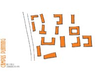
Metcalf, Matt
Campus planning: axes, vistas and organizational views
2011
thesis
14
Mann, Daven Craig
Clastic laramide sediments of the Wasatch Hinterland, Northeastern Utah (Thesis and maps)
Sediments (Geology); Utah; Wasatch Hinterland
1974
thesis
15
Mann, Daven Craig
Clastic laramide sediments of the Wasatch Hinterland, Northeastern Utah: Georeferenced map files
Sediments (Geology); Utah; Wasatch Hinterland
1974
thesis
16
Rodriguez, Enrique Levy
Economic geology of the sulphur deposits at Sulphurdale, Utah-Maps
1960-08
thesis
17
Rodriguez, Enrique Levy
Economic geology of the sulphur deposits at Sulphurdale, Utah: Georeferenced map files
Geology, Economic -- Utah -- Sulphurdale; Mines and mineral resources -- Utah -- Sulphurdale; Sulphur mines and mining -- Utah -- Sulphurdale
1960-08
thesis
18
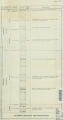
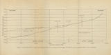
Gates, Joseph S.
Figure 4: Longitudinal profile of Middle Canyon showing locations of the profiles across the canyon, the nickpoint, and the hypothetical profile before rejuvenation
Thesis and dissertation georeferencing project
1960-08
thesis
19
Carter, Eric Jeffery
Final graduate design studio
2011
thesis
20
Arrington, Josh
Final Studio: Princeton University
2011
thesis
21
Baker, Walker Holcombe
Geologic setting and origin of the Grouse Creek pluton, Box Elder County, Utah-Maps
Geology--Utah
1959-06
thesis
22
Baker, Walker Holcombe
Geologic setting and origin of the Grouse Creek pluton, Box Elder County, Utah: Georeferenced map files
Geology--Utah
1959-06
thesis
23
Doyuran, Vedat
Geology and ground-water resources of Ogden Valley, Utah
Geology -- Utah -- Ogden Valley; Groundwater -- Utah -- Ogden Valley; Thesis and dissertation georeferencing project
1972-06
thesis
24
Blue, Donald McCoy
Geology and ore deposits of the Lucin Mining District, Box Elder County, Utah and Elko County, Nevada: Georeferenced map files
1960-08
thesis
25
Blue, Donald McCoy
Geology and ore deposits of the lucin mining district, Box Elder County, Utah, and Elko County, Nevada-Maps
1960-08
thesis
1
-
25
of
169
<
1
2
3
4
5
6
7
>