Home
Browse
Ask Us
Chat
Harmful Language Statement
Log in
Theses & Dissertations
Advanced Search
Year
1950
1951
1952
1953
1954
1955
1956
1957
1958
1959
1960
1961
1962
1963
1964
1965
1966
1967
1968
1969
1970
1971
1972
1973
1974
1975
1976
1977
1978
1979
1980
1981
1982
1983
1984
1985
1986
1987
1988
1989
1990
1991
1992
1993
1994
1995
1996
1997
1998
1999
2000
2001
2002
2003
2004
2005
2006
2007
2008
2009
2010
2011
2012
2013
2014
2015
2016
TO
1950
1951
1952
1953
1954
1955
1956
1957
1958
1959
1960
1961
1962
1963
1964
1965
1966
1967
1968
1969
1970
1971
1972
1973
1974
1975
1976
1977
1978
1979
1980
1981
1982
1983
1984
1985
1986
1987
1988
1989
1990
1991
1992
1993
1994
1995
1996
1997
1998
1999
2000
2001
2002
2003
2004
2005
2006
2007
2008
2009
2010
2011
2012
2013
2014
2015
2016
School Or College
College of Mines & Earth Sciences
7
College of Social & Behavioral Science
1
Department
Geology & Geophysics
7
Geography
1
Publication Type
thesis
6
map
2
Columnar Section
1
online portfolio
1
Subject
Cedar Triangulation Station
1
Fairfield - Utah
1
Geologic cross-sections
1
Geological map
1
Geology - Rozel Hills. Utah
1
Geology -- Utah -- Beaver County
1
Geology -- Utah -- Mineral Mountains
1
Geology map
1
Jordan Narrows - Utah
1
Lark- Utah
1
Magna - Utah
1
Rydalch Pass
1
Thesis and dissertation georeferencing project
1
More
Filters:
Collection:
"ir_etd"
Format:
"image/jpeg"
1
-
25
of
10
Gallery view
Number of results to display per page
10
25
50
100
200
Sort by Relevance
Sort by Title A-Z
Sort by Title Z-A
Sort by Date Ascending
Sort by Date Descending
Sort by Last Modified Ascending
Sort by Last Modified Descending
Author
Title
Subject
Date
Publication Type
1
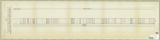
Mourer, Robert E.
Columnar section of the permian unnamed formation exposed between Rydalch Pass and US Coast and geodetic survey Cedar Triangulation Station Plate VIII
Geologic cross-sections; Rydalch Pass; Cedar Triangulation Station
Columnar Section
2
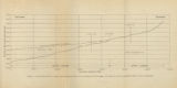
Gates, Joseph S.
Figure 4: Longitudinal profile of Middle Canyon showing locations of the profiles across the canyon, the nickpoint, and the hypothetical profile before rejuvenation
Thesis and dissertation georeferencing project
1960-08
thesis
3
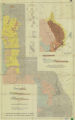
Amin, Surendra R.
Map 1: Geologic map of Antelope intrusive and vicinity
1950
thesis
4
Arnold, Steven
MSGIS Portfolio
2016-12
online portfolio
5
Brox, George Stanley
Plate 1: Geologic map of Northern Bryce Canyon National Park
1961-06
thesis
6
Mount, Donald Lee
Plate 3: Geologic map and sections of Wanship-Park City region, Utah
1952-06
thesis
7
Hooper, Warren G.
Plate 3: Geologic map of portion of Northwestern Uinta Mountains, Utah
1951
thesis
8
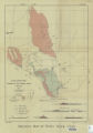
Earll, Fred Nelson
Plate1-part1 Geologic map of the Central Mineral Range, Beaver County, Utah
Geology -- Utah -- Mineral Mountains; Geology -- Utah -- Beaver County
1957-08
thesis
9
Plate17 Geologic map and sections of parts of the Magna, Lark, Fairfield, and Jordan Narrows quadrangles, Utah
Magna - Utah; Lark- Utah; Fairfield - Utah; Jordan Narrows - Utah; Geological map
1955
map
10
Slentz, L. W.
Plate18 Geologic map of Rozel Hills, Utah
Geology - Rozel Hills. Utah; Geology map
1955-06
map
1
-
25
of
10