TO
Filters: Research Institute: "Institute for Clean and Secure Energy (ICSE)" School Or College: "University of Utah" Collection: "ir_eua" Format: image
| Title | Date | Subject | Description | ||
|---|---|---|---|---|---|
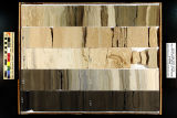
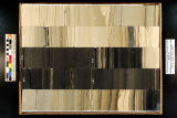
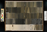
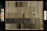
| 1 |
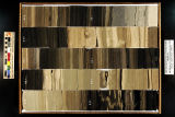
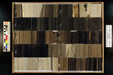 |
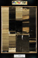
Skyline 16: SW SW sec. 10 11S 25E Uintah County, Utah. Box 77 Depth: 780.0 - 790.0 ft. | 2015-07 | core samples; Skyline 16; box 77; Green River Formation | Core sample photograph by the Utah Geological Survey at the University of Utah, and the Utah Core Research Center. Skyline 16: SW SW sec. 10 11S 25E Uintah County, Utah. Box 77 Depth: 780.0 - 790.0 ft. |
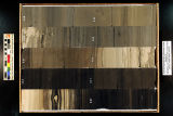
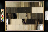
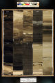
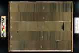
| 2 |
 |
Skyline 16: SW SW sec. 10 11S 25E Uintah County, Utah. Box 98 Depth: 990.0 - 1000.0 ft. | 2015-07 | core sample; Skyline 16; box 98; Green River Formation | Core sample photograph by the Utah Geological Survey at the University of Utah, and the Utah Core Research Center. Skyline 16: SW SW sec. 10 11S 25E Uintah County, Utah. Box 98 Depth: 990.0 - 1000.0 ft. |
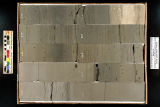
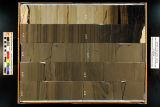
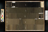
| 3 |
 |
Skyline 16: SW SW sec. 10 11S 25E Uintah County, Utah. Box 82 Depth: 830.0 - 840.0 ft. | 2015-07 | core samples; Skyline 16; box 82; Green River Formation | Core sample photograph by the University of Utah, and the Utah Core Research Center. Skyline 16: SW SW sec. 10 11S 25E Uintah County, Utah. Box 82 Depth: 830.0 - 840.0 ft. |
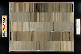
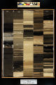
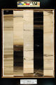
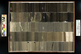
| 4 |
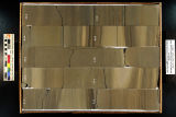 |
Skyline 16: SW SW sec. 10 11S 25E Uintah County, Utah. Box 83 Depth: 840.0 - 850.0 ft. | 2015-07 | core sample; Skyline 16; box 83; Green River Formation | Core sample photograph by the Utah Geological Survey at the University of Utah, and the Utah Core Research Center. Skyline 16: SW SW sec. 10 11S 25E Uintah County, Utah. Box 83 Depth: 840.0 - 850.0 ft. |
| 5 |
 |
Skyline 16: SW SW sec. 10 11S 25E Uintah County, Utah. Box 95 Depth: 960.0 - 970.0 ft. | 2015-07 | core sample; Skyline 16; box 95; Green River Formation | Core sample photograph by the Utah Geological Survey at the University of Utah, and the Utah Core Research Center. Skyline 16: SW SW sec. 10 11S 25E Uintah County, Utah. Box 95 Depth: 960.0 - 970.0 ft. |
| 6 |
 |
Skyline 16: SW SW sec. 10 11S 25E Uintah County, Utah. Box 73 Depth: 740.0 - 750.0 ft. | 2015-07 | core samples; Skyline 16; box 73; Green River Formation | Core sample photograph by the Utah Geological Survey at the University of Utah, and the Utah Core Research Center. Skyline 16: SW SW sec. 10 11S 25E Uintah County, Utah. Box 73 Depth: 740.0 - 750.0 ft. |
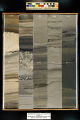
| 7 |
 |
Skyline 16: SW SW sec. 10 11S 25E Uintah County, Utah. Box 80 Depth: 810.0 - 820.0 ft. | 2015-07 | core samples; Skyline 16; box 80; Green River Formation | Core sample photograph by the Utah Geological Survey at the University of Utah, and the Utah Core Research Center. Skyline 16: SW SW sec. 10 11S 25E Uintah County, Utah. Box 80 Depth: 810.0 - 820.0 ft. |
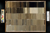
| 8 |
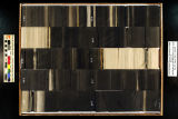 |
Skyline 16: SW SW sec. 10 11S 25E Uintah County, Utah. Box 79 Depth: 800.0 - 810.0 ft. | 2015-07 | core samples; Skyline 16; box 79; Green River Formation | Core sample photograph by the Utah Geological Survey at the University of Utah, and the Utah Core Research Center. Skyline 16: SW SW sec. 10 11S 25E Uintah County, Utah. Box 79 Depth: 800.0 - 810.0 ft. |
| 9 |
 |
Skyline 16: SW SW sec. 10 11S 25E Uintah County, Utah. Box 92 Depth: 930.0 - 940.0 ft. | 2015-07 | core sample; Skyline 16; box 92; Green River Formation | Core sample photograph by the Utah Geological Survey at the University of Utah, and the Utah Core Research Center. Skyline 16: SW SW sec. 10 11S 25E Uintah County, Utah. Box 92 Depth: 930.0 - 940.0 ft. |
| 10 |
 |
Skyline 16: SW SW sec. 10 11S 25E Uintah County, Utah. Box 87 Depth: 880.0 - 890.0 ft. | 2015-07 | core sample; Skyline 16; box 87; Green River Formation | Core sample photograph by the Utah Geological Survey at the University of Utah, and the Utah Core Research Center. Skyline 16: SW SW sec. 10 11S 25E Uintah County, Utah. Box 87 Depth: 880.0 - 890.0 ft. |
| 11 |
 |
Skyline 16: SW SW sec. 10 11S 25E Uintah County, Utah. Box 86 Depth: 870.0 - 880.0 ft. | 2015-07 | core sample; Skyline 16; box 86; Green River Formation | Core sample photograph by the Utah Geological Survey at the University of Utah, and the Utah Core Research Center. Skyline 16: SW SW sec. 10 11S 25E Uintah County, Utah. Box 86 Depth: 870.0 - 880.0 ft. |
| 12 |
 |
Skyline 16: SW SW sec. 10 11S 25E Uintah County, Utah. Box 88 Depth: 890.0 - 900.0 ft. | 2015-07 | core sample; Skyline 16; box 88; Green River Formation | Core sample photograph by the Utah Geological Survey at the University of Utah, and the Utah Core Research Center. Skyline 16: SW SW sec. 10 11S 25E Uintah County, Utah. Box 88 Depth: 890.0 - 900.0 ft. |
| 13 |
 |
Skyline 16: SW SW sec. 10 11S 25E Uintah County, Utah. Box 78 Depth: 790.0 - 800.0 ft. | 2015-07 | core samples; Skyline 16; box 78; Green River Formation | Core sample photograph by the Utah Geological Survey at the University of Utah, and the Utah Core Research Center. Skyline 16: SW SW sec. 10 11S 25E Uintah County, Utah. Box 78 Depth: 790.0 - 800.0 ft. |
| 14 |
 |
Skyline 16: SW SW sec. 10 11S 25E Uintah County, Utah. Box 81 Depth: 820.0 - 830.0 ft. | 2015-07 | core samples; Skyline 16; box 81; Green River Formation | Core sample photograph by the University of Utah, and the Utah Core Research Center. Skyline 16: SW SW sec. 10 11S 25E Uintah County, Utah. Box 81 Depth: 820.0 - 830.0 ft. |
| 15 |
 |
Skyline 16: SW SW sec. 10 11S 25E Uintah County, Utah. Box 96 Depth: 970.0 - 980.0 ft. | 2015-07 | core sample; Skyline 16; box 96; Green River Formation | Core sample photograph by the Utah Geological Survey at the University of Utah, and the Utah Core Research Center. Skyline 16: SW SW sec. 10 11S 25E Uintah County, Utah. Box 96 Depth: 970.0 - 980.0 ft. |
| 16 |
 |
Skyline 16: SW SW sec. 10 11S 25E Uintah County, Utah. Box 76 Depth: 770.0 - 780.0 ft. | 2015-07 | core samples; Skyline 16; box 76; Green River Formation | Core sample photograph by the Utah Geological Survey at the University of Utah, and the Utah Core Research Center. Skyline 16: SW SW sec. 10 11S 25E Uintah County, Utah. Box 76 Depth: 770.0 - 780.0 ft. |
| 17 |
 |
Skyline 16: SW SW sec. 10 11S 25E Uintah County, Utah. Box 93 Depth: 940.0 - 950.0 ft. | 2015-07 | core sample; Skyline 16; box 93; Green River Formation | Core sample photograph by the Utah Geological Survey at the University of Utah, and the Utah Core Research Center. Skyline 16: SW SW sec. 10 11S 25E Uintah County, Utah. Box 93 Depth: 940.0 - 950.0 ft. |
| 18 |
 |
Skyline 16: SW SW sec. 10 11S 25E Uintah County, Utah. Box 85 Depth: 860.0 - 870.0 ft. | 2015-07 | core sample; Skyline 16; box 85; Green River Formation | Core sample photograph by the Utah Geological Survey at the University of Utah, and the Utah Core Research Center. Skyline 16: SW SW sec. 10 11S 25E Uintah County, Utah. Box 85 Depth: 860.0 - 870.0 ft. |
| 19 |
 |
Skyline 16: SW SW sec. 10 11S 25E Uintah County, Utah. Box 91 Depth: 920.0 - 930.0 ft. | 2015-07 | core sample; Skyline 16; box 91; Green River Formation | Core sample photograph by the Utah Geological Survey at the University of Utah, and the Utah Core Research Center. Skyline 16: SW SW sec. 10 11S 25E Uintah County, Utah. Box 91 Depth: 920.0 - 930.0 ft. |
| 20 |
 |
Skyline 16: SW SW sec. 10 11S 25E Uintah County, Utah. Box 94 Depth: 950.0 - 960.0 ft. | 2015-07 | core sample; Skyline 16; box 94; Green River Formation | Core sample photograph by the Utah Geological Survey at the University of Utah, and the Utah Core Research Center. Skyline 16: SW SW sec. 10 11S 25E Uintah County, Utah. Box 94 Depth: 950.0 - 960.0 ft. |
| 21 |
 |
Skyline 16: SW SW sec. 10 11S 25E Uintah County, Utah. Box 89 Depth: 900.0 - 910.0 ft. | 2015-07 | core sample; Skyline 16; box 89; Green River Formation | Core sample photograph by the Utah Geological Survey at the University of Utah, and the Utah Core Research Center. Skyline 16: SW SW sec. 10 11S 25E Uintah County, Utah. Box 89 Depth: 900.0 - 910.0 ft. |
| 22 |
 |
Skyline 16: SW SW sec. 10 11S 25E Uintah County, Utah. Box 84 Depth: 850.0 - 860.0 ft. | 2015-07 | core sample; Skyline 16; box 84; Green River Formation | Core sample photograph by the Utah Geological Survey at the University of Utah, and the Utah Core Research Center. Skyline 16: SW SW sec. 10 11S 25E Uintah County, Utah. Box 84 Depth: 850.0 - 860.0 ft. |
| 23 |
 |
Skyline 16: SW SW sec. 10 11S 25E Uintah County, Utah. Box 99 Depth: 1000.0 - 1006.25 ft. | 2015-07 | core sample; Skyline 16; Green River Formation; box 99 | Core sample photograph by the Utah Geological Survey at the University of Utah, and the Utah Core Research Center. Skyline 16: SW SW sec. 10 11S 25E Uintah County, Utah. Box 99 Depth: 1000.0 - 1006.25 ft. |
| 24 |
 |
Skyline 16: SW SW sec. 10 11S 25E Uintah County, Utah. Box 74 Depth: 750.0 - 760.0 ft. | 2015-07 | core samples; Skyline 16; box 74; Green River Formation | Core sample photograph by the Utah Geological Survey at the University of Utah, and the Utah Core Research Center. Skyline 16: SW SW sec. 10 11S 25E Uintah County, Utah. Box 74 Depth: 750.0 - 760.0 ft. |
| 25 |
 |
Skyline 16: SW SW sec. 10 11S 25E Uintah County, Utah. Box 75 Depth: 760.0 - 770.0 ft. | 2015-07 | core samples; Skyline 16; box 75; Green River Formation | Core sample photograph by the Utah Geological Survey at the University of Utah, and the Utah Core Research Center. Skyline 16: SW SW sec. 10 11S 25E Uintah County, Utah. Box 75 Depth: 760.0 - 770.0 ft. |