Home
Browse
Ask Us
Chat
Harmful Language Statement
Log in
Advanced Search
Year
1894
1895
1896
1897
1898
1899
1900
1901
1902
1903
1904
1905
1906
1907
1908
1909
1910
1911
1912
1913
1914
1915
1916
1917
1918
1919
1920
1921
1922
1923
1924
1925
1926
1927
1928
1929
1930
1931
1932
1933
1934
1935
1936
1937
1938
1939
1940
1941
1942
1943
1944
1945
1946
1947
1948
1949
1950
1951
1952
1953
1954
1955
1956
1957
1958
1959
1960
1961
1962
1963
1964
1965
1966
1967
1968
1969
1970
1971
1972
1973
1974
1975
1976
1977
1978
1979
1980
1981
1982
1983
1984
1985
1986
1987
1988
1989
1990
1991
1992
1993
1994
1995
1996
1997
1998
1999
2000
2001
2002
2003
2004
2005
2006
2007
2008
2009
2010
2011
2012
2013
2014
2015
2016
2017
2018
2019
2020
TO
1894
1895
1896
1897
1898
1899
1900
1901
1902
1903
1904
1905
1906
1907
1908
1909
1910
1911
1912
1913
1914
1915
1916
1917
1918
1919
1920
1921
1922
1923
1924
1925
1926
1927
1928
1929
1930
1931
1932
1933
1934
1935
1936
1937
1938
1939
1940
1941
1942
1943
1944
1945
1946
1947
1948
1949
1950
1951
1952
1953
1954
1955
1956
1957
1958
1959
1960
1961
1962
1963
1964
1965
1966
1967
1968
1969
1970
1971
1972
1973
1974
1975
1976
1977
1978
1979
1980
1981
1982
1983
1984
1985
1986
1987
1988
1989
1990
1991
1992
1993
1994
1995
1996
1997
1998
1999
2000
2001
2002
2003
2004
2005
2006
2007
2008
2009
2010
2011
2012
2013
2014
2015
2016
2017
2018
2019
2020
Type
Image
45
Text
13
Format
application/pdf
45
Collection
Civilian Conservation Corps
6
Elias Hicks Blackburn Papers, 1848-1908
1
Peoples of Utah Revisited
2
Photo Archives
25
Sustainability U
1
Theses & Dissertations
2
Westminster University Institutional ...
8
More
Filters:
Format:
"application/pdf"
Type:
"Image"
1
-
25
of
45
<
1
2
>
Gallery view
Number of results to display per page
10
25
50
100
200
Sort by Relevance
Sort by Title A-Z
Sort by Title Z-A
Sort by Date Ascending
Sort by Date Descending
Sort by Last Modified Ascending
Sort by Last Modified Descending
Title
Date
Type
Setname
1
"Peter's Sugar Farm" (Farming) Chapter 5 Illustration, before page 25: Bill [Wilson] dipped the siphon into the ditch, filling it with water. When he laid this over the brink of the ditch, with one end in the furrow and one in the water, it acted as a siphon and kept drawing water from the main ditch.
1945; 1946; 1947; 1948
Image
uum_map
2
"Peter's Sugar Farm" (Farming) Chapter 4 Illustration, before page 25: Down the rows went Bill [Wilson] and Mr. [Robert] Brown, keeping the water moving along the furrows.
1945; 1946; 1947; 1948
Image
uum_map
3
"Peter's Sugar Farm" (Farming) Chapter 4 Illustration, before page 25: The water must be kept moving down the furrows, so the plants won't be flooded out.
1945; 1946; 1947; 1948
Image
uum_map
4
"Peter's Sugar Farm" (Farming) Chapter 4 Illustration, before page 23: Mr. Jensen irrigated in the old-fashioned way, by running the water from the head stream down through the furrows of the field.
1945; 1946; 1947; 1948
Image
uum_map
5
"Peter's Sugar Farm" (Farming) Chapter 4 Illustration, before page 25: [Robert Brown,] Peter's father removed the headgate, and the water ran into their ditch.
1945; 1946; 1947; 1948
Image
uum_map
6
"Peter's Sugar Farm" (Farming) Chapter 4 Illustration, before page 25: The head stream was lined with cement in order to prevent the wasting of water by seepage through the soil.
1945; 1946; 1947; 1948
Image
uum_map
7
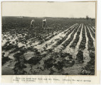
Farm empire, Salt River Valley, Arizona
1945; 1946; 1947; 1948; 1949; 1950; 1951; 1952; 1953; 1954; 1955
Image
uum_map
8
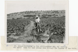
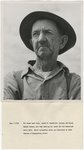
Oscar N. Trueblood, Idaho farmer
1948; 1949; 1950; 1951; 1952; 1953; 1954; 1955
Image
uum_map
9
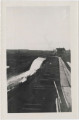
Malad development penstock and pressure box
1911; 1912; 1913; 1914; 1915
Image
uum_map
10
Malad Power Flume spillway near pressure box
1909; 1910; 1911; 1912; 1913; 1914; 1915
Image
uum_map
11
Malad Power Pipeline across Malad River
1914-02-08
Image
uum_map
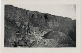
12
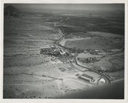
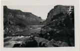
Malad Power Station, Malad Gorge, Gooding County, Idaho
1911; 1912; 1913; 1914; 1915
Image
uum_map
13
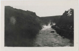
Steam rising from Malad River
1911; 1912; 1913; 1914; 1915
Image
uum_map
14
Framing Malad River intake gates
1909; 1910; 1911; 1912; 1913; 1914; 1915
Image
uum_map
15
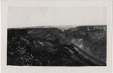
Intake Malad Power flume looking down Malad River
1914-02-08
Image
uum_map
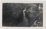
16
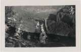
Looking down on Malad River and flume from south side of canyon
1909; 1910; 1911; 1912; 1913; 1914; 1915
Image
uum_map
17
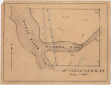
Lot 1, sec. 34, T.6S., R. 13E.
1911; 1912; 1913; 1914; 1915
Image
uum_map
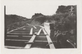
18
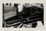
Malad Power Flume during construction
1909; 1910; 1911; 1912; 1913; 1914; 1915
Image
uum_map
19
Malad Power Flume during construction
1909; 1910; 1911; 1912; 1913; 1914; 1915
Image
uum_map
20
Malad Power Flume during construction
1909; 1910; 1911; 1912; 1913; 1914; 1915
Image
uum_map
21
Malad Power Intake flume looking up Malad River
1914-02-08
Image
uum_map
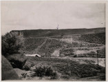
22
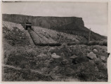
Malad Power Plant machinery came down this road. Tractor used to haul from Shoshone. Tractor near center of photo.
1911; 1912; 1913; 1914; 1915
Image
uum_map
23
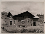
Malad Power Station (Malad Powerhouse), view from south side of Malad River, Gooding County, Idaho
1911; 1912; 1913; 1914; 1915
Image
uum_map
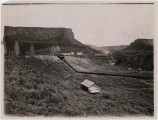
24
Malad River development, (overflow is opposite house)
1911; 1912; 1913; 1914; 1915
Image
uum_map
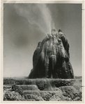
25
Nevada's fountain of youth, Washoe County
1950; 1951; 1952; 1953; 1954; 1955; 1956; 1957; 1958; 1959; 1960; 1961; 1962; 1963; 1964
Image
uum_map
1
-
25
of
45
<
1
2
>