Home
Browse
Ask Us
Chat
Harmful Language Statement
Log in
Institutional Repository
Advanced Search
Year
1905
1906
1907
1908
1909
1910
1911
1912
1913
1914
1915
1916
1917
1918
1919
1920
1921
1922
1923
1924
1925
1926
1927
1928
1929
1930
1931
1932
1933
1934
1935
1936
1937
1938
1939
1940
1941
1942
1943
1944
1945
1946
1947
1948
1949
1950
1951
1952
1953
1954
1955
1956
1957
1958
1959
1960
1961
1962
1963
1964
1965
1966
1967
1968
1969
1970
1971
1972
1973
1974
1975
1976
1977
1978
1979
1980
1981
1982
1983
1984
1985
1986
1987
1988
1989
1990
1991
1992
1993
1994
1995
1996
1997
1998
1999
2000
2001
2002
2003
2004
2005
2006
2007
2008
2009
2010
2011
2012
2013
2014
2015
2016
2017
2018
2019
2020
2021
2022
2023
2024
TO
1905
1906
1907
1908
1909
1910
1911
1912
1913
1914
1915
1916
1917
1918
1919
1920
1921
1922
1923
1924
1925
1926
1927
1928
1929
1930
1931
1932
1933
1934
1935
1936
1937
1938
1939
1940
1941
1942
1943
1944
1945
1946
1947
1948
1949
1950
1951
1952
1953
1954
1955
1956
1957
1958
1959
1960
1961
1962
1963
1964
1965
1966
1967
1968
1969
1970
1971
1972
1973
1974
1975
1976
1977
1978
1979
1980
1981
1982
1983
1984
1985
1986
1987
1988
1989
1990
1991
1992
1993
1994
1995
1996
1997
1998
1999
2000
2001
2002
2003
2004
2005
2006
2007
2008
2009
2010
2011
2012
2013
2014
2015
2016
2017
2018
2019
2020
2021
2022
2023
2024
Type
Text
217
Image
134
Format
application/pdf
243
application/vnd.google-earth.kmz
34
application/zip
34
image/jpeg
6
Collection
Honors Theses Closed Archive
1
Theses & Dissertations
236
UScholar Works
80
Filters:
Department:
"Geology & Geophysics"
Year End:
2006
276
-
300
of
317
<
4
5
6
7
8
9
10
11
12
13
>
Gallery view
Number of results to display per page
10
25
50
100
200
Sort by Relevance
Sort by Title A-Z
Sort by Title Z-A
Sort by Date Ascending
Sort by Date Descending
Sort by Last Modified Ascending
Sort by Last Modified Descending
Title
Date
Type
Setname
276
Some early pleistocene deposits of the lower Omo valley: the Usno formation
1969
Text
ir_uspace
277
Stratigraphic analysis of the Mesaverde Group, Uinta Basin, Utah
1961-05
Text; Image
ir_etd
278
Stratigraphic analysis of the Mesaverde Group, Uinta Basin, Utah (Google Earth map overlay KMZ file)
1961-05
Image
ir_etd
279
Stratigraphic analysis of the Mesaverde Group, Uinta Basin, Utah: Georeferenced map files
1961-05
Image
ir_etd
280
Stratigraphy and Depositional Environments of the Toroweap and Kaibab Formations, Southwestern Utah
1981
Text
ir_etd
281
Stratigraphy and depositional environments of the Toroweap and Kaibab Formations, Southwestern Utah, vol. 1
1981
ir_etd
282
Stratigraphy and depositional environments of the Toroweap and Kaibab Formations, Southwestern Utah, vol. 2
1981
ir_etd
283
Stratigraphy and paleoenvironments of the Koobi Fora Formation of the Ileret Area, Northern Kenya
2003-08
Text
ir_etd
284
Stratigraphy and sedimentology of the tidwell member, upper jurassic morrison formation, East-Central Utah
2003
Text
ir_etd
285
Stratigraphy of the Currant Creek Formation, Wasatch and Duchesne Counties, Utah
1967-08
Text
ir_etd
286
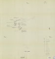
Stratigraphy of the Star Range and reconnaissance study of three selected mines
1969-06
Text
ir_etd
287
Stratigraphy of the Star Range and reconnaissance study of three selected mines-Maps
1969-06
Image
ir_etd
288
Structural evolution of the Uinta Mountains, Utah, and their Interaction with the Utah-Wyoming salient of the Sevier Overthrust Belt
1988-06
Text
ir_etd
289
Structural evolution of the Uinta Mountains, Utah, and their interaction with the Utah-Wyoming salient of the sevier overthrust belt
1988
Text
ir_etd
290
Structural geology of the Willard Peak area, North-Central Wasatch Mountains, Utah
1972-12
Text
ir_etd
291
Structural geology of the Willard Peak Area, North-Central Wasatch Mountains, Utah-Maps
1972-12
Image
ir_etd
292
Structural geology of the Willard Peak Area, North-Central Wasatch Mountains, Utah: Georeferenced map files
1972-12
Image
ir_etd
293
Structure and petrology of the diorite on the 800 level Mayflower Mine, Park City, Utah
1953
Text
ir_etd
294
Structure of an earthquake rupture segment boundary in the Lost River fault zone, Idaho : implications for rupture propagation during the 1983 Borah Peak Earthquake
1987
Text
ir_etd
295
Study of the primary decomposition of coal by infrared spectrophotometry and by chloroform extraction
1957-08
Text
ir_etd
296
Subsurface geology of the Mesozoic formations overlying the Uncompahgre Uplift in Grand County, Utah
1961-06
Text; Image
ir_etd
297
Subsurface geology of the Mesozoic formations overlying the Uncompahgre Uplift in Grand County, Utah (Google Earth map overlay KMZ file)
1961-06
Image
ir_etd
298
Subsurface geology of the Mesozoic formations overlying the Uncompahgre Uplift in Grand County, Utah: Georeferenced map files
1961-06
Image
ir_etd
299
Subsurface stratigraphy of the Wasatch Formation of the Uinta Basin, Utah
1963-05
Text
ir_etd
300
Subsurface stratigraphy of the Wasatch Formation of the Uinta Basin, Utah: Georeferenced map files
1963-05
Image
ir_etd
276
-
300
of
317
<
4
5
6
7
8
9
10
11
12
13
>