|
|
Title | Collection Number And Name | Photo Number |
| 1 |
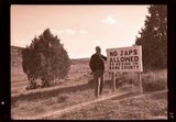 |
"No Japs allowed" sign, 1943 | P0013 Herbert E. Gregory Photograph Collection | P0013n15_11_11_neg |
| 2 |
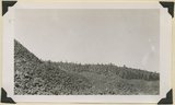
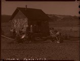 |
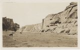
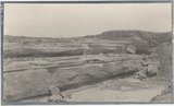
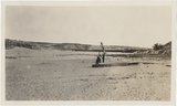
Paria Valley camp, 1943 | P0013 Herbert E. Gregory Photograph Collection | P0013n15_11_04_neg |
| 3 |
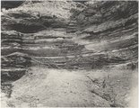 |
Gypsum seams near Holbrook E.C.Case, photo. (Moencopie) | P0013 Herbert E. Gregory Photograph Collection | P0013n06_068_0963 |
| 4 |
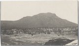 |
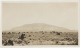
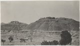
Baigaiche Mt. from "Beast" dike (Photo G388) | P0013 Herbert E. Gregory Photograph Collection | P0013n06_057_0941 |
| 5 |
 |
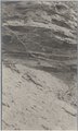
Canyon de Chelly. Cross-bedding (III-9 just like this) (Photo G374) | P0013 Herbert E. Gregory Photograph Collection | P0013n06_049_0925 |
| 6 |
 |
Canyon de Chelly. Shinarump capping Permian (Photo G373) | P0013 Herbert E. Gregory Photograph Collection | P0013n06_048_0924 |
| 7 |
 |
Distant (10 mi.) view of Navaho Mt., southeast (Photo G368) | P0013 Herbert E. Gregory Photograph Collection | P0013n06_045_0917 |
| 8 |
 |
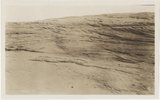
Dunes filling Reservoir Canyon, Tuba (IV-8 in film book is also like this) (Photo G441) | P0013 Herbert E. Gregory Photograph Collection | P0013n06_093_1014 |
| 9 |
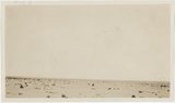 |
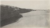
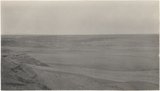
Flat between Little Colorado and Dolores cliff, Tolchaco. "Lake" shown is mirage (Photo G411) | P0013 Herbert E. Gregory Photograph Collection | P0013n06_075_0976 |
| 10 |
 |
Grand Falls, Little Colorado (Photo N-M175) | P0013 Herbert E. Gregory Photograph Collection | P0013n06_079_0986 |
| 11 |
 |
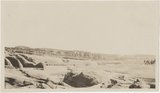
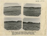
Grand Falls, panorama (Photos G415) | P0013 Herbert E. Gregory Photograph Collection | P0013n06_078a_0982 |
| 12 |
 |
Grand Falls, panorama (Photos G416) | P0013 Herbert E. Gregory Photograph Collection | P0013n06_078a_0983 |
| 13 |
 |
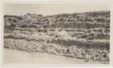
Gypsum in Permian. 2± mi. east of Holbrook (Photo G402) | P0013 Herbert E. Gregory Photograph Collection | P0013n06_067_0961 |
| 14 |
 |
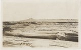
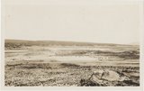
Peneplain; looking southeast from cliffs 5± mi. N 80 deg E, Black Falls (Photo N-M176 and G423) | P0013 Herbert E. Gregory Photograph Collection | P0013n06_081_0990 |
| 15 |
 |
View from "Beast" dike north across Red Lake (Photo G391) | P0013 Herbert E. Gregory Photograph Collection | P0013n06_060_0946 |
| 16 |
 |
View looking northeast up Black Creek from "Beast" dike (Photo G392) | P0013 Herbert E. Gregory Photograph Collection | P0013n06_060_0947 |
| 17 |
 |
Waterhole in desert 1± mi. below Sunrise Spgs. (Photo G395) | P0013 Herbert E. Gregory Photograph Collection | P0013n06_062_0950 |
| 18 |
 |
Wind carving Kaibab 2 mi. above Tolchaco (Photo G414) | P0013 Herbert E. Gregory Photograph Collection | P0013n06_077_0980 |
| 19 |
 |
Wind erosion, La Plata, Tuba (Photo G435) | P0013 Herbert E. Gregory Photograph Collection | P0013n06_088_1005 |
| 20 |
 |
Dolores Badlands 1 1/2 mile west of Nashlini. (I-5 & I-7 in film book just like this) (Photo N-M135) | P0013 Herbert E. Gregory Photograph Collection | P0013n06_003_0827 |
| 21 |
 |
Same as 627 (LaPlata cross-bedding, Totocong, Photo G332) | P0013 Herbert E. Gregory Photograph Collection | P0013n06_025_0874 |
| 22 |
 |
Totocong Spg., Chinlee valley, below Tsenakahn. LaPlata cross-bedding (Photo G331) | P0013 Herbert E. Gregory Photograph Collection | P0013n06_025_0873 |
| 23 |
 |
(Panorama A, B, C, D) Blue Springs Meadows. A stream leading south (left) to Mammoth Creek blocked by basalts from Miller Knoll (right sky line) became a lake that eventuallly cut an outlet through the Brian Head formation (upper left). | P0013 Herbert E. Gregory Photograph Collection | P0013n12_068-069_2929ABCD |
| 24 |
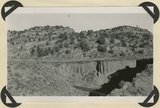 |
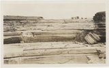
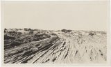
Alluvium valley fill trenched by stream since 1900. Lower Flood Canyon. Kane County, UT. 1943 | P0013 Herbert E. Gregory Photograph Collection | P0013n12_028_2878 |
| 25 |
 |
Basalt, head of Rock Creek. Old lava (foreground) and end of newer flow (center). Garfield County, UT, 1944 | P0013 Herbert E. Gregory Photograph Collection | P0013n12_077_2941 |