Home
Browse
Ask Us
Chat
Harmful Language Statement
Log in
Photo Archives
Advanced Search
About
Over 70,000 photos covering a variety of topics from Marriott Library Special Collections
Year
1910
1911
1912
1913
1914
1915
1916
1917
1918
1919
1920
1921
1922
1923
1924
1925
1926
1927
1928
1929
1930
1931
1932
1933
1934
1935
1936
1937
1938
1939
1940
1941
1942
1943
1944
TO
1910
1911
1912
1913
1914
1915
1916
1917
1918
1919
1920
1921
1922
1923
1924
1925
1926
1927
1928
1929
1930
1931
1932
1933
1934
1935
1936
1937
1938
1939
1940
1941
1942
1943
1944
Type
Image
25
Format
image/jpeg
21
application/pdf
4
Collection Name
Herbert E. Gregory
25
Filters:
Collection Name:
"Herbert E. Gregory"
Collection:
"uum_map"
1
-
25
of
25
Gallery view
Number of results to display per page
10
25
50
100
200
Sort by Relevance
Sort by Title A-Z
Sort by Title Z-A
Sort by Date Ascending
Sort by Date Descending
Sort by Last Modified Ascending
Sort by Last Modified Descending
Sort by Photo Number
Title
Collection Number And Name
Photo Number
1
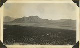
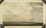
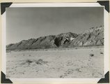
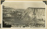
Looking across Big Plains toward Smithsonian Butte (middle background), West Temple (upper right). Foreground forested east slope of Little Creek Mountain, Shinarump; middle distance, dry farm lands on Chinle strata. Washington County, Utah, 1937.
P0013 Herbert E. Gregory Photograph Collection
P0013n10_173_2390
2
Looking southward across House Rock Valley from West Clark Bench. West dipping Navajo sandstone trenched by Kaibab Creek (middle distance) is a part of the East Kaibab monocline; east dipping limestones (skyline) are the cap rocks of the Kaibab upwarp. Kane County, UT, 1944
P0013 Herbert E. Gregory Photograph Collection
P0013n12_035_2882
3
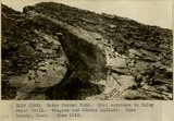
Water Pocket Fold. East entrance to Muley Twist Trail. Wingate and Middle LaPlata. Kane County, UT. June 1918
P0013 Herbert E. Gregory Photograph Collection
P0013n08_080_1457
4
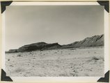
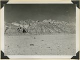
Looking east across Sevier River near Hatch River terraces in middle distance, "Pink Cliffs" (Wasatch) in background bounded by Sevier fault. Garfield County, Utah, 1936.
P0013 Herbert E. Gregory Photograph Collection
P0013n10_147_2341
5
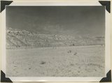
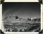
Looking northwest across Parunuweap east of Mt. Carmel, Cretaceous in middle ground, Pink Cliffs in distance, 1936.
P0013 Herbert E. Gregory Photograph Collection
P0013n10_150_2345
6
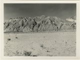
Moenkopi formation: Shnabkaib member (lower part), upper red sandstone (upper middle), Shinarump conglomerate (top). East side of Seamans Wash, Kane County, UT. 1943
P0013 Herbert E. Gregory Photograph Collection
P0013n12_027_2877D
7
Keet Seel, cliff ruins east middle branch of Sagy (Towanaoche) canyon, Ariz., 1910 (Photo G165)
P0013 Herbert E. Gregory Photograph Collection
P0013n04_37_0574
8
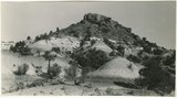
Section of the Shinarump Cliffs (middle distance), east of Pioneer Gap. Shinarump conglomerate exposed by erosion of Moenkopi formation below and the basal strata of the Chinle formation above. Upper Chinle sandstones form Vermilion Cliffs (background).
P0013 Herbert E. Gregory Photograph Collection
P0013n12_052B
9
View looking east across Parunuweap Valley near Mt. Carmel. Distance Elkheart Cliffs (Navajo capped by Carmel) on upthrown side of Sevier fault; middle distance erosion surface in Carmel and other Jurassic. Kane County, Utah, 1932.
P0013 Herbert E. Gregory Photograph Collection
P0013n10_116_2283
10
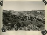
Looking down Notch Canyon from East Point, Elk Ridge, toward Chimney Park. Cottonwood Canyon in middle distance. Buttes of Navajo beyond Shay Mountains in distance. San Juan County, UT, 1928
P0013 Herbert E. Gregory Photograph Collection
P0013n09_125_1964
11
Looking down Notch Canyon from East Point, Elk Ridge, toward Chimney Park. Cottonwood Canyon in middle distance. Buttes of Navajo beyond Shay Mountains in distance. San Juan County, UT, 1928
P0013 Herbert E. Gregory Photograph Collection
P0013n09_125_1964
12
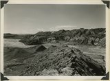
Panorama {a}. Flank of East Kaibab monocline, bordering alluvial floor of Paria Valley. Navajo sandstone (middle sky line), Upper Jurassic strata, and basal Cretaceous (left). Dips of 40 degrees decrease to 3 degrees within 1,000 feet. Kane County, UT, 1944
P0013 Herbert E. Gregory Photograph Collection
P0013n12_042_2889
13
Panorama {b}. Flank of East Kaibab monocline, bordering alluvial floor of Paria Valley. Navajo sandstone (middle sky line), Upper Jurassic strata, and basal Cretaceous (left). Dips of 40 degrees decrease to 3 degrees within 1,000 feet. Kane County, UT, 1944
P0013 Herbert E. Gregory Photograph Collection
P0013n12_042_2890
14
Panorama {c}. Flank of East Kaibab monocline, bordering alluvial floor of Paria Valley. Navajo sandstone (middle sky line), Upper Jurassic strata, and basal Cretaceous (left). Dips of 40 degrees decrease to 3 degrees within 1,000 feet. Kane County, UT, 1944
P0013 Herbert E. Gregory Photograph Collection
P0013n12_042_2891
15
Panorama {d}. Flank of East Kaibab monocline, bordering alluvial floor of Paria Valley. Navajo sandstone (middle sky line), Upper Jurassic strata, and basal Cretaceous (left). Dips of 40 degrees decrease to 3 degrees within 1,000 feet. Kane County, UT, 1944
P0013 Herbert E. Gregory Photograph Collection
P0013n12_043_2892
16
View looking northeast across Kolob Terrace. Basalt (foreground), Cretaceous trenched by Crystal Creek (middle), Pink Cliffs-Wasatch (skyline), lower east slope of Black Mountain (extreme left), 'The Gap,' twin peaks (right skyline), stands just south of Navajo Lake. Iron County, UT, 1942
P0013 Herbert E. Gregory Photograph Collection
P0013n11_188_2827
17
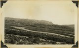
Looking west across Panguitch. Sevier River formation (foreground), alluvium (middle distance), basalt (left center), and pyroclastic slopes leading to Little Creek Peak (background), on the east wall of Bear Valley. Garfield County, UT, 1944
P0013 Herbert E. Gregory Photograph Collection
P0013n12_065_2923
18
Panorama {c}. Flank of East Kaibab monocline, bordering alluvial floor of Paria Valley. Navajo sandstone (middle sky line), Upper Jurassic strata, and basal Cretaceous (left). Dips of 40 degrees decrease to 3 degrees within 1,000 feet. Kane County, UT, 1944
P0013 Herbert E. Gregory Photograph Collection
P0013n12_042_2891
19
Panorama {e}. Flank of East Kaibab monocline, bordering alluvial floor of Paria Valley. Navajo sandstone (middle sky line), Upper Jurassic strata, and basal Cretaceous (left). Dips of 40 degrees decrease to 3 degrees within 1,000 feet. Kane County, UT, 1944
P0013 Herbert E. Gregory Photograph Collection
P0013n12_043_2893
20
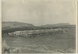
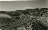
View looking east across north end of No Man's Mesa, composed of Navajo sandstone partly capped by Carmel limestone. Park Wash (foreground) area drained by Kitchen Canyon tributary to Paria River (middle background). Panoramic with no. 887. Kane County, UT, 1940
P0013 Herbert E. Gregory Photograph Collection
P0013n11_109_2700
21
Zion Park Cliffs, from Shinarump bench, near base of Smithsonian Butte. Virgin River in middle distance; West Temple center distance; at the right Bridge Mountain, East Temple, The Twin Brothers, and Mountain of the Sun. Zion National Park, Utah, 1936.
P0013 Herbert E. Gregory Photograph Collection
P0013n10_205_2458
22
Looking south along Paria River from the mouth of Shurtz Gorge. Navajo sandstone in East Kaibab monocline is overlaid with decreasing dips by Upper Jurassic (banked against the Navajo), Dakota, and Tropic (foreground and left sky line). Erosion surface (middle distance) bevels upturned rocks. Kane County, UT, 1944
P0013 Herbert E. Gregory Photograph Collection
P0013n12_041_2888
23
Looking south along Paria River from the mouth of Shurtz Gorge. Navajo sandstone in East Kaibab monocline is overlaid with decreasing dips by Upper Jurassic (banked against the Navajo), Dakota, and Tropic (foreground and left sky line). Erosion surface (middle distance) bevels upturned rocks. Kane County, UT, 1944
P0013 Herbert E. Gregory Photograph Collection
P0013n12_041_2888
24
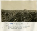
Looking N 80° E at the head of To-Chin-Sin canyon. Pastora Peak in right background. Cliffs through middle ground are monzonite porphyry.
P0013 Herbert E. Gregory Photograph Collection
P0013n07_013_1054
25
Butte, junction Sagy canyon with middle of East Branch, Ariz., 1910 (Photo G162)
P0013 Herbert E. Gregory Photograph Collection
P0013n04_35_0567a
1
-
25
of
25