|
|
Title | Collection Number And Name | Photo Number |
| 1 |
 |
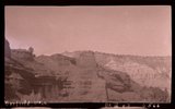
Lower end of Fable Valley near Junction with Beef Basin. Supai capped by Coconino, San Juan County, UT, 1928 | P0013 Herbert E. Gregory Photograph Collection | P0013n09_136_1984 |
| 2 |
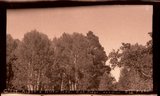 |
Aspen and Yellow Pine near Kigalia Ranger Station, Elk Ridge. San Juan County, UT, 1928 | P0013 Herbert E. Gregory Photograph Collection | P0013n09_120_1954 |
| 3 |
 |
Banded red and white sands. 'Marine Jurassic', immediately west of Cannonville, Garfield County, Utah | P0013 Herbert E. Gregory Photograph Collection | P0013n09_003_1726 |
| 4 |
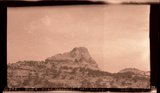 |
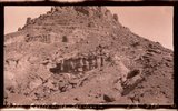
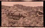
Butte of Coconino near mouth of Fable Valley. San Juan County, UT, 1928 | P0013 Herbert E. Gregory Photograph Collection | P0013n09_133_1977 |
| 5 |
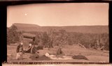 |
Camp scene, south bank of Armstrong Canyon looking northeast. Camp on Coconino; plateau in middle distance. Moenkopi capped by Shinarump; mesa in left background. Chinle and Glen Canyon, Fred Lowrey. San Juan County, UT, 1928 | P0013 Herbert E. Gregory Photograph Collection | P0013n09_124_1961 |
| 6 |
 |
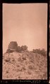
Castle Butte near mouth of Red Canyon Wingate on Chinle (showing details of Chinle beds); surrounding surface Shinarump, Zeke Johnson. San Juan County, UT, 1927 | P0013 Herbert E. Gregory Photograph Collection | P0013n09_092_1897 |
| 7 |
 |
Cave in Navajo sandstone east slope Comb monocline in Butler Wash, 11 miles from mouth. San Juan County, UT, 1928 | P0013 Herbert E. Gregory Photograph Collection | P0013n09_110_1933 |
| 8 |
 |
Chinle and Wingate in Stevens Valley. Branch of Indian Creek. San Juan County, UT, 1928 | P0013 Herbert E. Gregory Photograph Collection | P0013n09_127_1968 |
| 9 |
 |
Cliff dwellers watch tower, stone house branch of McElmo Canyon. Stands on Dakota sandstone. San Juan County, UT, 1928 | P0013 Herbert E. Gregory Photograph Collection | P0013n09_118_1949 |
| 10 |
 |
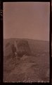
Contact of Supai (left) and shales occupying the position of the Coconino. Comb Wash in background. San Juan County, UT, 1928 | P0013 Herbert E. Gregory Photograph Collection | P0013n09_115_1944 |
| 11 |
 |
Desert weathering Panamint Valley | P0013 Herbert E. Gregory Photograph Collection | P0013n09_019_1756 |
| 12 |
 |
Details of middle Moenkopi. Head of Comb Wash. San Juan County, UT, 1927 | P0013 Herbert E. Gregory Photograph Collection | P0013n09_096_1906 |
| 13 |
 |
East side of Butler Wash, 77 Miles above its mouth. View taken standing on Navajo sandstone. Carmel (?), Entrada (?), Summerville (?), Salt Wahs (?), Morrison Shales, Dakota, San Juan County, Utah, 1928. | P0013 Herbert E. Gregory Photograph Collection | P0013n09_109_1931 |
| 14 |
 |
Erosion in Alluvial fill, Cottonwood Wash (Fred Lowrey). San Juan County, UT, 1928 | P0013 Herbert E. Gregory Photograph Collection | P0013n09_137_1986 |
| 15 |
 |
Erosion surface truncating beds below Shinarump west of Navajo Springs. Comb Wash in background. San Juan County, 1928 | P0013 Herbert E. Gregory Photograph Collection | P0013n09_111_1936 |
| 16 |
 |
General view walls of Dry Valley, Kane County, UT 1924 | P0013 Herbert E. Gregory Photograph Collection | P0013n09_010_1740 |
| 17 |
 |
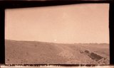
Gravel terrace at mouth of Recapture Creek, looking west along north bank of San Juan River. Salt Wash(?) forms Cliffs(?). San Juan County, UT, 1928 | P0013 Herbert E. Gregory Photograph Collection | P0013n09_103_1919 |
| 18 |
 |
Head of Hammond Canyon looking northeast. Coconino, Moenkopi, Shinarump (top of Elk Ridge). Abajo Mountains in right background. San Juan County, UT, 1928 | P0013 Herbert E. Gregory Photograph Collection | P0013n09_121_1955 |
| 19 |
 |
Head of Hammond Canyon looking south. Shinarump, Moenkopi, Coconino(?) San Juan County, UT, 1928 | P0013 Herbert E. Gregory Photograph Collection | P0013n09_125_1963 |
| 20 |
 |
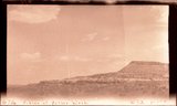
Looking across Beef Basin toward mouth of Green River, San Juan County, UT, 1928 | P0013 Herbert E. Gregory Photograph Collection | P0013n09_131_1973 |
| 21 |
 |
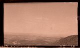
Looking down Cottonwood Canyon from point near Gooseberry Ranger Station. San Juan County, UT, 1928 | P0013 Herbert E. Gregory Photograph Collection | P0013n09_126_1966 |
| 22 |
 |
Looking down Notch Canyon from East Point, Elk Ridge, toward Chimney Park. Cottonwood Canyon in middle distance. Buttes of Navajo beyond Shay Mountains in distance. San Juan County, UT, 1928 | P0013 Herbert E. Gregory Photograph Collection | P0013n09_125_1964 |
| 23 |
 |
Looking east across Castle Wash at the point where old Mormon Road leaves the wash to go to Lake Canyon. San Juan County, UT, 1927 | P0013 Herbert E. Gregory Photograph Collection | P0013n09_084_1881 |
| 24 |
 |
Looking north down Mormon Pasture Creek to Cottonwood branch of Indian Creek. Chinle and Wingate. San Juan County, UT, 1928 | P0013 Herbert E. Gregory Photograph Collection | P0013n09_127_1967 |
| 25 |
 |
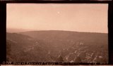
Looking northeast from east point, Elk Ridge across Cottonwood and Allen Canyons to Abajo Mountains. San Juan County, UT, 1928 | P0013 Herbert E. Gregory Photograph Collection | P0013n09_126_1965 |