Home
Browse
Ask Us
Chat
Harmful Language Statement
Log in
Photo Archives
Advanced Search
About
Over 70,000 photos covering a variety of topics from Marriott Library Special Collections
Year
1875
1876
1877
1878
1879
1880
1881
1882
1883
1884
1885
1886
1887
1888
1889
1890
1891
1892
1893
1894
1895
1896
1897
1898
1899
1900
1901
1902
1903
1904
1905
1906
1907
1908
1909
1910
1911
1912
1913
1914
1915
1916
1917
1918
1919
1920
1921
1922
1923
1924
1925
1926
1927
1928
1929
1930
1931
1932
1933
1934
1935
1936
1937
1938
1939
1940
1941
1942
1943
1944
1945
TO
1875
1876
1877
1878
1879
1880
1881
1882
1883
1884
1885
1886
1887
1888
1889
1890
1891
1892
1893
1894
1895
1896
1897
1898
1899
1900
1901
1902
1903
1904
1905
1906
1907
1908
1909
1910
1911
1912
1913
1914
1915
1916
1917
1918
1919
1920
1921
1922
1923
1924
1925
1926
1927
1928
1929
1930
1931
1932
1933
1934
1935
1936
1937
1938
1939
1940
1941
1942
1943
1944
1945
Type
Image
70
Format
application/pdf
70
Collection
Photo Archives
70
Filters:
Collection Name:
"Herbert E. Gregory"
Format:
"application/pdf"
51
-
75
of
70
<
1
2
3
>
Gallery view
Number of results to display per page
10
25
50
100
200
Sort by Relevance
Sort by Title A-Z
Sort by Title Z-A
Sort by Date Ascending
Sort by Date Descending
Sort by Last Modified Ascending
Sort by Last Modified Descending
Title
Date
Type
51
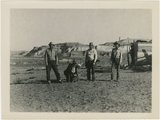
Paria Valley camp, 1943
1943
Image
52
Paria Valley camp, 1943
1943
Image
53
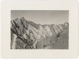
Ridge of uptilted strata
1940
Image
54
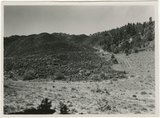
Road and lava field, Rock Creek Valley, Utah
1943; 1944; 1945
Image
55
Rocky cliff near Hillsdale
1943; 1944; 1945
Image
56
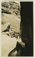
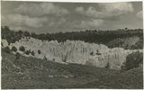
Sandstone outcrops, Paria Canyon, Utah
1943; 1944; 1945
Image
57
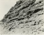
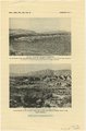
Section of the Shinarump Cliffs (middle distance), east of Pioneer Gap. Shinarump conglomerate exposed by erosion of Moenkopi formation below and the basal strata of the Chinle formation above. Upper Chinle sandstones form Vermilion Cliffs (background).
1944
Image
58
Sevier River formation overlaid by basalt near mouth of Corral Creek on Highway 89, 2 miles east of Panguitch. Garfield County, UT. 1944
1944
Image
59
Shinarump outcrop near Paria, 1943
1943
Image
60
Starlight Canyon 1943
1943
Image
61
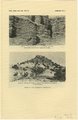
Unconformity between Moenkopi formation (lower part) and Shinarump conglomerate. Upper Chinle beds, middle top. Near mouth of Road Canyon. Kane County, UT. 1943
1943
Image
62
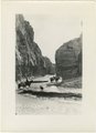
Upper Box in Paria Canyon just south of Cannonville
1943; 1944; 1945
Image
63
Views along Vermilion Cliffs [and] Permian and Triassic rocks at the mouth of Limestone Gulch
1943; 1944; 1945
Image
64
Views of the Moenkopi Formation [and] Triassic rocks
1943; 1944; 1945
Image
65
Warm Creek Canyon, June, 1915.
1915
Image
66
West wall of Seaman Wash
1944
Image
67
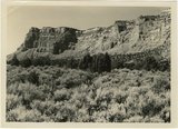
White cliffs along highway south of Asay Creek, Brian Head formation
1943; 1944; 1945
Image
68
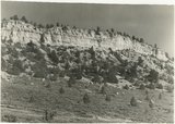
White rocks on road to Panquitch, Utah
1943; 1944; 1945
Image
69
Wingate Sandstone [and] Features of Jurassic and recent formation
1943; 1944; 1945
Image
70
Wingate sandstone, includes bed of limestone. Wall of Flood Canyon. Johnson Lakes. Kane County, UT. 1943
1943
Image
51
-
75
of
70
<
1
2
3
>