Home
Browse
Ask Us
Chat
Harmful Language Statement
Log in
Advanced Search
Year
1840
1841
1842
1843
1844
1845
1846
1847
1848
1849
1850
1851
1852
1853
1854
1855
1856
1857
1858
1859
1860
1861
1862
1863
1864
1865
1866
1867
1868
1869
1870
1871
1872
1873
1874
1875
1876
1877
1878
1879
1880
1881
1882
1883
1884
1885
1886
1887
1888
1889
1890
1891
1892
1893
1894
1895
1896
1897
1898
1899
1900
1901
1902
1903
1904
1905
1906
1907
1908
1909
1910
1911
1912
1913
1914
1915
1916
1917
1918
1919
1920
1921
1922
1923
1924
1925
1926
1927
1928
1929
1930
1931
1932
1933
1934
1935
1936
1937
1938
1939
1940
1941
1942
1943
1944
1945
1946
1947
1948
1949
1950
1951
1952
1953
1954
1955
1956
1957
1958
1959
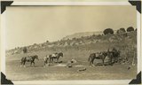
1960
1961
1962
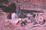
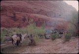
1963
1964
1965
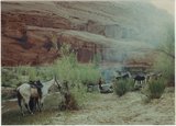
1966
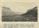
1967
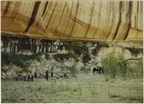
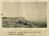
1968
1969
1970
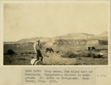
1971
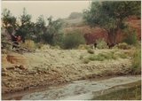
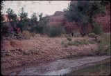
1972
1973
1974
1975
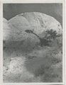
1976
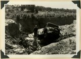
1977
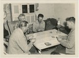
1978
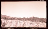
1979
1980
1981
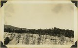
1982
1983
1984
1985
1986
1987
1988
1989
1990
1991
1992
1993
1994
1995
1996
1997
1998
1999
2000
2001
2002
2003
2004
2005
2006
2007
2008
TO
1840
1841
1842
1843
1844
1845
1846
1847
1848
1849
1850
1851
1852
1853
1854
1855
1856
1857
1858
1859
1860
1861
1862
1863
1864
1865
1866
1867
1868
1869
1870
1871
1872
1873
1874
1875
1876
1877
1878
1879
1880
1881
1882
1883
1884
1885
1886
1887
1888
1889
1890
1891
1892
1893
1894
1895
1896
1897
1898
1899
1900
1901
1902
1903
1904
1905
1906
1907
1908
1909
1910
1911
1912
1913
1914
1915
1916
1917
1918
1919
1920
1921
1922
1923
1924
1925
1926
1927
1928
1929
1930
1931
1932
1933
1934
1935
1936
1937
1938
1939
1940
1941
1942
1943
1944
1945
1946
1947
1948
1949
1950
1951
1952
1953
1954
1955
1956
1957
1958
1959
1960
1961
1962
1963
1964
1965
1966
1967
1968
1969
1970
1971
1972
1973
1974
1975
1976
1977
1978
1979
1980
1981
1982
1983
1984
1985
1986
1987
1988
1989
1990
1991
1992
1993
1994
1995
1996
1997
1998
1999
2000
2001
2002
2003
2004
2005
2006
2007
2008
Type
Image
1,299
Image/StillImage
116
Text
53
Sound
2
Format
image/jpeg
1,411
application/pdf
115
video/mp4
2
Collection
Beckwith Photograph Collection
9
Glen Canyon
1
Hiram B. Clawson Papers
1
Mormon Settlement in Arizona
2
Photo Archives
1,304
UAIDA Main Collection
2
Utah Humanities Research Foundation
2
Utah Quilt Heritage Records
44
Utah River Running Photo Archives
158
Western Soundscape
2
Western Waters NEH
2
Westminster University Photographs
2
More
Filters:
Spatial Coverage:
"Kane County (Utah)"
126
-
150
of
1,529
<
1
2
3
4
5
6
7
8
9
10
>
Gallery view
Number of results to display per page
10
25
50
100
200
Sort by Relevance
Sort by Title A-Z
Sort by Title Z-A
Sort by Date Ascending
Sort by Date Descending
Sort by Last Modified Ascending
Sort by Last Modified Descending
Title
Date
Type
Setname
126
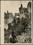
Bryce Canyon, Arch of Victory
1921
uum_map
127
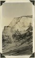
Butte eroded from Navajo sandstone, capped by iron concretion, Zion-Mount Carmel highway, Kane County, Utah, 1931.
1931
Image
uum_map
128
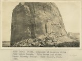
Butte, composed of massive white rock below Dakota. Note horse and rider. Lower Wahweap Valley. Kane County, UT. 1922
1922
Image
uum_map
129
Buttes of Cretaceous sandstone including fossil wood, bones of turtles, and dinosaurs (?) near head of Sheep Creek. Kane County, Utah, 1931.
1931
Image
uum_map
130
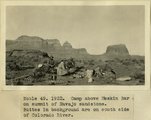
Camp above Meskin Bar on summit of navajo sandstone. Buttes in background are on south side of Colorado
1922
Image
uum_map
131
Camp activity at breakfast time, second day
1963-04-23
Image
uum_map
132
Camp at base of cliff
1964-05
Image
uum_map
133
Camp in floor of ancient lake bed; mesa of Navajo sandstone in background. Kitchen Rach, Kane County, Utah, 1931.
1931
Image
uum_map
134
Camp in Kanab Canyon 2 miles below mouth of Snake Gulch
1915
Image
uum_map
135
Camp in Kanab Canyon 2 miles below mouth of Snake Gulch. Gregory rolling bed. AZ. 1922
1922
Image
uum_map
136
Camp on rim of Kaiparowitz Plateau
1922
Image
uum_map
137
Camp on rim of Kaiparowitz Plateau
1922
Image
uum_map
138
Camp quilt, by Hester J. Payne Heaton
1930; 1931; 1932; 1933; 1934; 1935; 1936; 1937; 1938; 1939; 1940; 1941; 1942; 1943; 1944; 1945; 1946; 1947; 1948; 1949
Text
uum_uqhr
139
Camp scene, 30 miles east of Escalante. Kaiparowitz Plateau in background. Dr. Noble in foreground. Kane County, UT. 1922
1922
Image
uum_map
140
Campsite, Escalante canyon country
1964-05
Image
uum_map
141
Campsite, Escalante canyon country
1964-05
Image
uum_map
142
Campsite, Escalante canyon: Ken Sleight expedition, May 1964
1964-05
Image
uum_map
143
Campsite, Escalante canyon: Ken Sleight expedition, May 1964
1964-05
Image
uum_map
144
Canyon under natural bridge
1920; 1921; 1922; 1923; 1924; 1925; 1926; 1927; 1928; 1929; 1930; 1931; 1932; 1933; 1934; 1935; 1936; 1937; 1938; 1939; 1940; 1941; 1942; 1943; 1944; 1945; 1946; 1947; 1948; 1949
Image
uum_map_rr
145
Car washed into a ravine by flood. Skutumpah-Swallow Park road
1940
Image
uum_map
146
Card players, Paria Valley camp, 1943
1943
Image
uum_map
147
Carmel (bottom), Entrada (slope), Curtis (cliff of gypsum) and Winsor formation (top slope), Meadow Brook Canyon, Kane County, UT, 1939
1939
Image
uum_map
148
Carmel Flume (dry) Canyon, N.E. Glendale
1936
Image
uum_map
149
Carmel Flume (dry) Canyon, N.E. Glendale. 1936.
1936
Image
uum_map
150
Carmel formation (cliff) at head of Flume Canyon upthrow (east) side of Sevier fault which trends northeasterly. Cretaceous formations (background) at level of Jurassic. Kane County, UT. 1939
1939
Image
uum_map
126
-
150
of
1,529
<
1
2
3
4
5
6
7
8
9
10
>