Home
Browse
Ask Us
Chat
Harmful Language Statement
Log in
Advanced Search
Year
1911
1912
1913
1914
1915
1916
1917
1918
1919
1920
1921
1922
1923
1924
1925
1926
1927
1928
1929
1930
1931
1932
1933
1934
1935
1936
1937
1938
1939
1940
1941
1942
1943
1944
1945
1946
1947
1948
1949
1950
1951
1952
1953
1954
1955
1956
1957
1958
1959
1960
1961
1962
1963
1964
1965
1966
1967
1968
1969
1970
1971
1972
1973
1974
1975
1976
1977
1978
1979
1980
1981
1982
1983
1984
1985
1986
1987
1988
1989
1990
1991
1992
1993
1994
1995
1996
1997
1998
1999
2000
2001
2002
2003
2004
2005
2006
2007
2008
2009
2010
TO
1911
1912
1913
1914
1915
1916
1917
1918
1919
1920
1921
1922
1923
1924
1925
1926
1927
1928
1929
1930
1931
1932
1933
1934
1935
1936
1937
1938
1939
1940
1941
1942
1943
1944
1945
1946
1947
1948
1949
1950
1951
1952
1953
1954
1955
1956
1957
1958
1959
1960
1961
1962
1963
1964
1965
1966
1967
1968
1969
1970
1971
1972
1973
1974
1975
1976
1977
1978
1979
1980
1981
1982
1983
1984
1985
1986
1987
1988
1989
1990
1991
1992
1993
1994
1995
1996
1997
1998
1999
2000
2001
2002
2003
2004
2005
2006
2007
2008
2009
2010
Type
Image/StillImage
48
Image
34
Sound
3
Format
image/jpeg
84
video/mp4
2
audio/mpeg
1
Collection
Photo Archives
38
Ski and Snow Sports Archives
46
Western Soundscape
3
Filters:
Spatial Coverage:
"Peru"
76
-
100
of
87
<
1
2
3
4
>
Gallery view
Number of results to display per page
10
25
50
100
200
Sort by Relevance
Sort by Title A-Z
Sort by Title Z-A
Sort by Date Ascending
Sort by Date Descending
Sort by Last Modified Ascending
Sort by Last Modified Descending
Title
Date
Type
Setname
76
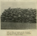
Pile of Yareta on the railroad between Mollendo and Juliaca, a resinous root which is used as fuel.
1911
Image
uum_map
77
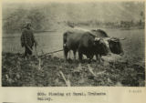
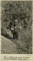
Plowing at Tarai, Urubamba valley.
1911
Image
uum_map
78
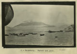
Salaverry, harbor and pier
1911
Image
uum_map
79
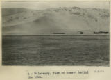
Salaverry. View of desert behind the town.
1911
Image
uum_map
80
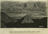
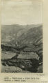
San Geronimo from foot of Mt. Picol
1912
Image
uum_map
81
Sedge Wren
2005-11-17
Sound
uu_wss
82
Urubamba to Cuzco. Cargo trains of relics from Machu Picchu.
1911
Image
uum_map
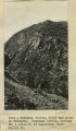
83
Urubamba Valley, cliff and gorge on Urubamba. Huatenay Divide, looking SW, 4 miles N. of Angostura. Elev. 14,000 ft.
1912; 1913; 1914; 1915
Image
uum_map
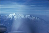
84
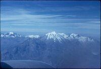
View of mountains from plane on trip from Lima, Peru to La Paz, Bolivia [01]
1962
Image/StillImage
uum_map
85
View of mountains from plane on trip from Lima, Peru to La Paz, Bolivia [02]
1962
Image/StillImage
uum_map
86
View of mountains from plane on trip from Lima, Peru to La Paz, Bolivia [03]
1962
Image/StillImage
uum_map
87
Yaurisque, view from the Paruro-Cuzco Road.
1912; 1913; 1914; 1915
Image
uum_map
76
-
100
of
87
<
1
2
3
4
>