| Title | Date | Type | Setname | ||
|---|---|---|---|---|---|
| 151 |
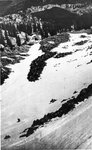 |
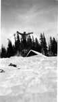
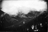
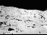
June 15 at noon down between Tuscarora and Wolverine. Lake Mary in background. | 1937; 1938; 1939; 1940; 1941 | uum_map_usa | |
| 152 |
 |
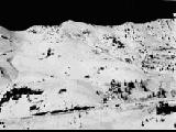
June 15, between Tuscarora and Wolverine | 1937; 1938; 1939; 1940; 1941 | uum_map_usa | |
| 153 |
 |
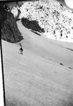
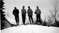
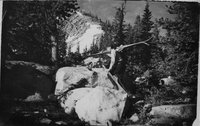
Karl Fahrner on Baldy | 1937; 1938; 1939; 1940; 1941 | uum_map_usa | |
| 154 |
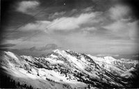 |
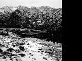
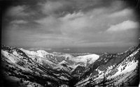
Kessler Peak and upper part of Mill D. Perfect for avalanches at left | 1938; 1939; 1940; 1941 | uum_map_usa | |
| 155 |
 |
Krantz ski jumping at Ferryland | 1936; 1937; 1938; 1939; 1940 | uum_map_usa | |
| 156 |
 |
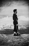
Krantz, Jeep, Ted Major and Bill Lence | 1936; 1937; 1938; 1939; 1940 | uum_map_usa | |
| 157 |
 |
Lake Mary, head of Big Cottonwood Canyon | 1910; 1911; 1912; 1913; 1914; 1915; 1916; 1917; 1918; 1919; 1920; 1921; 1922; 1923; 1924; 1925; 1926; 1927; 1928; 1929; 1930; 1931; 1932; 1933; 1934; 1935; 1936; 1937; 1938; 1939; 1940; 1941; 1942; 1943; 1944; 1945 | Image/StillImage | uum_map |
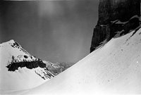
| 158 |
 |
Large alpine cirque, upper Gad Valley, Twin Peaks | 1937; 1938; 1939; 1940; 1941; 1942; 1943; 1944; 1945; 1946; 1947; 1948; 1949; 1950; 1951; 1952; 1953; 1954; 1955; 1956; 1957; 1958; 1959; 1960; 1961; 1962; 1963; 1964; 1965; 1966; 1967; 1968; 1969 | uum_map_usa | |
| 159 |
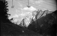 |
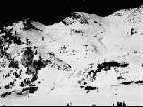
Lift on June 17, with Dee and Chick up Collins Gulch, snowed 1 foot that night | 1937; 1938; 1939; 1940; 1941 | uum_map_usa | |
| 160 |
 |
Looking down Vail Ridge | 1937; 1938; 1939; 1940; 1941; 1942; 1943; 1944; 1945; 1946; 1947; 1948; 1949; 1950; 1951; 1952; 1953; 1954; 1955; 1956; 1957; 1958; 1959; 1960; 1961; 1962; 1963; 1964; 1965; 1966; 1967; 1968; 1969 | uum_map_usa | |
| 161 |
 |
Looking down Vail Ridge | 1937; 1938; 1939; 1940; 1941; 1942; 1943; 1944; 1945; 1946; 1947; 1948; 1949; 1950; 1951; 1952; 1953; 1954; 1955; 1956; 1957; 1958; 1959; 1960; 1961; 1962; 1963; 1964; 1965; 1966; 1967; 1968; 1969 | uum_map_usa | |
| 162 |
 |
Looking north east from just above Emerald Lake | 1935; 1936; 1937; 1938; 1939; 1940; 1941; 1942; 1943; 1944; 1945; 1946; 1947; 1948; 1949 | uum_map_usa | |
| 163 |
 |
Looking north east from just above Emerald Lake (Negative) | 1935; 1936; 1937; 1938; 1939; 1940; 1941; 1942; 1943; 1944; 1945; 1946; 1947; 1948; 1949 | uum_map_usa | |
| 164 |
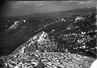 |
Looking toward Heber Valley from vicinity of Albion Pass? | 1937; 1938; 1939; 1940; 1941 | uum_map_usa | |
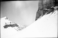
| 165 |
 |
Marble Cliffs below Alta, edge of Superior | 1937; 1938; 1939; 1940; 1941 | uum_map_usa | |
| 166 |
 |
McConnell nearing shoulder of Baldy | 1937; 1938; 1939; 1940; 1941 | uum_map_usa | |
| 167 |
 |
Mill D. Fork and Big Cottonwood | 1938; 1939; 1940; 1941 | uum_map_usa | |
| 168 |
 |
Miniature of upper Little Cottonwood Canyon | 1937; 1938; 1939; 1940; 1941; 1942; 1943; 1944; 1945; 1946; 1947; 1948; 1949; 1950; 1951; 1952; 1953; 1954; 1955; 1956; 1957; 1958; 1959; 1960; 1961; 1962; 1963; 1964; 1965; 1966; 1967; 1968; 1969 | uum_map_usa | |
| 169 |
 |
Miniature of upper Little Cottonwood Canyon | 1937; 1938; 1939; 1940; 1941; 1942; 1943; 1944; 1945; 1946; 1947; 1948; 1949; 1950; 1951; 1952; 1953; 1954; 1955; 1956; 1957; 1958; 1959; 1960; 1961; 1962; 1963; 1964; 1965; 1966; 1967; 1968; 1969 | uum_map_usa | |
| 170 |
 |
Miniature of upper Little Cottonwood Canyon | 1937; 1938; 1939; 1940; 1941; 1942; 1943; 1944; 1945; 1946; 1947; 1948; 1949; 1950; 1951; 1952; 1953; 1954; 1955; 1956; 1957; 1958; 1959; 1960; 1961; 1962; 1963; 1964; 1965; 1966; 1967; 1968; 1969 | uum_map_usa | |
| 171 |
 |
Miniature of upper Little Cottonwood Canyon | 1937; 1938; 1939; 1940; 1941; 1942; 1943; 1944; 1945; 1946; 1947; 1948; 1949; 1950; 1951; 1952; 1953; 1954; 1955; 1956; 1957; 1958; 1959; 1960; 1961; 1962; 1963; 1964; 1965; 1966; 1967; 1968; 1969 | uum_map_usa | |
| 172 |
 |
Miniature of upper Little Cottonwood Canyon | 1937; 1938; 1939; 1940; 1941; 1942; 1943; 1944; 1945; 1946; 1947; 1948; 1949; 1950; 1951; 1952; 1953; 1954; 1955; 1956; 1957; 1958; 1959; 1960; 1961; 1962; 1963; 1964; 1965; 1966; 1967; 1968; 1969 | uum_map_usa | |
| 173 |
 |
Miniature of upper Little Cottonwood Canyon. "Snow ranger's lair with its' forest of radio masts 8 weather instrument towers." | 1937; 1938; 1939; 1940; 1941; 1942; 1943; 1944; 1945; 1946; 1947; 1948; 1949; 1950; 1951; 1952; 1953; 1954; 1955; 1956; 1957; 1958; 1959; 1960; 1961; 1962; 1963; 1964; 1965; 1966; 1967; 1968; 1969 | uum_map_usa | |
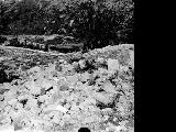
| 174 |
 |
Moraine about five miles up Little Cottonwood Canyon | 1910; 1911; 1912; 1913; 1914; 1915; 1916; 1917; 1918; 1919; 1920; 1921; 1922; 1923; 1924; 1925; 1926; 1927; 1928; 1929; 1930; 1931; 1932; 1933; 1934; 1935; 1936; 1937; 1938; 1939; 1940; 1941; 1942; 1943; 1944; 1945 | Image/StillImage | uum_map |
| 175 |
 |
Morainic mass extending across Little Cottonwood Canyon | 1910; 1911; 1912; 1913; 1914; 1915; 1916; 1917; 1918; 1919; 1920; 1921; 1922; 1923; 1924; 1925; 1926; 1927; 1928; 1929; 1930; 1931; 1932; 1933; 1934; 1935; 1936; 1937; 1938; 1939; 1940; 1941; 1942; 1943; 1944; 1945 | Image/StillImage | uum_map |