|
|
Title | Date | Type | Setname |
| 1 |
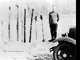 |
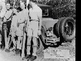
"Harry Duerkop thumbing a ride." | 1933 | Image | uum_map_usa |
| 2 |
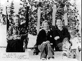 |
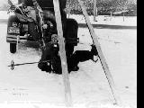
"Lunch time. From Park City to Brighton. Harry Duerkop, Sally Barnard and Ralph Johnston." | 1934 | Image | uum_map_usa |
| 3 |
 |
"On divide of old road entering Wheeler Basin from Huntsville side. (Close to Snow Basin)" | 1930; 1931; 1932; 1933; 1934; 1935; 1936; 1937; 1938; 1939; 1940; 1941; 1942; 1943; 1944; 1945; 1946; 1947; 1948; 1949; 1950; 1951; 1952; 1953; 1954; 1955; 1956; 1957; 1958; 1959; 1960; 1961; 1962; 1963; 1964; 1965; 1966; 1967; 1968; 1969 | | uum_map_usa |
| 4 |
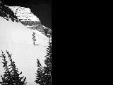 |
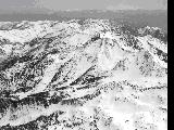
"Ski bowls under Mt. Timpanogos - near Emerald Lake, one of Utah's most fantastic snow lands of the Wasatch Mountains." | 1937; 1938; 1939; 1940; 1941; 1942; 1943; 1944; 1945; 1946; 1947; 1948; 1949; 1950; 1951; 1952; 1953; 1954; 1955; 1956; 1957; 1958; 1959; 1960; 1961; 1962; 1963; 1964; 1965; 1966; 1967; 1968; 1969 | | uum_map_usa |
| 5 |
 |
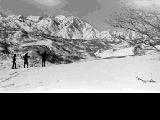
"The Climber," man climbing a rock cliff near Brighton | 1931-11-26 | Image | uum_map |
| 6 |
 |
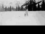
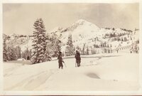
A spring ski trip, L to R: Ralph Johnston, Carol Lindsay, Sally Barnard, and Fred Speyer. | 1934 | Image | uum_map_usa |
| 7 |
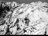 |
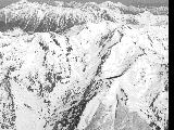
Aerial of the south side of Twin Peaks also showing Mineral Basin and Mary Ellen Gulch | 1937; 1938; 1939; 1940; 1941; 1942; 1943; 1944; 1945; 1946; 1947; 1948; 1949; 1950; 1951; 1952; 1953; 1954; 1955; 1956; 1957; 1958; 1959; 1960; 1961; 1962; 1963; 1964; 1965; 1966; 1967; 1968; 1969 | | uum_map_usa |
| 8 |
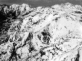 |
Aerial, east side of Twin Peaks, with Mineral Basin and Marry Ellen Gulch | 1937; 1938; 1939; 1940; 1941; 1942; 1943; 1944; 1945; 1946; 1947; 1948; 1949; 1950; 1951; 1952; 1953; 1954; 1955; 1956; 1957; 1958; 1959; 1960; 1961; 1962; 1963; 1964; 1965; 1966; 1967; 1968; 1969 | | uum_map_usa |
| 9 |
 |
Aerial, Twin Peaks | 1937; 1938; 1939; 1940; 1941; 1942; 1943; 1944; 1945; 1946; 1947; 1948; 1949; 1950; 1951; 1952; 1953; 1954; 1955; 1956; 1957; 1958; 1959; 1960; 1961; 1962; 1963; 1964; 1965; 1966; 1967; 1968; 1969 | | uum_map_usa |
| 10 |
 |
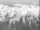
Aerial, Twin Peaks and Major Evans Gulch | 1937; 1938; 1939; 1940; 1941; 1942; 1943; 1944; 1945; 1946; 1947; 1948; 1949; 1950; 1951; 1952; 1953; 1954; 1955; 1956; 1957; 1958; 1959; 1960; 1961; 1962; 1963; 1964; 1965; 1966; 1967; 1968; 1969 | | uum_map_usa |
| 11 |
 |
Aerial, White Pine and Twin Peaks | 1937; 1938; 1939; 1940; 1941; 1942; 1943; 1944; 1945; 1946; 1947; 1948; 1949; 1950; 1951; 1952; 1953; 1954; 1955; 1956; 1957; 1958; 1959; 1960; 1961; 1962; 1963; 1964; 1965; 1966; 1967; 1968; 1969 | | uum_map_usa |
| 12 |
 |
Base of early Brighton chairlift | 1955; 1956; 1957; 1958; 1959 | | uum_map_usa |
| 13 |
 |
Big Cottonwood Canyon | 1920; 1921; 1922; 1923; 1924; 1925; 1926; 1927; 1928; 1929; 1930 | Image/StillImage | uum_map |
| 14 |
 |
Big Cottonwood Canyon | 1936-02-14 | | uum_map_usa |
| 15 |
 |
Big Cottonwood Canyon | 1936-02-15 | | uum_map_usa |
| 16 |
 |
Big Cottonwood Canyon | 1936-02-15 | | uum_map_usa |
| 17 |
 |
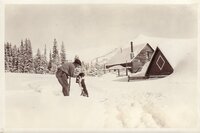
Bill Osmond with skis on his back. | 1933 | Image | uum_map_usa |
| 18 |
 |
Brighton, Utah, in winter [01] | 1920; 1921; 1922; 1923; 1924; 1925; 1926; 1927; 1928; 1929; 1930 | Image/StillImage | uum_map |
| 19 |
 |
Brighton, Utah, in winter [02] | 1920; 1921; 1922; 1923; 1924; 1925; 1926; 1927; 1928; 1929; 1930 | Image/StillImage | uum_map |
| 20 |
 |
Brighton, Utah, in winter [03] | 1920; 1921; 1922; 1923; 1924; 1925; 1926; 1927; 1928; 1929; 1930 | Image/StillImage | uum_map |
| 21 |
 |
Brighton, Utah, in winter [04] | 1921-02-22 | Image/StillImage | uum_map |
| 22 |
 |
Brighton, Utah, in winter [05] | 1920; 1921; 1922; 1923 | Image/StillImage | uum_map |
| 23 |
 |
Brighton, Utah, in winter [06] | 1920; 1921; 1922; 1923 | Image/StillImage | uum_map |
| 24 |
 |
Brighton, Utah, in winter [07] | 1920; 1921; 1922; 1923 | Image/StillImage | uum_map |
| 25 |
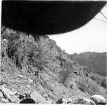 |
Cambrian slates at bottom of Big Cottonwood Canyon | 1910; 1911; 1912; 1913; 1914; 1915; 1916; 1917; 1918; 1919; 1920; 1921; 1922; 1923; 1924; 1925; 1926; 1927; 1928; 1929; 1930; 1931; 1932; 1933; 1934; 1935; 1936; 1937; 1938; 1939; 1940; 1941; 1942; 1943; 1944; 1945 | Image/StillImage | uum_map |