Home
Browse
Ask Us
Chat
Harmful Language Statement
Log in
Advanced Search
Year
1850
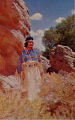
1851
1852
1853
1854
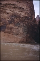
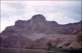
1855
1856
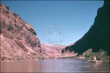
1857
1858
1859
1860
1861
1862
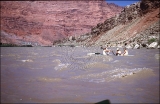
1863
1864
1865
1866
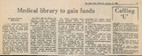
1867
1868
1869
1870
1871
1872
1873
1874
1875
1876
1877
1878
1879
1880
1881
1882
1883
1884
1885
1886
1887
1888
1889
1890
1891
1892
1893
1894
1895
1896
1897
1898
1899
1900
1901
1902
1903
1904
1905
1906
1907
1908
1909
1910
1911
1912
1913
1914
1915
1916
1917
1918
1919
1920
1921
1922
1923
1924
1925
1926
1927
1928
1929
1930
1931
1932
1933
1934
1935
1936
1937
1938
1939
1940
1941
1942
1943
1944
1945
1946
1947
1948
1949
1950
1951
1952
1953
1954
1955
1956
1957
1958
1959
1960
1961
1962
1963
1964
1965
1966
1967
1968
1969
1970
1971
1972
1973
1974
1975
1976
1977
1978
1979
1980
1981
1982
1983
1984
1985
1986
1987
1988
1989
1990
1991
1992
1993
1994
1995
1996
1997
1998
1999
2000
2001
2002
2003
2004
2005
2006
2007
2008
2009
2010
2011
2012
2013
2014
2015
2016
2017
2018
2019
2020
2021
2022
2023
TO
1850
1851
1852
1853
1854
1855
1856
1857
1858
1859
1860
1861
1862
1863
1864
1865
1866
1867
1868
1869
1870
1871
1872
1873
1874
1875
1876
1877
1878
1879
1880
1881
1882
1883
1884
1885
1886
1887
1888
1889
1890
1891
1892
1893
1894
1895
1896
1897
1898
1899
1900
1901
1902
1903
1904
1905
1906
1907
1908
1909
1910
1911
1912
1913
1914
1915
1916
1917
1918
1919
1920
1921
1922
1923
1924
1925
1926
1927
1928
1929
1930
1931
1932
1933
1934
1935
1936
1937
1938
1939
1940
1941
1942
1943
1944
1945
1946
1947
1948
1949
1950
1951
1952
1953
1954
1955
1956
1957
1958
1959
1960
1961
1962
1963
1964
1965
1966
1967
1968
1969
1970
1971
1972
1973
1974
1975
1976
1977
1978
1979
1980
1981
1982
1983
1984
1985
1986
1987
1988
1989
1990
1991
1992
1993
1994
1995
1996
1997
1998
1999
2000
2001
2002
2003
2004
2005
2006
2007
2008
2009
2010
2011
2012
2013
2014
2015
2016
2017
2018
2019
2020
2021
2022
2023
Type
Image
9,275
Image/StillImage
379
Text
20
Image/MovingImage
1
Format
image/jpeg
9,744
Collection
Clifton Bray Film Negatives
1
College of Nursing
21
College of Pharmacy
103
Eccles Health Sciences Library History
43
Extractions from the Land: Mining and...
55
History of the Health Sciences
707
Lennox and Catherine Tierney Photogra...
14
Maps
300
More Than A Flag: Utah State Flag Red...
7,024
Park City Historical Society & Museum
3
Peoples of Utah Revisited
4
Photo Archives
46
Ski and Snow Sports Archives
2
Thorne Photographs
1
Topaz Museum
4
UAIDA Main Collection
52
University Archival Photographs (P0305)
1,250
Utah COVID-19
20
Utah River Running Photo Archives
61
Vernal Express Photographs
5
Western Soundscape Spectrograms
28
More
Filters:
Subject:
"Utah"
Format:
"image/jpeg"
1
-
25
of
9,744
<
1
2
3
4
5
6
7
8
9
10
>
Gallery view
Number of results to display per page
10
25
50
100
200
Sort by Relevance
Sort by Title A-Z
Sort by Title Z-A
Sort by Date Ascending
Sort by Date Descending
Sort by Last Modified Ascending
Sort by Last Modified Descending
Title
Date
Type
Setname
1
"1896" and "Utah" with red, white and blue star in center
2022
Image
dha_mtaf
2
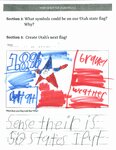
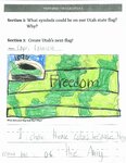
"1896" and a green and black army tank in upper left corner with green camouflage stripes and "Freedom"
2022
Image
dha_mtaf
3
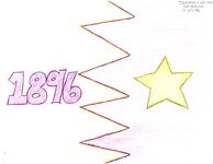
"1896" in purple on the white the left side of ziig zagged divided line with a purple of the opposite side holding a gold star
2002-01-29
Image
dha_mtaf
4
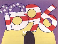
"1896" in red, white and blue with stars and stripes in front of a beehive and bee on a purple field
2002
Image
dha_mtaf
5
"A 3 second view of a peak of Kaiparowitz Plateau at mile 66.5"
1951-05-16
uum_map_rr
6
"At mile 15 Frank pointed out to us one of the Bureau of Reclamation proposed sites for a dam to be built, horrors!"
1951-05-17
uum_map_rr
7
"Boat barge created as we pulled in together for a short interval. Olive, Joe, Don, Jack, Verona, Wyman."
1951-05
uum_map_rr
8
"Boat is put on truck then loaded with people and duffel for drive over rough road to Art Greene's Lodge."
1951-05-17
uum_map_rr
9
"Cherry Blossom" a Ute Indian Maiden from U and O
Image/StillImage
uaida_main
10
"Chief of National Medicine Library Will Speak at InfoFair Seminar at U." The Daily Utah Chronicle, Thursday, February 21, 1985
1985
Text
ehsl_history
11
"Construction of Medical Library Set." The Daily Utah Chronicle, November 14, 1969
1969
Text
ehsl_hhs
12
"Don Smith, Frank Wright and Jack Rigg. Mexican Hat Expeditions. 5-17-51."
1951-05-17
uum_map_rr
13
"Eastward from Mile 61 to Wild Horse Mesa."
1951-05-16
uum_map_rr
14
"House where John D Lee lived and operated the ferry."
1951-05-17
uum_map_rr
15
"Landing at Lee's Ferry end of our 162 mile boat trip through Glen Canyon of Colorado."
1951-05-17
uum_map_rr
16
"Last Rapid Paria Creek."
1951-05-17
uum_map_rr
17
"Looking back NE over 4 mile straight stretch. Mile 51"
1951-05
uum_map_rr
18
"Looking down onto the boats at mouth of Kane Creek. Wyman, Verona, M."
1951-05-16
uum_map_rr
19
"Looking East out of Outlaw Cave 160x40x30. Over last night camp site. Mile 17"
1951-05-16
uum_map_rr
20
"Lunch at Kane Creek. 5-16-51."
1951-05-16
uum_map_rr
21
"Lunch stop on SW bank of Colorado River at mile 9.5"
1951-05-17
uum_map_rr
22
"M. by tamarisk looking East from Kane Creek above crossing of the Fathers."
1951-05-16
uum_map_rr
23
"Marjorie and Barbara at end of trail after 7 days of river life. 5-17-51."
1951-05-17
uum_map_rr
24
"Marjorie looking over river map and making a final note. Art Greene's Power boat moored nearby."
1951-05-17
uum_map_rr
25
"Medical Library to Gain Funds." The Daily Utah Chronicle, January 17, 1969
1969
Text
ehsl_hhs
1
-
25
of
9,744
<
1
2
3
4
5
6
7
8
9
10
>