Home
Browse
Ask Us
Chat
Harmful Language Statement
Log in
Institutional Repository
Advanced Search
Year
1905
1906
1907
1908
1909
1910
1911
1912
1913
1914
1915
1916
1917
1918
1919
1920
1921
1922
1923
1924
1925
1926
1927
1928
1929
1930
1931
1932
1933
1934
1935
1936
1937
1938
1939
1940
1941
1942
1943
1944
1945
1946
1947
1948
1949
1950
1951
1952
1953
1954
1955
1956
1957
1958
1959
1960
1961
1962
1963
1964
1965
1966
1967
1968
1969
1970
1971
1972
1973
1974
1975
1976
1977
1978
1979
1980
1981
1982
1983
1984
1985
1986
1987
1988
1989
1990
1991
1992
1993
1994
1995
1996
1997
1998
1999
2000
2001
2002
2003
2004
2005
2006
2007
2008
2009
2010
2011
2012
2013
2014
2015
2016
2017
2018
2019
2020
2021
2022
TO
1905
1906
1907
1908
1909
1910
1911
1912
1913
1914
1915
1916
1917
1918
1919
1920
1921
1922
1923
1924
1925
1926
1927
1928
1929
1930
1931
1932
1933
1934
1935
1936
1937
1938
1939
1940
1941
1942
1943
1944
1945
1946
1947
1948
1949
1950
1951
1952
1953
1954
1955
1956
1957
1958
1959
1960
1961
1962
1963
1964
1965
1966
1967
1968
1969
1970
1971
1972
1973
1974
1975
1976
1977
1978
1979
1980
1981
1982
1983
1984
1985
1986
1987
1988
1989
1990
1991
1992
1993
1994
1995
1996
1997
1998
1999
2000
2001
2002
2003
2004
2005
2006
2007
2008
2009
2010
2011
2012
2013
2014
2015
2016
2017
2018
2019
2020
2021
2022
Type
Text
439
Image
135
Dataset
1
Format
application/pdf
464
application/zip
35
application/vnd.google-earth.kmz
34
image/jpeg
7
Collection
Data Registry and Repository
1
Honors Theses Closed Archive
1
Honors Theses Open Access
3
Theses & Dissertations
434
UScholar Works
100
Undergraduate Works
1
More
Filters:
Department:
"Geology & Geophysics"
1
-
25
of
540
<
1
2
3
4
5
6
7
8
9
10
>
Gallery view
Number of results to display per page
10
25
50
100
200
Sort by Relevance
Sort by Title A-Z
Sort by Title Z-A
Sort by Date Ascending
Sort by Date Descending
Sort by Last Modified Ascending
Sort by Last Modified Descending
Title
Date
Type
Setname
1
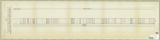
Columnar section of the permian unnamed formation exposed between Rydalch Pass and US Coast and geodetic survey Cedar Triangulation Station Plate VIII
Text
ir_etd
2
An individual migration story: comparing strontium isotope analysis in enamel, ivory, and food sources from a single modern elephant
Text
ir_uw
3
Unconventional petroleum system analysis using a 3D basin model: Mancos Shale, Uinta Basin, Utah supplementary material
Dataset
ir_drr
4
Concerning the Laramie Formation in Carbon County, Utah
1905
Text
ir_etd
5
Oil reserves in the oil shale and coal deposits of Utah
1905-04-15
Text
ir_etd
6
Gilsonite
1905-04-17
Text
ir_etd
7
General features of the Wasatch Mountains
1906
Text
ir_etd
8
The Igneous Rocks of Utah
1912
Text
ir_etd
9
Report on some building stones submitted for the Utah capitol
1912
Text
ir_etd
10
Map 1: Geologic map of Antelope intrusive and vicinity
1950
Image
ir_etd
11
Map 1: Geologic map of Antelope intrusive and vicinity (Google Earth map overlay KMZ file)
1950
Image
ir_etd
12
Heavy mineral study of the intrusive rocks of the Antelope Range, Piute County, Utah
1950
Text
ir_etd
13
Geology of the Keetley-Kamas volcanic area: Georeferenced map files
1951
Image
ir_etd
14
Geology of the Keetley-Kamas volcanic area
1951
Text; Image
ir_etd
15
Geology of the Smith and Morehouse-South Fork Area, Utah: Georeferenced map files
1951
Image
ir_etd
16
Plate 3 Geologic map of portion of Northwestern Uinta Mountains, Utah (Google Earth map overlay KMZ file)
1951
Image
ir_etd
17
Plate 3: Geologic map of portion of Northwestern Uinta Mountains, Utah
1951
Image
ir_etd
18
Geology of the Keetley-Kamas volcanic area (Google Earth map overlay KMZ file)
1951
Image
ir_etd
19
Geology of the Smith and Morehouse-South Fork Area, Utah
1951
Text
ir_etd
20
Map1 Geologic map and sections of Smith and Morehouse-Hayden Fork area, Utah (Google Earth map overlay KMZ file)
1952
Image
ir_etd
21
Geology of the Smith and Morehouse-Hayden Fork area, Utah
1952
Text; Image
ir_etd
22
Geology of the Wanship - Park City Region, Utah
1952-06
Text
ir_etd
23
Plate 3: Geologic map and sections of Wanship-Park City region, Utah (Google Earth map overlay KMZ file)
1952-06
Image
ir_etd
24
Plate 3: Geologic map and sections of Wanship-Park City region, Utah
1952-06
Image
ir_etd
25
Geology of the Wanship - Park City Region, Utah: Georeferenced map files
1952-06
Image
ir_etd
1
-
25
of
540
<
1
2
3
4
5
6
7
8
9
10
>