| Publication Type |
thesis |
| School or College |
College of Mines & Earth Sciences |
| Department |
Geology & Geophysics |
| Author |
Stark, Norman Paul |
| Title |
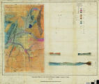
Areal geology of the Upton region, Summit County, Utah-Maps |
| Date |
1953-06 |
| Description |
Plates 4 and 5 from the thesis ""Areal geology of the Upton region, Summit County, Utah"". |
| Type |
Image |
| Publisher |
University of Utah |
| Dissertation Institution |
University of Utah |
| Dissertation Name |
Master of Science |
| Language |
eng |
| Relation is Version of |
Digital reproduction of plates from Areal geology of the Upton region, Summit County, Utah, J. Willard Marriott Library Special Collections, QE 3.5 1953 S73 |
| Rights Management |
In the public domain use of this file is allowed in accordance with the Creative Commons Attribution-Noncommercial-No Derivative Works 3.0 United States License, http://creativecommons.org/licenses/by-nc-nd/3.0/us |
| Format Medium |
image/jpeg (visual file) |
| Identifier |
us-etd3,28543 |
| Source |
Original: University of Utah J. Willard Marriott Library Special Collections |
| Conversion Specifications |
Original Scanned on Colortrac Smartlf GxT42 and saved as 300dpi tiff. Final display image generated by CONTENTdm. |
| ARK |
ark:/87278/s6ws9824 |
| Setname |
ir_etd |
| ID |
195432 |
| Reference URL |
https://collections.lib.utah.edu/ark:/87278/s6ws9824 |