| Publication Type |
thesis |
| School or College |
College of Mines & Earth Sciences |
| Department |
Geology & Geophysics |
| Author |
Doelling, Hellmut H. |
| Title |
Geology of the Northern Lakeside Mountains and the Grassy Mountains and vicinity, Tooele and Box Elder Counties, Utah |
| Date |
1964-06 |
| Description |
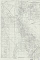
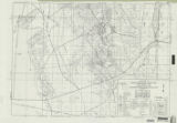
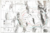
The northern Lakeside Mountains and the Grassy Mountains, part of the Basin and Range province, include about 500 square miles in northwestern Utah. The two side-by-side, north-south trending mountain ranges are located on the west side of Great Salt Lake, approximately 75 miles west of Salt Lake City, Utah. Twenty nine formations representing all Paleozoic periods are exposed. Included are 7,003 feet of Cambrian, 3,094 feet of Ordovician, 653 feet of Silurian, 2,462 feet of Devonian, 6,646 feet of Mississippian, 3,541 feet of Pennsylvanian, and 14,517 feet of Permian strata. The 37,916 foot measured section and the 43,293 foot estimated thickness of strata in the area represents one of the thickest Paleozoic sections in Utah. The northern Lakeside Mountains expose Cambrian to Pennsylvanian strata and the Grassy Mountains expose Pennsylvanian and Permian strata. A Tertiary basalt porphyry is found in the southwestern corner of the area, and the unconsolidated Quaternary alluvial and eluvial deposits in the intermontane area, complete the exposed rock suite of the area. Structurally the Grassy Mountains and the Lakeside Mountains are radically different. The Lakeside Mountains show structural patterns relating to the Paleocene uplift of the Northern Utah Highland dome, of which they found the west flank. These consist mainly of normal faults and open folds. An uplift in the Newfoundland area rising concurrently with the Northern Utah Highland uplift compressed the intervening Grassy Mountain area, overturning, tightly folding, and thrusting the strata. Both the Lakeside Mountains and the Grassy Mountains were later affected by Basin and Range block faulting. Grayback Mountain, in the southwest corner of the area, represents a Tertiary fissure-type eruption. Several related dikes are found in the Grassy Mountain area. Several mines, comprising the Lakeside mining district, are found in the central Lakeside Mountains. The ore deposits are fault-controlled and consist chiefly of oxidized lead and zinc materials. |
| Type |
Text; Image |
| Publisher |
University of Utah |
| Subject |
Geology -- Utah -- Tooele County; Geology -- Utah -- Box Elder County; Geology -- Utah -- Grassy Mountains -- Maps; Geology -- Utah -- Lakeside Mountains -- Maps |
| Dissertation Institution |
University of Utah |
| Dissertation Name |
Doctor of Philosophy |
| Language |
eng |
| Relation is Version of |
Digital reproduction of Geology of the Northern Lakeside Mountains and the Grassy Mountains and vicinity, Tooele and Box Elder Counties, Utah, J. Willard Marriott Library Special Collections, QE 3.5 1964 D63 |
| Rights Management |
In the public domain use of this file is allowed in accordance with the Creative Commons Attribution-Noncommercial-No Derivative Works 3.0 United States License, http://creativecommons.org/licenses/by-nc-nd/3.0/us |
| Format Medium |
application/pdf; image/jpeg |
| Identifier |
50,857 bytes |
| Source |
Original: University of Utah J. Willard Marriott Library Special Collections |
| Conversion Specifications |
Text: Original scanned on Epson GT-30000/Epson Expression 836XL as 400 dpi to pdf using ABBYY FineReader 9.0 Professional Edition. Images: Original Scanned on Colortrac Smartlf GxT42 and saved as 300dpi tiff. Final display image generated by CONTENTdm. |
| ARK |
ark:/87278/s62j6smh |
| Setname |
ir_etd |
| ID |
195361 |
| Reference URL |
https://collections.lib.utah.edu/ark:/87278/s62j6smh |