| Publication Type |
thesis |
| School or College |
College of Mines & Earth Sciences |
| Department |
Geology & Geophysics |
| Author |
Harrill, James Reece |
| Title |
Geology of the Davis Knolls and northern Big Davis Mountain area, Tooele County, Utah |
| Date |
1962-08 |
| Description |
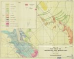
Three distinct topographic and structural features comprise the area located immediately south and southeast of the town of Dugway, Tooele County, Utah. These are, from west to east, Big Davis Mountain, Southern Skull Valley, and the Davis Knolls. Formations divisible at the northern end of Big Davis Mountain are: the Victoria-Pinyon Peak formation (253 feet thick), the Madison-Deseret formation (512 feet thick), the Humbug formation (796 feet thick), and the Great Blue formation (2,500 feet exposed). The latter is divisible into a lower limestone, a middle shale (the Chuilos), and an upper limestone member. * The Davis Knolls comprise faulted segments of the Oquirrh formation. Strata are near vertical or overturned and are progressively younger from west to east. The exposed segment of the Oquirrh formation (3,800 feet thick) ranges from Pennsylvanian to Permian (lower Virgil) in age. Southern Skull Valley is a graben which is filled by alluvium and volcanic rocks (hypersthene andesites). The volcanic rocks are found in proximity to the faults bordering the graben. Locally, steeply dipping Paleozoic rocks are unconformably overlain by a conglomerate postulated to be Cretaceous or younger in age. Structures present in the Big Davis Mountain portion of the area are a westward extension of the north-dipping Sheeprock Monocline; those present in the Davis Knolls portion of the area are a southern extension of the southeast trending folds of the Cedar Mountains. Normal faults of relatively large displacement are present on the west side of Big Davis Mountain and on the east side of the Davis Knolls. Normal faults of relatively smaller displacement, but which parallel the larger border faults are present. A set of older east trending normal faults is also present in the area immediately north of Big Davis Mountain. Terraces formed by Lake Bonneville are present at the Bonneville level (5,200 feet) and the Provo level (k,Q00 feet). A series of west trending gravel bars extend from the foothills of the Onaqui Mountains to the east side of the Davis Knolls. In the vicinity of Big Davis Mountain gravel spits are present on the south side of bedrock outcrops. |
| Type |
Text; Image |
| Publisher |
University of Utah |
| Subject |
Geology -- Utah -- Tooele County; Thesis and dissertation georeferencing project |
| Dissertation Institution |
University of Utah |
| Dissertation Name |
Master of Science |
| Language |
eng |
| Relation is Version of |
Digital reproduction of Geology of the Davis Knolls and northern Big Davis Mountain area, Tooele County, Utah J. Willard Marriott Library Special Collections, QE 3.5 1962 H37 |
| Rights Management |
In the public domain use of this file is allowed in accordance with the Creative Commons Attribution-Noncommercial-No Derivative Works 3.0 United States License, http://creativecommons.org/licenses/by-nc-nd/3.0/us |
| Format Medium |
application/pdf; image/jpeg |
| Identifier |
us-etd2,212889 |
| Source |
Original: University of Utah J. Willard Marriott Library Special Collections |
| Conversion Specifications |
Original scanned on Epson GT-30000/Epson Expression 836XL as 400 dpi to pdf using ABBYY FineReader 9.0; Map: Original Scanned on Colortrac Smartlf GxT42 and saved as 300dpi tiff. Final display image generated by CONTENTdm.Professional Edition. |
| ARK |
ark:/87278/s6kw5wqt |
| Setname |
ir_etd |
| ID |
194206 |
| Reference URL |
https://collections.lib.utah.edu/ark:/87278/s6kw5wqt |