| Title |
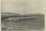
Section of the Shinarump Cliffs (middle distance), east of Pioneer Gap. Shinarump conglomerate exposed by erosion of Moenkopi formation below and the basal strata of the Chinle formation above. Upper Chinle sandstones form Vermilion Cliffs (background). |
| Photo Number |
P0013n12_052B |
| Description |
Photo shows part of the Shinarump Cliffs (middle distance), east of Pioneer Gap. Shinarump conglomerate exposed by erosion of Moenkopi formation lies below the basal strata of the Chinle formation above. Upper Chinle sandstones form Vermilion Cliffs in background. Photograph from Herbert E. Gregory Book 12: Colorado Plateau, Province, 1942-1944 |
| Creator |
Gregory, Herbert E. (Herbert Ernest), 1869-1952 |
| Date |
1944 |
| Textual Date |
1944 |
| Keywords |
Photographs; Black-and-white photographs |
| Subject |
Geology--Utah--Kane County--Photographs |
| Spatial Coverage |
Kane County (Utah) |
| Additional Information |
Photograph from Herbert E. Gregory Box 16 Folder 10. Another copy located in Herbert E. Gregory Book 12: Colorado Plateau, Province, 1942-1944 - Scrapbook identifier ark:/87278/s60904br |
| Collection Number and Name |
P0013 Herbert E. Gregory Photograph Collection |
| Collection Name |
Herbert E. Gregory |
| Rights |
 |
| Type |
Image |
| Finding Aid |
http://archiveswest.orbiscascade.org/ark:/80444/xv18865/ |
| Digitization Specifications |
Digital images produced on Epson Expression 10000 XL scanner, 24-bit color at 800 ppi and cropped using Adobe Photoshop CC 2017 (Macintosh). Archival files are uncompressed TIFF. |
| ARK |
ark:/87278/s6ps1vbv |
| Setname |
uum_map |
| ID |
1305031 |
| Reference URL |
https://collections.lib.utah.edu/ark:/87278/s6ps1vbv |