| Title |
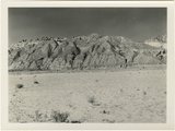
Panorama {c}. Flank of East Kaibab monocline, bordering alluvial floor of Paria Valley. Navajo sandstone (middle sky line), Upper Jurassic strata, and basal Cretaceous (left). Dips of 40 degrees decrease to 3 degrees within 1,000 feet. Kane County, UT, 1944 |
| Photo Number |
P0013n12_042_2891 |
| Description |
Photo of the flank of the East Kaibab monocline bordering alluvial floor of Paria Valley in Kane County, UT, 1944. Geology: Navajo sandstone (middle sky line), Upper Jurassic strata, and basal Cretaceous (left). Dips of 40 degrees decrease to 3 degrees within 1,000 feet. Photograph from Herbert E. Gregory Book 12: Colorado Plateau, Province, 1942-1944 |
| Creator |
Gregory, Herbert E. (Herbert Ernest), 1869-1952 |
| Date |
1944 |
| Textual Date |
1944 |
| Keywords |
Photographs; Black-and-white photographs |
| Subject |
Geology--Utah--Kane County--Photographs; Paria River Valley (Utah and Ariz.)--Photographs |
| Spatial Coverage |
Kane County (Utah); Paria River Valley (Utah and Ariz.) |
| Additional Information |
Photograph from Herbert E. Gregory Box 16 Folder 10. Another copy located in Herbert E. Gregory Book 12: Colorado Plateau, Province, 1942-1944 - Scrapbook identifier ark:/87278/s60904br |
| Collection Number and Name |
P0013 Herbert E. Gregory Photograph Collection |
| Collection Name |
Herbert E. Gregory |
| Rights |
 |
| Type |
Image |
| Finding Aid |
http://archiveswest.orbiscascade.org/ark:/80444/xv18865/ |
| Digitization Specifications |
Digital images produced on Epson Expression 10000 XL scanner, 24-bit color at 800 ppi and cropped using Adobe Photoshop CC 2017 (Macintosh). Archival files are uncompressed TIFF. |
| ARK |
ark:/87278/s6323v7r |
| Setname |
uum_map |
| ID |
1305020 |
| Reference URL |
https://collections.lib.utah.edu/ark:/87278/s6323v7r |