| OCR Text |
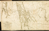
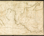
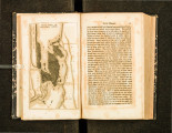
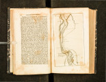
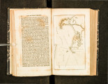
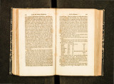
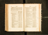
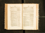
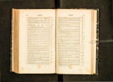
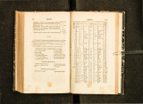
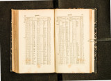
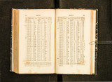
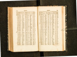
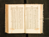
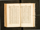
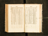
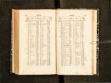
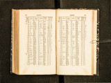
Show i·iO .liJJ pr wli...t•. gable waters of the Columbia, 398 miles; thence down the river 640 miles, to the p,,cilic occau; making a to t;.~} distance of 4 1 :1·t miles. On our return in 1806, we came fi·om T rav llcr's-tTSt crt'e k direc tly to the fall!) or the l\lissouri river, which shunens th~ dis tance about 579 mile&, <HHI is a much b ttn ro ute, reducing the distancC' from the M ississippi to the Par i fie ocean to 35 55 miles. '2 :i 7 !J miles of this distanr.c is up th MissoUI·i to the fal ls of that river; thence passing throug h the ph\ins, and across the Hocky mounta ins to the navit~ablc waters of the Kooskooskce rivt' l', a. branch of the Coh~mbia, 3·J.O miles; 200 miles of which is a goocl road, 140 m i lcg o ve r a u·cmcnclous mountain, steep and bn~kcn, (i0 rnilcs o f which is covcred scvoral fee t deep wi th ~now, on which we p assed the last of June: from the navigable piolrt or the Kooskooskcc we d<" scc ncled that l't~pi cl rivel' 7.> miles to it~ cutrancc into Le\\ i s ' ~ r iver, ancl <.!own that r iver 15-1· m iles to the Columbia, an<l thence ~· 1 J m iles to its e ntrance into the Pacific ocean. About 1130 miles of this distance is tide-water·. \V c passed several bad rapids anti na rrows, and one con sider· able fall, ~G R miles abm c the ntrancc of this river, of 37 fee t s inches.-The tot:.tl distance descend in~ the Columbian watcn 640 miles, making a total uf 3355 miles, on the mos t direct route from the Mississippi, a~ the mouth of the Missouri, t<"' the Pacific ocean. . ~ ppcncli.t'. E . T IMAT~ OF T liE \V ESTEHN L DIANS. ames of Indian n a tions ancl t hti1· p l.tccs of g cncr .tl rcsicl 'liCe. I. Sho!:. h o111 ~ e n atiou rcsid c..c.; in s pri ng· and s uu•mcr on th · west fork of 1 ,c ,~ ;~ 's river, a br-.ln t.h of the Columbia, .mel in wiute r awl fa ll on the :\i tssou- 1'1 '\ Ootlashoo t u·ihc of tht' Tu:-.hshc p ah n a tion IT side in sprin g· and sumnw r in th · Ho, ky tt\01111- taills on Cl.trkc's ri ver, and \\' inti' I' and l<tll 011 the 1\1 is<>o uri and it-; wate rs 3. Chopllllllish natio n, l'c!>idrng ()II the r OO'i lwo ~kcc river, belo w the l'u rk!l, and 0 11 Colt ·r·'.., c r eek, a nd \\ lw son u·timt• s p ass over ro the Mit-t •,oul'i 4·. Pl'ilo:.ttpo.lbh band or Clwpii!Hli~h IT"lidc 011 till 1 ooskoosk<'C, .thovc the fo rk s, and 0 11 the Slll<ll I Streams Which l'.tJJ into th a t ri VI' 1'1 Wt!:. l of l ltt' Hoc k}' Ill Oll1ll<llll s an <l C lwp u n 11 i sll r i \' n , and so metimes p.1ss ove r to the Mi-.so ttr t .(. Kimoocnim b.tml or Chopu nnish nation I'C~ i uc on Lcwts'::; 1iver, .1bove the cnt r.mcc of the K oo ~ k oo s kcc, as hi ~ h up that r i\ <.:l' as t he for k s G. Ydctpo b,wd or C h opttll lllsh I'Csl<k llll<le t• the southwc-;t lliOll lltai n ~, on a sm.lll r1ver which fal ls into Lewis's river, abovt' thl' l ' llll'<lllCe ulthc Kuuskooskcc , which tht y c.t ll \Vl'.turum 7. \ Villcwah band of Chopunnish r eside on a river of the same name, which d t ~cha rg·c <; IUH·l l into J, l'\vis's river on the sou th west ~ick , hc..:luw the forks of that nver s.Soyennom band or C hnpUtll li!->h 011 the IIOI'lh side or the rast fork or L t' \Vts's l i \ '1 r, lrot\1 i t~ junrt iUlllU the Hocky lllOil lli.!Jlt s, and o.1 L ll lt.tlt.Ar c r l'cl 9. Chopunn i ~h ur L n \ ~~·~ ri ver, be low th. ('1\ ti'UilCC or the Koos koos kcc, on cithn :-.ide of tll.tt river· to it!) junction \\ ith the C olu n d11a 10. Sokulk na ion r ~Ilk on th l: Col ll lubia, abo ve the entrance uf L (' wis's ri\ c r, as ingh up a~ the r n tt·ancc of C l ark e ' ~ ri\ c t· 11. Chimnallpu nt rc"ide on the not tin~ est ~ i de o f the Columbia, l>uth aho\'C and IH.:low the ult rann: ol Lew1s'~ riH·r, .uH.I on tlie T ~q>ln: lri , c r , w!tidtlal h; into the C olumbi.t 1,:; m ilt:s al>oyc L ewis' ::; river (iQ "'"" .. , .).J .") ,)' <" ., ,)J J3 ,") ,")' :lJ lj.() 120 ·17 J ~ 0 0 400 2000 1600 800 250 500 1..00 2300 2 tt.OO |