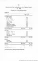
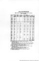
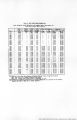
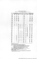
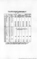
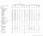
| OCR Text |
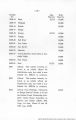
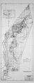
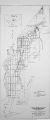
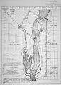
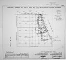
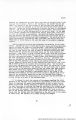
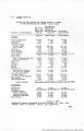
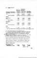
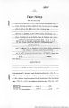
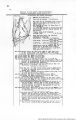
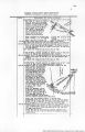
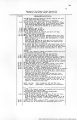
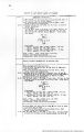
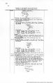
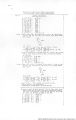
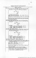
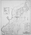
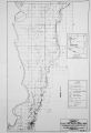
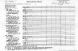
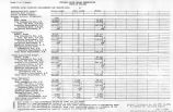
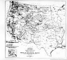
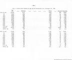
Show Boundary of Port Mohave Indian Reservation: chains Retracement for Resurvey , continued. 3.0*^8' 6"'.7.. (record courao) on random line,on part of 1st half of 6th illc of C.U.I.K. bdy. ' 2.^7 (Rocord dist.) Intersect point of original location of reestablished closing cor. of Frac .Ts. 18 and 1(: li.,K.<.<. ¦'• . ¦.-•¦< s. R. B.* M.,«.rtz. Continue line and measurement. 7.?1 (Record dist.) Intersect East Side Center Mon. of C.".T. R. Bdy..established in 1905 at restored point for Cor.No.1 of old Hay and Wood Reserv. of Camp Mojave Mil. Reserv. True course and dist. of the portion of the 1st half of the 6th mile of C.M.I.h. Bdy. bnt. the 5 mile won. m d the E.S.O. raon. are therefore, S.0oV' o"i7. ,7.31 oh*., and the closing cor. point la on true line. From ^.S.O.mon., S.l" 4' 28'HV. , (record course) on random line.on part of bth mile of C.M.I.H. Bdy. ?2.O9 (Record dist.) Diligent search in this vlcinity fails to ; reveal any trace of 5a mile mon. Set stake and continue line and measurement. 73.09 1 Fall 2j lie. W. of 6 mile mon. True course and dist, of the portion of the 6th mile of i C.U.I.R. Bdy. bet. the S.SiC. raon. and the 6 mile mon. are therefore, S.l° ?'19"W.,73.09 cha..which, to maintain original proportion bet. mon. intervals, gives ^2.87 chs.aa true length of the portion of the l8t half of 6th mile bet. the B.S.C.mon. and point for reestab-iiahnent of 5* mile mon., and 40.22 che. as the true ' of 2nd half of 6th nile of C.U.I.K. Bdy. S.l° 4' 28"W., (reoord course) on random line, on 7th and ¦ 8ith miles of C.H.I.H. Bdy. 2.12 i(Reoord <llat.) No trace of closing oOr.of secs. 3 and 10, Frac. T.l8 B..B.22 V/. ,G.* S.R. 3.4 If..Ariz. Set stake and continue line and measurement. .40.00 (Record dist.) No trace of 6? mile mon. Set stake and continue line and measurement. 80.00 l(Record diat.) No trace of 7 mile nor. Set stake and continue line and measurement. 81.82 (Record dist.) No trace of dosing cor.of secs.lO und 15,; Frac.T.l8 N..R.22 '7..G.* S.R. B.4 M.,Ari«. Set stake and continue line and measurement. 120.00 (Record dist.) No trace of 7j nile non. Set stake und continue line and measurement. 160.40 ! ?all 5 Iks. '.V. of point of original location of the 8 mile mon. ! ¦ True course und dist. of C.H.I.R, Bd;;. from 6 nile mon. to 8 mile mon. are therefore, S.i°V25"W. ,160.40 cha., whioh, to maintain original proportion bet. non. intervals, gives four intorvals of 46.10 chs. each, for .the reo8tablishment of the missing 6j, 7 and 7~ mil* mons. 1 3.1° 4'28"W.,(record course) on random line,on part of , the 1st half of Pth rniie of CM. I.P.. Bdy. 2.00 Intersect pdint of original location of dosira* cor. of a<?c 3. If t. ri iZ,' I Set stake and continue line and measurement. 37.74 |(Record di8t.) Ho trace of S3. Cor.of C.J.I.I.R. 3cy. esta1..-lished in 19^5 ut restored point for Cor.ilo.2 of old Hay and Wood Resorv. Set stake for temp. Cor.No.2 of F.H.I.R. 3i":y. Thence S.76°17' 28"W. (record course) on random line on C.'.'.i.H. Bdy. bet. the S.1. and SVI. cors. thereof, ldentitt-l v»ith part of south iire(2-3) of Bdy. of1 old hay and Wood Reaerv. 2.26 (Rocord diwt.) No trace of 83- mile mon. ! Set stake and continue line and measurement. ?3«38 i(Reoord dist.) Ho trace of closing cor.of secs.21 and 22. |
| Source |
Original book: [State of Arizona, complainant v. State of California, Palo Verde Irrigation District, Coachella Valley County Water District, Metropolitan Water District of Southern California, City of Los Angeles, California, City of San Diego, California, and County of San Diego, California, defendants, United States of America, State of Nevada, State of New Mexico, State of Utah, interveners] : |